Municipio Pucará
| Municipio Pucará | ||
|---|---|---|
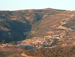
 Pucará in the evening light |
||
| Basic data
|
||
| Population (state) - population density |
2076 inhabitants (2012 census) 3 inhabitants / km² |
|
| Post Code | 07-0805 | |
| Telephone code | (+591) | |
| surface | 670 km² | |
| height | 2500 m | |
| Coordinates | 18 ° 45 ′ S , 64 ° 11 ′ W | |
|
|
||
| politics
|
||
| Department | Santa Cruz | |
| province | Vallegrande Province | |
| Central place | Pucará | |
| climate | ||
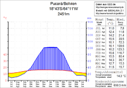
 Climate diagram Pucará |
||
The Municipio Pucará is a district in the southeastern part of the Santa Cruz Department in the South American Andean state of Bolivia .
Location in the vicinity
The municipality of Pucará is one of five municipalities (districts) in the province of Vallegrande . It is bordered by the Department of Cochabamba to the northwest , the Department of Chuquisaca to the west and south , and the Municipio Vallegrande to the north and east .
The municipality extends between about 18 ° 38 'and 18 ° 58' south latitude and 64 ° 03 'and 64 ° 19' west longitude, its expansion from west to east is up to 25 kilometers and from north to south up to 35 kilometers . The municipality borders in the west for almost its entire length on the Río Grande , in the extreme northwest on the Río Mizque .
The municipality comprises 23 municipalities ( localidades ), the central place of the municipality is the town of Pucará with 707 inhabitants ( 2012 census ) in the northern part of the district.
geography
Pucará is located in the valley of the Río Cañada in the southwestern foothills of the Cordillera Oriental . The mean annual temperature of the region is 14 ° C, the annual precipitation is 650 mm (see climate diagram Pucará), the region has a distinct daytime climate.
The monthly average temperatures vary only slightly between 11 ° C in July and 16 ° C from November to January. The region has a dry season with monthly values of less than 20 mm from May to September, the maximum precipitation values are between 100 and 125 mm in the summer months from December to February.
history
The Pucará region became known through the Argentine - Cuban revolutionary and guerrilla fighter Ernesto "Che" Guevara , who was shot in the village of La Higuera in the heart of the district on October 9, 1967 by the Bolivian army with the participation of the US secret service CIA .
Che Guevara led a small group of internationalist guerrillas who wanted to build a guerrilla army under the name ELN in Bolivia and were supported by Cuba. Before they could build a powerful group, however, they were discovered and embroiled in skirmishes with the Bolivian military, which was supported by the CIA. The troops were separated early on: Che Guevara led one group that wandered around the eastern slopes of the Andes in search of the second group and occasionally laid ambushes against the army . Contact between the two groups could not be established until the end. In the middle of 1967, the armed fighters' retreat became increasingly narrow for the Cubans. The second group was broken up on August 31, 1967; The German Tamara Bunke ("Tania la Guerillera") also died with her boss Juan Vitalio Acuña Núñez in an ambush near Vado de Puerto Mauricio .
Che Guevara's group, which at the end only consisted of 14 men, was tracked down by government troops on October 8, 1967 in the Quebrada del Churo (also: "Quebrada del Yuro" ) gorge near La Higuera . After heavy fighting, the wounded Comandante Che Guevara was arrested there and taken to the school building in La Higuera, where he was interrogated under the direction of a CIA agent. The following day, he was shot dead in the location without a trial. Che Guevara's body was supposed to be disposed of without a trace and was secretly buried in Vallegrande at the airfield.
In La Higuera, a monument in the form of a larger than life bust commemorates Che Guevara, and there is a memorial in the former schoolhouse.
population
The population of the municipality of Pucará has decreased by around twenty percent in the past two decades:
- 1992 : 2,571 inhabitants ( census )
- 2001 : 2,548 inhabitants (census)
- 2012 : 2,076 inhabitants (census)
The population density at the last census of 2012 was 3.1 inhabitants / km². The province's literacy rate is 79.6 percent, with 84.4 percent for men and 74.0 percent for women. The infant mortality rate is 6.4 percent (1992) to 5.2 percent (2001) declined.
99.6 percent of the population speak Spanish , 1.8 percent speak Quechua , and 0.1 percent speak Aymara . (2001)
99.5 percent of the population have no access to electricity , 99.2 percent live without sanitary facilities (2001) .
72.6 percent of the 594 households have a radio, 2.1 percent a television, 16.5 percent a bicycle, 1.3 percent a motorcycle, 2.0 percent a car, 0.5 percent a refrigerator, 0.2 percent a telephone. (2001)
87.6 percent of the population are Catholic , 10.9 percent are Protestant (1992) .
politics
Results of the elections for the municipal council ( concejales del municipio ) in the regional elections on April 4, 2010:
| electoral legitimate |
electoral participation |
valid votes | MAS-IPSP | VERDES | TODOS | ||
|---|---|---|---|---|---|---|---|
| 979 | 905 | 830 | 450 | 377 | 3 | ||
| 92.4% | 91.7% | 54.2% | 45.4% | 0.4% |
structure
The municipality Pucara is divided into the following two cantons ( cantones ):
- Cantón Pucará (in the northern part of the municipality) - 10 vicecantones - 12 municipalities - 1,538 inhabitants ( 2001 )
- Cantón La Higuera (in the southern part of the municipality) - 9 vicecantones - 11 municipalities - 910 inhabitants
politics
In the 2004 elections, the votes were distributed among the parties as follows:
Individual evidence
- ↑ Instituto Nacional de Estadística (INE) 1992
- ^ Instituto Nacional de Estadística (INE) 2001
- ↑ Instituto Nacional de Estadística (INE) 2012
- ↑ Acta de computo Nacional Electoral Departamentales, Municipales y Regional 2010
Web links
- Municipio Pucará - General Maps No. 70805
- Municipio Pucará - detailed map and population data (PDF 677 kB) ( Spanish )
- Department Santa Cruz - Social data of the municipalities (PDF; 4.99 MB) ( Spanish )
