Rruga shtetërore SH5
| Rruga shtetërore / Rrugë shtetërore SH5 in Albania | |||||||||||||||||||||||||||||||||||||||||||||||||

|
|||||||||||||||||||||||||||||||||||||||||||||||||
| map | |||||||||||||||||||||||||||||||||||||||||||||||||
| Basic data | |||||||||||||||||||||||||||||||||||||||||||||||||
| Operator: | Autoriteti Rrugor Shqiptar | ||||||||||||||||||||||||||||||||||||||||||||||||
| Start of the street: |
Shkodra ( 41 ° 59 ′ N , 19 ° 33 ′ E ) |
||||||||||||||||||||||||||||||||||||||||||||||||
| End of street: |
Kukës ( 42 ° 25 ′ N , 20 ° 23 ′ E ) |
||||||||||||||||||||||||||||||||||||||||||||||||
|
Qarqe : |
|||||||||||||||||||||||||||||||||||||||||||||||||
|
Course of the road
|
|||||||||||||||||||||||||||||||||||||||||||||||||
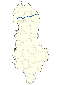
The Rruga shtetërore SH5 ( Albanian for state road SH5 ) is a national road in Albania and connects Shkodra with Kukës and the border with Kosovo .
Route
The SH 5 branches off from the SH1 south of Shkodra and leads via Vau-Deja , Puka , Fushë-Arrëz and the Qafa e Malit pass to Kukës . Shortly before, it joins the A1 motorway . The SH5 ends at the Morina / Vërmica border crossing .
The route mainly leads through mountainous, rather isolated area.
Expansion status
The road is paved throughout and at least six meters wide. It winds in many curves through numerous valleys and over many passes, which makes rapid progress impossible.
Web links
Commons : Rruga SH5 - collection of images, videos and audio files
Individual evidence
- ^ Official Directory of the Roads in Albania. (PDF) In: Ministry of Infrastructure. 2018, accessed May 13, 2020 (Albanian).

