Nature reserve Tal der Ennepe (Ennepetal)
|
Nature reserve valley of the Ennepe
|
||
|
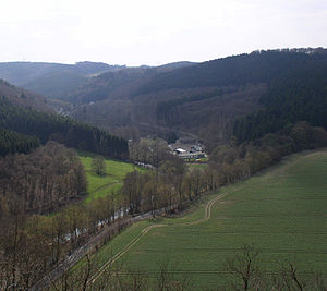
View from Hohenstein into the valley of the Ennepe with the Alhauser Hammer (center), northern part of the NSG in the valley floor |
||
| location | Ennepetal , Ennepe-Ruhr-Kreis , North Rhine-Westphalia , Germany | |
| surface | 70.53 hectares | |
| Identifier | EN-028 | |
| WDPA ID | 319192 | |
| Natura 2000 ID | (partially) DE-4710-301 (partially) | |
| Geographical location | 51 ° 17 ' N , 7 ° 24' E | |
|
|
||
| Sea level | from 195 m to 327 | |
| Setup date | 1999 | |
| Framework plan | Landscape plan 4 of the Ennepe-Ruhr district, Ennepetal / Gevelsberg / Schwelm area | |
| administration | Lower landscape authority of the Ennepe-Ruhr district , supervised by Biological Station EN | |
The nature reserve Tal der Ennepe is a 70.53 hectare nature reserve (NSG identifier EN-028) in the urban area of Ennepetal in the Ennepe-Ruhr district in North Rhine-Westphalia . The NSG was designated in 1999 and consists of seven sub-areas.
In the area, the Ennepe partially forms the border to the neighboring town of Breckerfeld . Immediately afterwards there is the NSG Tal der Ennepe of the same name (predominantly Breckerfeld) and the Ennepetaler NSG Bilstein . Large parts of the two nature reserves Tal der Ennepe have been designated as FFH area DE-4710-301 Ennepe below the dam since 2004 ; the corresponding areas are therefore part of the European Natura 2000 network of protected areas .
Area description
The NSG is the near-natural brook valley of the Ennepe with floodplain areas between the southeast border of the urban area near Bauendahl (Breckerfeld) and Gut Ahlhausen in the north. Here, the Ennepe is endowed with a high structural diversity of the course of the river and large stretches of accompanying woodland. Former hammer ponds of the iron processing industry serve as important amphibian habitats. Grassland areas with wet fallow as well as wet and poor meadows are also available in the NSG.
See also
Web links
- Nature reserve "Tal der Ennepe" in the specialist information system of the State Office for Nature, Environment and Consumer Protection in North Rhine-Westphalia


