
Hardenstein nature reserve
|
NSG Hardenstein
|
||
 The forest with the valley cut around the castle ruins Hardenstein an der Ruhr belongs to the NSG. |
||
| location | Witten , Ennepe-Ruhr-Kreis , NRW , Germany | |
| surface | 16.55 hectares | |
| Identifier | EN-005 | |
| WDPA ID | 163529 | |
| Geographical location | 51 ° 25 ′ N , 7 ° 18 ′ E | |
|
||
| Sea level | from 82 m to 143 m | |
| Setup date | November 25, 1984 | |
| Framework plan | Landscape plan Ennepe-Ruhr-Kreis, Witten-Wetter-Herdecke area (1984) | |
| administration | Lower landscape authority of the Ennepe-Ruhr district | |

The Hardenstein nature reserve is a 16.5 hectare nature reserve in the city of Witten in North Rhine-Westphalia. It is almost completely forested and is located northeast of the Herbede district near the Hardenstein castle ruins in the south of the Ruhr . Its western area is in the Ostherbede district (around 42 percent of the total area), its eastern area is in the Vormholz district (around 58 percent).
The protected area was set up with the object identifier EN-005 in the course of drawing up the landscape plan for the Ennepe-Ruhr district in 1984.
area
In terms of its natural surroundings, the Hardenstein NSG is part of the Ruhr Valley . It is only separated from the Ruhr and Herbeder Mühlengraben (cf. Stahlfabrik Friedrich Lohmann ) for a good kilometer by the route of the Ruhr Valley Railway , which runs directly along the south bank. The NSG is located on a river arch and includes large parts of the Ruhr slope , an old impact slope of the river. There is a height difference of 61 meters in the area. On the steep , wooded slopes that slope in northerly directions, there are temporary water-bearing sieves and several rocky cliffs , each of which represents valuable small biotopes.
The nature reserve is - like its surroundings - strongly shaped by the early Ruhr mining , which left numerous traces in the area, u. a. Pingen fields , tunnel mouth holes , small quarries , slope dumps and cart paths . Part of the Muttental mining hiking trail runs through the NSG and opens up most of the local mining history and listed sights. In the north-west of the nature reserve there is also the tunnel mouth of the former Flößgraben colliery , without public access and walled up .
The forest in the area is differentiated over a small area and varied according to its history of use. Some of it is old coppice forest . The most common tree species are common beech , common oak , silver birch and spruce . In some areas, sleeves are common.
The grounds of Hardenstein Castle are enclosed by the nature reserve to the west, south and east, but are not part of it. The ruin is located directly on the railway line in a small valley cut that divides the slope of the Ruhr into a western and an eastern part. In this valley an officially nameless stream flows to the Ruhr. It is locally called Deipenbecke ( nds. For "deep stream") or simply Hardensteiner Bach . The approximately two kilometer long flowing water is fed by several spring strainers that are located in the forest area south of the NSG. At the ruins of the castle, shortly before its mouth, the Deipenbecke seeps away in a mining-related "creek" (cf. St.-Johannes-Erbstollen ). In the valley floor, which was previously used as grassland , there are also some silting and already silted up small bodies of water, some of which were created as species protection measures for the midwife toads that occur in the area . The former meadow valley at the castle ruins has fallen fallow and largely overgrown with black alder .
Protection goals
Primary protection goals for the NSG are
- the preservation of a steep Ruhr slope with old beech trees, characterized by cliffs and valleys,
- the protection of small bodies of water as a habitat and a. for amphibians and
- the redevelopment of near-natural forest communities.
tourism
The forest area around Hardenstein Castle is used intensively for local recreation . Especially on summer weekends, when the “RuhrtalBahn” museum railway runs and many tourists are out and about on the Muttental mining trail and the nearby RuhrtalRadweg , there are numerous people in the area. A few hundred meters from the castle ruins, the Ruhr Valley ferry with its Hardenstein ship has been a further attraction since 2006. Pedestrians and cyclists can use it to cross over for free. It records around 200,000 passengers annually.
Problems arise from the number of visitors in two main areas. On the one hand, some day trippers bring large amounts of rubbish into the area, not only through wild barbecues on the ruins. On the other hand, many visitors to the nature reserve also move off the beaten track. As a result, some parts of the area show severe cycling and step damage and areas almost free of vegetation, which leads to increased erosion in the slope areas . In some places, especially at the historic mining sites, there is sometimes deliberate damage .

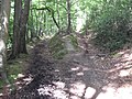
Hiking trail in the NSG

Stollenmundloch Reiger on the mining trail in the NSG
Hollow roads of the Carthäuserloch colliery in the NSG

RuhrtalBahn stop “Ruine Hardenstein”, rocky slope in the NSG


Individual evidence
- ↑ Data sheet for NSG EN-005
- ↑ a b c "Hardenstein" nature reserve (EN-005) in the specialist information system of the State Office for Nature, Environment and Consumer Protection in North Rhine-Westphalia , accessed on March 10, 2017.
- ↑ Ruhrtal ferry: ship christening on the Ruhr. ( Memento of the original from November 26, 2013 in the Internet Archive ) Info: The archive link was automatically inserted and not yet checked. Please check the original and archive link according to the instructions and then remove this notice. 2010
Web links

Old Ruhr-Katzenstein | At the Nockenberg | Bilstein (Ennepetal) | Deilbachtal | Elbschebach Witten Bommerholz | Felderbachtal | Freebach | Gevelsberg City Forest | Hardenstein | Hasper Bachtal | Heilenbeck Valley | Kermelbach | Klutert cave and Bismarck cave | Krabbenheider Bach in Gevelsberg | Maasbecke | Upper Felderbachtal | Upper Sprockhöveler Bachtal | Ruhraue Hattingen Winz | Ruhraue Witten-Gedern | Acid Epscheid | Southern Sprockhöveler Bachtal | Südholz | Brambecke Valley | Valley of the Ennepe | Valley of the Ennepe (Ennepetal) | Fastenbecke Valley | Lower Sprockhöveler Bachtal | Forest at the upper Paasbach | Valley of the Wolfsbecke | Wupperschleife Bilstein-Daipenbecke