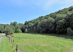
At the Nockenberg
|
Am Nockenberg nature reserve
|
||
|
Am Nockenberg nature reserve |
||
| location | Sprockhövel , Ennepe-Ruhr-Kreis , North Rhine-Westphalia , Germany | |
| surface | 15.21 ha | |
| Identifier | EN-016 | |
| WDPA ID | 318107 | |
| Geographical location | 51 ° 20 ' N , 7 ° 13' E | |
|
|
||
| Sea level | from 210 m to 271 | |
| Setup date | 1995 | |
| Framework plan | Landscape plan Ennepe-Ruhr-Kreis, Hattingen / Sprockhövel area (1998) | |
| administration | Lower landscape authority of the Ennepe-Ruhr district , supervised by Biological Station EN | |
The Am Nockenberg nature reserve (NSG identification EN-016) lies entirely in the Obersprockhövel district of the North Rhine-Westphalian town of Sprockhövel in the Ennepe-Ruhr district . It is around 15 hectares and includes a stream valley with forest and grassland areas . It is named after the Nockenberg farmyard located in the north of the area (formerly also Nackenberge ).
area
In terms of natural space , the area belongs to the Märkisches Layerrippenland , a hilly landscape south of the Ruhr in the Rhenish Slate Mountains . The nature reserve extends for around 900 meters along an unnamed stream that flows into the Felderbach in the south of the area . There is a height difference of 61 m within the area.
A little more than half of the area is taken up by beech forest rich in old wood or oak-beech mixed forest; holly is common in parts of the old beech tree population . The grassland areas in the area mainly serve as pastures for cattle ; smaller subregions as wet meadows and wet wastelands with Hochstaudenfluren trained. In the case of flowing waters, in addition to the stream with its floodplain, several source inflows are particularly important, which are characterized by a high structural diversity. Wooded fringes have largely developed along the waters, in which black alder and ash trees dominate. In the southern NSG section Am Bischof there is a no longer used fish pond .
Löhener Straße divides the nature reserve into two parts. The areas surrounding the NSG are located in two landscape protection areas (LSG Stüter / Sprockhövel / Hiddinghausen in the east and LSG Niederbredenscheid / Elfringhausen in the west).
Protection goals
The protection of the area serves the preservation of communities and habitats of wild, partly endangered plant and animal species. The primary protection goals are the preservation and restoration of a near-natural stream valley with extensive forms of use and the preservation of structurally rich forests with a high proportion of old wood.
tourism
The area is not developed for tourism. However, there are good views of the Bachtal from Löhener Straße. The pastures in the area are fenced. In the forest to the east of the brook, the mandatory roads always apply ; this area is accessible via a detour from the Herzkämper-Mulde-Weg (the hiking trail itself runs in the south outside the NSG).
See also
Individual evidence
- ↑ a b c Topographical Information Management, Cologne District Government, Department GEObasis NRW ( information )
- ↑ a b c d nature reserve "EN-016 Am Nockenberg" in the specialist information system of the State Office for Nature, Environment and Consumer Protection in North Rhine-Westphalia
- ↑ a b c d e The district administrator of the Ennepe-Ruhr district (ed.): Ennepe-Ruhr district - landscape plan area Hattingen / Sprockhövel . Schwelm 1998, Section 3.1.8, p. 52-53 .


