
Ruhraue Hattingen Winz nature reserve
|
NSG Ruhraue Hattingen-Winz
|
||
_02_ies.jpg) View from Isenberg into the NSG |
||
| location | Hattingen , Ennepe-Ruhr-Kreis , NRW , Germany | |
| surface | 119.37 ha | |
| Identifier | EN-010 | |
| WDPA ID | 319020 | |
| Geographical location | 51 ° 24 ' N , 7 ° 9' E | |
|
||
| Sea level | from 60 m to 94 m | |
| Setup date | August 15, 1998 | |
| Framework plan | Landscape plan Ennepe-Ruhr-Kreis, Hattingen-Sprockhövel area (1998) | |
| administration | Lower landscape authority of the Ennepe-Ruhr district , supervised by Biological Station EN | |

The nature reserve Ruhr lowlands Hattingen Winz is a turn 119 hectares , ie almost 1.2 km² nature reserve on the Ruhr in North Rhine-Westphalia, Germany. It is located entirely in the Winz district in the southwest of the Winz-Baak district of Hattingen . The NSG lies in a loop of the river and includes a meadow area characterized by grassland , which extends for around five kilometers along the bank on the right or north side of the Ruhr.
The protected area was established as part of the Ennepe-Ruhr district's landscape plan preparation in 1998. It bears the object identifier EN-010 and its CDDA code is 324013.
area
The NSG Ruhraue Hattingen-Winz is part of the natural spatial unit of the Ruhr Valley . There is a difference in altitude of 34 meters in the area. The highest point of the terrain is in the east within a 4 hectare mixed deciduous forest area at Knäppchen . The lowest point is the water level of the Ruhr; in the event of flooding , some parts of the area are flooded. Since the Ruhr was made navigable in the 18th century, the river bank in the NSG has been provided with rocky groynes - with the exception of a small section in the northwest . These protrude up to 50 meters into the river and are mostly covered with perennials, e.g. Partly overgrown with trees. The groynes, as well as the calmed water zones that silt up in some places, are part of the nature reserve.
Large parts of the protected area were used for drinking water in the 20th century . After this use was abandoned, partly illegal recreational uses became established in the floodplain area . In addition to wild camping and barbecuing, the high number of free-roaming dogs , which scared off breeding birds and drove them away, was problematic for several years .
In 1995 the area in the Ruhrschleife passed from Gelsenwasser AG to the ownership of the state of North Rhine-Westphalia . Major renaturation measures had been implemented by 1999 . Among other things, sheet pile walls from the old filter basins were removed, new shallow flood troughs were created in the area and some groups of trees were planted. In 1998 the area was placed under nature protection by the Ennepe-Ruhr district .
To this day, an approximately 1.8 km long flood channel with accompanying woodland runs through the south and south-west of the area. The former filter basins in the northwest are now renatured still waters that are also used by amphibians for spawning .
Several high-voltage - power lines across the area; some masts are within the protected area.
Protection goals
This area is a large, only extensively used section of the Ruhr meadows in which over 120 species of birds rest and / or breed. The proportion of endangered species is high.
Because of its rarity and special character, the primary protection goals for the NSG are:
- the preservation of communities and habitats of wild life, e.g. T. endangered plant and animal species,
- the restoration and development of a typical meadow landscape with the creation of an alluvial forest .
tourism
A large part of the area has been grazed by a herd of semi-wild Heck cattle since the end of the 20th / beginning of the 21st century and is not accessible to visitors. Some of the fenced-in areas can be entered on guided tours. However, these only take place outside of the breeding season and irregularly.
The Isenberg, on which the Isenburg is located, offers a good view of the Ruhrbogen winegrowers and the nature reserve on the opposite southern bank of the Ruhr . On the south bank there is also a well-developed and intensively used touristic footpath and cycle path ( RuhrtalRadweg ), from which the historic towpath branches off in one section below the Isenberg . The old towpath is open to pedestrians.
Water hikers are allowed to drive on the Ruhr, but must keep away from the right bank area with the groynes (including the water zones between the groynes) belonging to the nature reserve.

Heck cattle in the NSG, old groynes on the banks of the Ruhr
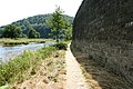
Historical towpath , NSG on the opposite bank

Bathers in the Ruhr, NSG in the background

Raft trip on the Ruhr, NSG in the background
_01_ies_(cropped).jpg)


Individual evidence
- ↑ a b data sheet for NSG EN-010.
- ↑ cf. RA / WAZ : Despite the ban: thousands of people in the floodplain. November 11, 2002 (PDF; 494 kB)
- ↑ a b c Biological station Ennepe-Ruhr-Kreis: NSG "Ruhraue bei Hattingen Winz".
- ↑ a b c d Biological Station Ennepe-Ruhr-Kreis: Ornithological mapping 2001 in the NSG "Ruhraue bei Hattingen-Winz". Short report (PDF; 289 kB)
- ↑ a b Nature reserve "Ruhraue Hattingen Winz" (EN-010) in the specialist information system of the State Office for Nature, Environment and Consumer Protection in North Rhine-Westphalia , accessed on March 9, 2017.
Web links

Old Ruhr-Katzenstein | At the Nockenberg | Bilstein (Ennepetal) | Deilbachtal | Elbschebach Witten Bommerholz | Felderbachtal | Freebach | Gevelsberg City Forest | Hardenstein | Hasper Bachtal | Heilenbeck Valley | Kermelbach | Klutert cave and Bismarck cave | Krabbenheider Bach in Gevelsberg | Maasbecke | Upper Felderbachtal | Upper Sprockhöveler Bachtal | Ruhraue Hattingen Winz | Ruhraue Witten-Gedern | Acid Epscheid | Southern Sprockhöveler Bachtal | Südholz | Brambecke Valley | Valley of the Ennepe | Valley of the Ennepe (Ennepetal) | Fastenbecke Valley | Lower Sprockhöveler Bachtal | Forest at the upper Paasbach | Valley of the Wolfsbecke | Wupperschleife Bilstein-Daipenbecke