
Neubrügg
Coordinates: 46 ° 58 ′ 26 " N , 7 ° 25 ′ 41" E ; CH1903: 599204 / 202520
| Neubrügg | ||
|---|---|---|
 |
||
| use | Private transport | |
| Convicted | Aare | |
| place | Kirchlindach on the municipality border with Bremgarten | |
| Entertained by | Civil engineering office of the canton of Bern | |
| construction | Brick covered wooden bridge on stone pillars | |
| overall length | 92.2 m | |
| width | 5.8 m - shoulder 1.1 m + roadway 4.6 m + shoulder 1.1 m | |
| Number of openings | 5 | |
| height | 6 m | |
| Load capacity | 3.5 t / m 2 | |
| Headroom | 2.3 m - portal 3.5 m wide, single-lane drivable | |
| building-costs | 6300 pounds | |
| completion | 1534/1535 | |
| location | ||
|
||
| Above sea level | 486 m | |

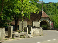
The Neubrügg , also called Neubrück or Neubrücke , is the oldest surviving wooden bridge in the canton of Bern in Switzerland and leads across the Aare near Bremgarten , where it connects the municipality of Kirchlindach with the Bern Neufeld district.
In 1534/35, the Neubrügg replaced a bridge built in 1466 as a replacement ferry at the same location, which connected Kirchlindach with Bern as early as 1467. It is a covered wooden bridge on four stone pillars made of tuff , nagelfluh and sandstone . The wooden construction consists mainly of fir wood , oak wood was also used for important load-bearing elements . The road bridge was an important customs office until 1838.
In terms of traffic, the Neubrügg was replaced in 1913 by the newly built Halen Bridge , 800 m downstream . This brought a significant improvement in the traffic connection between the northern agglomeration and the city of Bern.
The Neubrügg is listed in the inventory of historical traffic routes in Switzerland as an object of national importance and is a cultural asset of national importance .

Neubrügg - east side

Neubrügg - interior view, wooden structure and asphalt roadway

Neubrügg - west side
Neubrügg - south portal


swell
- Staff, Guy Schneider ( photos 2001): BE 29.4.1 Stuckishaus / Neubrück. (PDF; 321 KB) IVS Documentation Canton Bern. In: Inventory of historical traffic routes in Switzerland IVS . Federal Roads Office FEDRO , November 21, 2006, p. 3 , accessed on August 10, 2017 : "Importance national"
- Guy Schneider: Historic traffic routes in the canton of Bern BE. (PDF; 4.3 MB) Bernese bridges: diversity of materials and shapes. In: Inventory of historical traffic routes in Switzerland IVS , canton booklets. Federal Roads Office FEDRO , 2003, p. 64, page 49 , accessed on 10 August 2017 .
See also
- List of cultural assets in Bern in District II, Länggasse-Felsenau
- List of cultural assets in Kirchlindach
Web links
- Neubrügg. In: Structurae
- Information about the Neubrücke on g26.ch ( Memento from January 8, 2011 in the Internet Archive )
- Neubrügg in the interactive IVS - GIS of the federal government
- Official website of the Civil Engineering Office of the Canton of Bern
- Official website of the Federal ITS department - on the website of the Federal Roads Office FEDRO
- The inventory of the historical traffic routes in Switzerland IVS - on the website of the Federal Roads Office FEDRO
Individual evidence
- ^ Anne-Marie Dubler : Neubrügg (Bremgarten near Bern) built in 1466. In: Historical Lexicon of Switzerland .
- ^ Anne-Marie Dubler: Kirchlindach connected to Bern from 1467 via the Neubrücke (Kirchlindach). In: Historical Lexicon of Switzerland .
- ^ Staff, Guy Schneider ( photos 2001): BE 29.4.1 Stuckishaus / Neubrück. (PDF; 321 KB) IVS Documentation Canton Bern. In: Inventory of historical traffic routes in Switzerland IVS . Federal Roads Office FEDRO , November 21, 2006, p. 3 , accessed on August 10, 2017 : "Importance national"