
New pond (Solling)
| New pond | ||
|---|---|---|

|
||
| The new pond with a view of the north bank | ||
| Geographical location | 7 km north of Uslar , Solling , Lower Saxony | |
| Drain | Ilme | |
| Location close to the shore | Dassel , Uslar , Holzminden | |
| Data | ||
| Coordinates | 51 ° 43 ′ 16 ″ N , 9 ° 37 ′ 0 ″ E | |
|
||
| Altitude above sea level | 340 m above sea level NN | |
| volume | 3790424 feet 3 94468 m 3 |
|
|
particularities |
Former raft pond created in 1737 |
|


The New Pond is a former raft pond in the middle of Solling about 10 km southwest of Dassel ( Northeim district , Lower Saxony ) .


geography
The pond is on the L 548 between Dassel and Uslar and belongs to the community-free area of this low mountain range , in the Northeim district . It lies in a depression between the wooded elevations of Hahnenbreite (452 m) and Großer Mittelberg (383 m).
The still water is fed from an unnamed stream. Its water comes from the water catchment area to the west, which partly consists of hillside spring moor and is also the source area of the flowing stream, the Ilme .
history
The New Pond was recreated in 1737 as the second of two neighboring raft ponds after the Lakenteich and was therefore named that way. The purpose was to facilitate the transport of beech and oak wood through the Ilme to places on a leash . Since this use, like the Lakenteich, has been discontinued, the New Pond has been one of the local recreation areas of the surrounding cities. Hikers use the new pond as a starting point for forest hikes.
The fen in the source area, which contributes to the water supply into the pond, is in a renaturation phase of several years. For this purpose, numerous trees were removed from it, so that only their stumps remain. The state of waterlogging was also improved by closing drainage ditches.
Flora and fauna
Spruce, birch and some bushes line the new pond. On the western bank area, the iris blooms conspicuously in summer .
In addition, the New Pond, like the Lakenteich, offers amphibians and dragonflies . As part of a herd test following dragonfly species were detected: Common Emerald Damselfly , Lestes Dryas , damselfly , Common Blue Damselfly , Azure Damselfly , common hawker , hawker , Great Emperor Dragonfly , brilliant emerald , Vierfleck , Plattbauch , yellow-winged darter , common darter , Eastern leuccorhinia and Little Moss Maiden . There are hardly any dragonflies in the surrounding forest, even in the Friedrichshauser Bruch not far to the north, only one species, the great darter, could be detected, so that the Solling ponds have the character of an island. In order to improve the connecting function that the Ilme, which flows out of the New Pond, has for numerous species, the spruce trees in the river section near the pond were felled around 2010 and some chestnuts were planted instead.
Picture gallery

Footbridge for water level monitoring in the hillside spring moor to the west
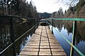
Footbridge to the overflow structure
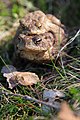
A pair of amphibians on the spawning migration at Neuer Teich

Driving common toad in the new pond


See also
Web links
Individual evidence
- ^ Karl Friedrich Baur: Forest Statistics of the German Federal States - A Result of Forest Travel, First Part, 1842, p. 266
- ↑ Round trip to the Lakenteich and New Teich in Solling ( Memento of the original from October 11, 2015 in the Internet Archive ) Info: The archive link was automatically inserted and not yet checked. Please check the original and archive link according to the instructions and then remove this notice.
- ↑ Werner Schmidt: Odonaten-Funde in the area of Einbeck, in: Nachrichtenblatt der Bayerischen Entomologen, Volumes 13-18, 1964, P. 91ff