
Neusser Strasse (Cologne)
The Neuss road is 5.3 km long arterial road in Cologne that the Ebertplatz north through the neighborhoods Neustadt-Nord , Nippes and Weidenpesch until after Longerich leads. From there it continues further north as Neusser Landstrasse and finally ends in Neuss .


History of origin
Neusser Straße already existed during Roman times .
Roman and Middle Ages
For the Romans, Neusser Strasse was not the northern continuation of the inner-city Cardo maximus , but mainly Niehler Strasse, which ran parallel to the east; Neusser Strasse was only used as a transport route when the Rhine flooded. The old Römerstraße ran from the Eigelstein over the Neusser Straße, Agneskirche / Neusser Platz, Niehler Straße, Sebastianstraße, Rheinufer Merkenicher Hauptstraße, Alte Römerstraße, Alte Neusser Landstraße and then on towards Neuss.
The expansion of the Roman Rhine Valley Road took place in AD 44, which enabled the relocation of troops to take place more smoothly. The construction of the legionary camp (Koenen camp at the mouth of the Erft in Neuss) began in AD 44. The Romans called today's city Neuss Novaesium , which was connected to Cologne by the Roman Rhine Valley Road.
Between May and July 1236, the geography- savvy Benedictine Abbot Albert von Stade traveled on horseback on 72–111 day stages from Stade to Rome ( Via Romea ), using the section from Cologne to Neuss ("Nuße") on the former Roman Rhine Valley Road on his way back, the length of which he put between the two places at 5 miles. For his way there via France he needed 111 stages, the way back was in 72 stages over the Brenner. In his Latin travel record "Das Stader Itinerar" (written as a fictional dialogue; published in 1240) he left a detailed description of the path and the rest routes for the following generations.

Neusser Straße 182 - Dampfmühlenwerke Heinrich Auer GmbH (around 1860)

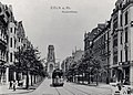
Neusser Straße - towards the cathedral (approx. 1900)

Eigelstein - View from the Eigelsteintorburg onto Neusser Straße towards Agneskirche (around 1901)
Neusser Strasse towards St. Agnes (1907)

Neusser Straße 242–246, Bluhm Brothers department store (around 1910)


The first settlement at the height of today's Mauenheimer Strasse and Florastrasse has been documented since 1549 as "am Nippes". Either the place name is derived from “Niep” for a damp depression and reminds us that an arm of the Rhine once ran in this area and the subsoil was accordingly swampy, or “Nepp” indicates a hill or a small hill. Today's Neusser Strasse is named after the city of Neuss and was first mentioned in the Middle Ages in the village of Merheim in a document from 1382 as "via Nussiensis" or "strata Nussiensis", and in 1487 in Cologne-Feldkassel as "Nuysser straisse". In the first Cologne cityscape from 1570 , drawn by Arnold Mercator , it bears the name “Straiß off Nuyß”. The Schweidkarte "Description and abrises of the Collnisch Schweidts, with its remarks, paths, divorces, in and surrounding villages, heuseren, lands" by Abraham Hogenberg (after 1609) called them "Neysser Stras". It is entered in the Cologne city map from 1752 as the “route to Nuys”. In 1807 the cartographer Jean Joseph Tranchot called it "Grande Route de Neuss à Cologne" (Great Road from Neuss to Cologne) during the French era .
Founding period
Since the outer city wall in this area was completed in September 1825, Neusser Strasse developed into Torstrasse, because it led to the “Neusser Tor” ( Fort X of the Cologne fortress ring ). On December 4, 1850, the Auer mill operated by Heinrich Auer was put into operation at today's Neusser Strasse 182 / corner of Auerstrasse, which was abandoned in 1905 and demolished in 1909. Auerstrasse was named in 1911 after the flour mill entrepreneur Heinrich Auer. In November 1869, the pharmacist Ignatz Trapp received approval to build the Flora pharmacy at no. 192. In 1875, the manufacturer Wilhelm Friedrich Kretzer (born November 14, 1850 in Cologne, † April 15, 1903) founded together with Julius Wirtgen (* July 20, 1843 in Koblenz, January 10, 1928 in Cologne) at today's Nordstrasse 15 the company "Kretzer & Wirtgen GmbH", which produced technical lubricants such as resin products and was liquidated after 1934.
At the beginning of 1876, the municipal council of the - still independent - Nippes authorized its mayor to approve the establishment of a horse-drawn tram line in Cologne-Nippes. The introduction of these lines to Cologne was approved by the Cologne city council through a concession from October 19, 1876. A contract dated July 19, 1882 between the city of Cologne and the operator Ernst Hardt & Co. provided for, among other things, a horse-drawn tram line from the city limits via Neusser Strasse and Eigelstein to Allerheiligenstrasse. The last horse-drawn tram ran from Nippes to Flora on May 22, 1907, when the railway had already been largely electrified. The electric “Querbahn” has been running since December 31, 1902, from Eifelplatz via the Cologne rings and Neusser Strasse to Nippes to the Mauenheimer Strasse junction (line 10).
The building plans of the Cologne city architect Josef Stübben provided for additional living space from 1880 onwards as part of the city expansion through the rounding off of the Neustadt Nord . Since then, residential quarters for workers have emerged between Neusser Strasse and the freight yard. It was given its current name during the ongoing construction work in the city council on May 10, 1883.
Modern times
On December 31, 1902, the "Querbahn" opened as a horse-drawn tram ("Pädsbahn") from the Mauenheimer Strasse junction via Neusser Strasse / Eigelsteintor / Eigelstein to Allerheiligenstrasse. An experimental bus operation began on May 22, 1907. During the Nazi era , Neusser Strasse was allowed to keep its name, because it met the requirements of a circular issued by the Reich Government in July 1939, which concerned street names: "For streets that lead to neighboring communities, the name of the neighboring community is usually to be chosen". During the Second World War, high-speed bombers of the Royal Air Force also bombed the Neusser Strasse area (Riehl, Weidenpesch and Nippes), several times on July 8, 1944 and again on August 6, 7, 8, 9 and 28, 1944 Further air raids, which again included Neusser Straße, followed on October 14th and 18th and November 27th, 1944. The devastating effect can be measured by the fact that only one mine falling on Neusser Straße No. 225 also includes the neighboring houses No. 219, 221 and 223 destroyed. The degree of destruction in the north of Cologne was particularly high. The peculiarity arose that on the east side of Neusser Strasse many buildings from the Wilhelminian era were preserved, while entire streets had to be rebuilt on the west side. The quarter around Neusser Platz is best preserved. On the east side of Neusser Strasse, four to five-story buildings from the Wilhelminian era continue to dominate, as this part of the commercial street was only destroyed to a below average extent.
There were many cinemas on Neusser Straße that no longer exist today. The Tivoli (no.216) was the largest with 700 seats and opened in 1922, followed by Filmburg Nippes ( no.264 ) 536 seats (1928), Viktoria ( no.338 ) 499 seats (1946) Park-Theater (No. 592) 401 seats (1951) or the Biophon (No. 265) with 195 seats (before 1919).
Buildings


As there were only a few farmsteads along Neusser Straße up to the middle of the 19th century, apart from the village of Merheim (today's Weidenpesch), historical buildings are relatively rare. The development of the Agnesviertel and the adjoining Nippes district did not begin for the most part until the Wilhelminian era, while the Weidenpesch district to the north was mainly developed in the 20th century.
The only church located directly on Neusser Strasse is St. Agnes , which gave the surrounding district its name. It was completed in October 1903. The “Alhambra” forms the core of a strictly symmetrical cave garden designed after 1903 with a fountain by Karl Foerster in the middle of the green area of the inner green belt (“Nippeser Schweiz”) that borders Neusser Strasse. The brewery Stüsser (No. 47) has existed since 1920 in a house from the Wilhelminian era from 1889, its founder Peter Stüsser invented the recipe for a herbal liqueur ("Stüssers Herb Bitter") in 1904. The youth traffic school in Cologne at No. 164 opened in June 1957 with an area of 6000 m² and trains a maximum of 20,000 children a year. The restaurant "Zum Kornbrenner" (No. 171) has been occupied since 1874 (then Neusser Straße No. 1) and has been at its present address since 1892. Galeria Kaufhof (No. 242–244) has the largest retail space with 5,500 m² , followed by the Rewe Group with 800 m² (No. 206). Since 1904 the Jewish brothers Julius and Eduard Bluhm owned the department store "Gebrüder Bluhm" with a prominent globe on the roof, which was taken over by Leonhard Tietz AG on October 10, 1927 at the place of today's Kaufhof . Bombs destroyed the 3rd and 4th floors in 1941, and the provisional resale began in autumn 1945 under the name Kaufhof AG . The new building of a two-storey house opened on September 23, 1954. After seven months of renovation and one storey more, the reopening took place on October 30, 1962, guest Willy Millowitsch presented the symbolic key. With a sales area of just 5,500 m², this branch is one of the 10 smallest Kaufhof branches in Germany.
The "Nippes Tower" (No. 284–286; from 1970 has been called this since it was marketed in 2003 as a condominium complex) is a 13-story building that clearly towers over the neighboring buildings. The grin heads at No. 293 are well-preserved elements of the building jewelry from the early days. The Kölsch pub Em Golde Kappes (No. 295) is known nationwide and was opened on August 30, 1913 by the Nippes landlord Matthias Becker. In an advertisement he asked for “kind approval” at the opening of the “top-fermented beer house”. Strictly speaking, the Nippes district town hall (No. 450), which opened in December 1999, is already in the Weidenpesch district. In 1698, the still preserved inn "Zur alten Customs Border" (No. 549) opened and is one of the oldest inns in the city. It is located on the former city limits of the city of Cologne. Numerous residential and commercial buildings are listed (see list of architectural monuments in Cologne's Nippes district ).
In 1987 the street was still one of the largest sub-centers in Cologne with around 180 shops and service facilities . However, the closure of many specialist shops could not be avoided in the period that followed . As part of the Smart City urban development project , a section of Neusser Strasse was named the city's first “Klimastrasse” in January 2013 and energy-saving projects were initiated.
meaning
Along with Aachener, Luxemburger and Bonner Strasse, Neusser Strasse is one of the four major arterial roads on which the city's necropolis used to be . As an arterial road, it serves the commuter traffic between the city center and the northern and northwestern Cologne districts. It is one of the three arterial roads in Cologne that start from the still existing archways. Despite its considerable length of 5.3 km, it is not the longest street in the city. The longest street in Cologne is the military ring street with 21 km, the Aachener street measures 8.7 km from the Hohenzollernring to the city limits in Cologne-Weiden, the crossing inner canal street is 4.7 km shorter.
In the Cologne-Nippes district, Neusser Strasse is a narrow main traffic and shopping street; At that time, the route to the north of Cologne on the left bank of the Rhine was the busiest section of the entire network outside the city center. Important streets that merge or cross into Neusser Straße are Innere Kanalstraße, Kempener Straße, Florastraße, Niehler Kirchweg, the Cologne Belt , which is not yet completed in the Neusser Straße area, with the overpass of the elevated railway, Friedrich-Karl-Straße, Scheibenstraße / Kapuzinerstraße and Wilhelm-Sollmann-Strasse. As the central axis in Neustadt-Nord , it is the most important arterial road and the shopping center in the region. Neusser Straße forms the center of the Agnesviertel as well as the districts of Nippes and Weidenpesch.
location
Neusser Strasse begins at Ebertplatz and leads through the Agnesviertel , Cologne-Nippes , Cologne-Weidenpesch and on the edge of Cologne-Longerich to Militärringstrasse. From there it runs as Neusser Landstrasse to the city limits in Cologne-Worringen . Via Dormagen , where it is initially called Kölner Straße, later Krefelder Straße, it finally reaches Neuss. Neusser Straße divides the districts of Nippes and Weidenpesch into two equally large areas.
Since August 25, 1974, the tram has been running as a subway to Mollwitzstraße via the stops U-Bahnhof Ebertplatz , U-Bahnhof Lohsestraße , U-Bahnhof Florastraße and U-Bahnhof Neusser Straße / Gürtel . This traffic-independent routing has, on the one hand, led to a reduction in travel times for public transport users and, on the other hand, has straightened out above-ground vehicle traffic on Neusser Straße. The subway below Neusser Straße was started as one of the first Cologne subway lines to relieve the heavily used Neusser Straße. In order to shorten travel times from the north of Cologne as much as possible, greater distances between stops were chosen under Neusser Straße - but at the price of a poorer accessibility. For cost reasons, the tunnel could only be led to the Mollwitzstrasse stop. Originally, an underground tour was planned as far as Wilhelm-Sollmann-Straße, where the railway line splits into two branches. Therefore, the current tunnel ramp is designed as a provisional ramp, which will facilitate future construction. The four-track train station on Ebertplatz distributes the different directions to the Kölnerringen and the Dom / Hauptbahnhof underground station .
The Bundesstraße 9 is led from the south via the Kölnerringen via the Neusser Straße and its northern extension (Neusser Landstraße) out of the city.
Individual evidence
- ↑ At that time the Rhine flowed further east, hence the change of direction to Merkenich.
- ^ Gebrüder Mann-Verlag, Cologne Yearbook for Pre- and Early History , Volumes 5/5, 1961, p. 31
- ^ Jürgen Huck, Neuss: Der Fernhandel und die Hanse , Stadtarchiv Neuss, 1984, p. 54
- ↑ Thomas Szabó, The World of European Roads: From Antiquity to Early Modern Times , 2009, p. 90 f.
- ^ Rolf Watzka, Cologne Nippes district , 2013, p. 38
- ↑ Kölner Stadtanzeiger from June 2, 2015, Joachim Frank: Köln Nippes - the Veedel with the most charming name
- ^ For trinkets, Flora-Apotheke: Competent advice in the service of health , Issue 2 / June, 2015, p. 31
- ↑ Thomas Deres, Der Kölner Rat: Biographisches Lexikon , Volume 1, 2001, p. 126
- ↑ Thomas Deres, Der Kölner Rat: Biographisches Lexikon , Volume 1, 2001, p. 163
- ↑ Pit Hoff / Harald Niemann, Deutsche Kolonialgeschichte im Afrikaviertel , in: Nippes-Magazin, Issue 1, March 2017, p. 24
- ↑ Gabi Steinebach, The image of the city in the work of Jakob and Wilhelm Scheiner , 1992, p. 107
- ↑ Fred Kaufmann / Dagmar Lutz / Gudrun Schmidt-Esters, Cologne street names: Neustadt and Deutz , 1996, p. 103
- ↑ Designation principles of July 15, 1939, § 3, f) (3)
- ↑ Nippes-Magazin, 60 Years of Youth Traffic Exercise Area in the Green Belt , Issue 2 / June, 2017, p. 8
- ↑ Kölner Stadtanzeiger of July 18, 2008, insolvency for Golde Kappes registered
- ↑ Klaus Zehner, City Districts and Centers in Cologne: A Socio-Geographical Study of Spatial Structure and Spatial Behavior in the Big City , Volumes 46–47, 1987, p. 48
Web links
Coordinates: 50 ° 57 ′ 54 " N , 6 ° 57 ′ 13.3" E