Nonnenwald (Penzberg)
|
Nun forest
City of Penzberg
Coordinates: 47 ° 46 ′ 19 ″ N , 11 ° 22 ′ 43 ″ E
|
||
|---|---|---|
| Height : | approx. 615 m above sea level NHN | |
| Residents : | 12 (1987) | |
| Postal code : | 82377 | |
| Area code : | 08856 | |
|
Location of Nonnenwald in Bavaria |
||
|
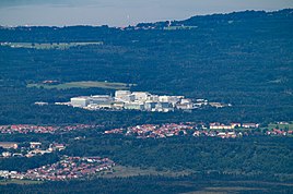
Nonnenwald (center) from the Benediktenwand
|
||
Nonnenwald is a district of the small Upper Bavarian town of Penzberg in the Weilheim-Schongau district . The industrial town is located about two kilometers north of the Penzberg town center in the forest of the same name.
history
The area of the Nonnenwald belonged to Albert Freiherr von Pruckberg until 1291, who then sold it to the Angerkloster in Munich . This put on some fish ponds in and around the area , of which only the Stocksee exists today . The place name is probably derived from the nuns of the Angerkloster as owners of the forest. Vordermeir , Fischhaber, Steigenberg, Kirnberg , Wölfl , Reindl , Heinz and Daser were referred to as farms in the Nonnenwald (“in the forest”) . There was no "Nonnenwald-Hof".
From 1913, the sinking of a shaft for the extraction of pitch coal as part of the Penzberg mine began on the site of today's Nonnenwald district . Production began in 1919, and from 1933 the Nonnenwaldschacht was the last to be operated by the Penzberg mine. Due to a lack of profitability, the mine was closed on September 30, 1966 and the shaft was filled soon afterwards.
Today the industrial town of Nonnenwald is about half a square kilometer. Roche Diagnostics set up a biotechnology center in almost the entire area , which today is the largest in Europe with around 6,000 employees.
In the local registers of 1950 and 1973, the place was classified as a "settlement", and in 1987 as an "industrial site".
| year | Residents | Residential buildings |
|---|---|---|
| 1950 | 210 | 10 |
| 1966 | 154 | |
| 1970 | 137 | |
| 1987 | 12 | 2 |
Attractions
- Mining monument: model of the former Nonnenwald winding tower, erected in 2018
Web links
- Nonnenwald in the location database of the Bavarian State Library Online . Bavarian State Library
Individual evidence
- ↑ a b Bavarian State Office for Statistics and Data Processing (Ed.): Official local directory for Bavaria, territorial status: May 25, 1987 . Issue 450 of the articles on Bavaria's statistics. Munich November 1991, DNB 94240937X , p. 159 ( digitized version ).
- ↑ Karl Luberger: history of the city Penzberg . Ed .: City of Penzberg. 1st edition. 1969, p. 11 .
- ↑ Karl Luberger: history of the city Penzberg . Ed .: City of Penzberg. 1st edition. 1969, p. 22 .
- ↑ Karl Luberger: history of the city Penzberg . Ed .: City of Penzberg. 1st edition. 1969, p. 43 ff .
- ↑ Karl Luberger: history of the city Penzberg . Ed .: City of Penzberg. 1st edition. 1969, p. 76 .
- ↑ Karl Luberger: history of the city Penzberg . Ed .: City of Penzberg. 1st edition. 1969, p. 90 .
- ^ David Constanzo: Roche in Penzberg - The Giant in the Nonnenwald. In: sueddeutsche.de. July 5, 2017, accessed June 16, 2019 .
- ↑ Bavarian State Statistical Office (ed.): Official place directory for Bavaria - edited on the basis of the census of September 13, 1950 . Issue 169 of the articles on Bavaria's statistics. Munich 1952, DNB 453660975 , Section II, Sp. 347 ( digitized version ).
- ↑ Karl Luberger: history of the city Penzberg . Ed .: City of Penzberg. 1st edition. 1969, p. 196 .
- ^ Bavarian State Statistical Office (ed.): Official place directory for Bavaria . Issue 335 of the articles on Bavaria's statistics. Munich 1973, DNB 740801384 , p. 64 ( digitized version ).
- ↑ Kapfer-Arrington: Headframe model inaugurated - defining element. In: dasgelbeblatt.de. October 24, 2018, accessed June 16, 2019 .


