
Heinz (Penzberg)
|
Heinz
City of Penzberg
Coordinates: 47 ° 45 ′ 53 " N , 11 ° 22 ′ 57" E
|
||
|---|---|---|
| Height : | approx. 613 m above sea level NHN | |
| Residents : | 1131 (1987) | |
| Postal code : | 82377 | |
| Area code : | 08856 | |
Location of Heinz in Bavaria |
||
_erbaut_1938-1940_von_der_Heimst%C3%A4ttensiedlungsgesellschaft_M%C3%BCnchen_im_Auftrag_der_Oberkohle_auf_einer_Dachseite_haben_alle_H%C3%A4user_eine_Dachgaube_2011-04-07.JPG) In the Heimstättensiedlung
|
||

Heinz (also Hainz , outdated Hantzen ) is a district of the Upper Bavarian town of Penzberg in the Weilheim-Schongau district . The village is about 1.5 kilometers north-northeast of the Penzberg town center.
history
Originally the Heinzenhof was a wasteland . Albero von Pruckberg sold this farm on August 29, 1291 together with the Wölfl and Reindl farms to the Angerkloster in Munich , which they owned until the secularization in 1803. In 1673 the Viertelhof was called "Mittlerer Haslberg"; it was probably created at the end of the 15th century by dividing the Inner (Lower) Haslberg ( Wölfl ).
Before 1900, several residential buildings were built around the Heinzenhof in the Hochfeldstrasse area, primarily for workers from the local mine . After the First World War , the "Heimstättensiedlung" was built and finally, after the Second World War , the "New Home".

Hochfeldstrasse

Hochfeldstrasse

Homestead settlement
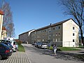
Apartment buildings "Neue Heimat"
_Erbauung_zwischen_1910_und_1938_%C3%84lter_als_Heimst%C3%A4ttensiedlung_2011-04-07.JPG)

_erbaut_1938-1940_von_der_Heimst%C3%A4ttensiedlungsgesellschaft_M%C3%BCnchen_im_Auftrag_der_Oberkohle_2011-04-07.JPG)
_Mietsh%C3%A4user_der_Oberkohle_erbaut_1950_-_1952.jpg)
Until the founding of the Penzberg parish in 1899, the Heinzenhof belonged to the Catholic parish of Antdorf .
| year | Residents | Buildings (from 1885 only residential buildings) |
|---|---|---|
| 1818 | 8th | 1 |
| 1825 | 7th | 1 |
| 1864 | 9 | 2 |
| 1871 | 12 | 6th |
| 1885 | 8th | 1 |
| 1900 | 199 | 17th |
| 1925 | 559 | 35 |
| 1950 | 512 | 37 |
| 1966 | 1205 | |
| 1970 | 1324 | |
| 1987 | 1131 | 173 |
Web links
- Heinz in the location database of the Bayerische Landesbibliothek Online . Bavarian State Library
Individual evidence
- ↑ a b Bavarian State Office for Statistics and Data Processing (Ed.): Official local directory for Bavaria, territorial status: May 25, 1987 . Issue 450 of the articles on Bavaria's statistics. Munich November 1991, DNB 94240937X , p. 159 ( digitized version ).
- ↑ Karl Luberger: history of the city Penzberg . Ed .: City of Penzberg. 1st edition. 1969, p. 13 .
- ↑ Reinhard Heydenreuter : History with a future. 100 years of the city of Penzberg in Upper Bavaria . Volk, Munich 2019, ISBN 978-3-86222-313-8 , pp. 49 f .
- ↑ Karl Luberger: history of the city Penzberg . Ed .: City of Penzberg. 1st edition. 1969, p. 99 .
- ↑ Karl Luberger: history of the city Penzberg . Ed .: City of Penzberg. 1st edition. 1969, p. 55 .
- ↑ Adolph von Schaden: Topographical-statistical manual for the Isar circle in the Kingdom of Baiern . 1825, p. 175 ( digitized in the Google book search).
- ^ Joseph Heyberger, Chr. Schmitt, v. Wachter: Topographical-statistical manual of the Kingdom of Bavaria with an alphabetical local dictionary . In: K. Bayer. Statistical Bureau (Ed.): Bavaria. Regional and folklore of the Kingdom of Bavaria . tape 5 . Literary and artistic establishment of the JG Cotta'schen Buchhandlung, Munich 1867, Sp. 332 , urn : nbn: de: bvb: 12-bsb10374496-4 ( digitized version ).
- ↑ Kgl. Statistical Bureau (ed.): Complete list of localities of the Kingdom of Bavaria. According to districts, administrative districts, court districts and municipalities, including parish, school and post office affiliation ... with an alphabetical general register containing the population according to the results of the census of December 1, 1875 . Adolf Ackermann, Munich 1877, 2nd section (population figures from 1871, cattle figures from 1873), Sp. 374 , urn : nbn: de: bvb: 12-bsb00052489-4 ( digitized version ).
- ↑ K. Bayer. Statistical Bureau (Ed.): Localities directory of the Kingdom of Bavaria. According to government districts, administrative districts, ... then with an alphabetical register of locations, including the property and the responsible administrative district for each location. LIV. Issue of the contributions to the statistics of the Kingdom of Bavaria. Munich 1888, Section III, Sp. 357 ( digitized version ).
- ↑ K. Bayer. Statistical Bureau (Ed.): Directory of localities of the Kingdom of Bavaria, with alphabetical register of places . LXV. Issue of the contributions to the statistics of the Kingdom of Bavaria. Munich 1904, Section II, Sp. 356 ( digitized version ).
- ↑ Bavarian State Statistical Office (ed.): Localities directory for the Free State of Bavaria according to the census of June 16, 1925 and the territorial status of January 1, 1928 . Issue 109 of the articles on Bavaria's statistics. Munich 1928, Section II, Sp. 370 ( digitized version ).
- ↑ Bavarian State Statistical Office (ed.): Official place directory for Bavaria - edited on the basis of the census of September 13, 1950 . Issue 169 of the articles on Bavaria's statistics. Munich 1952, DNB 453660975 , Section II, Sp. 347 ( digitized version ).
- ↑ Karl Luberger: history of the city Penzberg . Ed .: City of Penzberg. 1st edition. 1969, p. 196 .
- ^ Bavarian State Statistical Office (ed.): Official place directory for Bavaria . Issue 335 of the articles on Bavaria's statistics. Munich 1973, DNB 740801384 , p. 64 ( digitized version ).

Daser | Edenhof | Heinz | Johannisberg | Kirnberg | Maxkron | Nantes book | Neukirnberg | Nun forest | Oberhof | Penzberg | Promberg | Rain | Reindl | Sankt Johannisrain | Schönmühl | Vordermeir | Wölfl | Zachenried | Cist