
Obergrombach
|
Obergrombach
City of Bruchsal
|
|
|---|---|
 |
|
| Area : | 8.13 km² |
| Residents : | 2407 (December 31, 2018) |
| Population density : | 296 inhabitants / km² |
| Incorporation : | July 1, 1971 |
| Postal code : | 76646 |
| Area code : | 07257 |
 Obergrombach south of the core town of Bruchsal
|
|
 former synagogue at the city gate, today a residential building
|
|
Obergrombach is a former town and now a district of Bruchsal in the Karlsruhe district .
Geographical location
The 813 hectare area of Obergrombach lies on the edge of the Kraichgau and the Upper Rhine Plain on the banks of the Grombach . Karlsruhe is 15 kilometers southwest . The district roads K3501 and 3502 connect Obergrombach with its neighboring towns:
| Untergrombach | Bruchsal | Heidelsheim |
.svg)
|
Helmsheim | |
| Vineyard | Walzbachtal | Gondola home |
history

Settlement of the area goes back to at least the Neolithic Age (late 5th and 4th millennium BC): Traces of the Michelsberg culture were found on the Michaelsberg , two kilometers away , in 1884 . In 1911 a villa rustica from Roman times was discovered in the “Steinhaufen” area . Since then, the Obergrombach area has evidently been permanently inhabited, and the first settlement was probably founded at the time of the Merovingians . From 1936 to 1938 a large row grave field with 280 graves from the 6th / 7th centuries was established in the Gewann Danzberg. Excavated in the 16th century. The settlement was first mentioned in documents in 789 as villa Grumbach or Grunbahe .
Around the year 1200 AD, the Speyer Monastery , to whose sphere of influence Obergrombach apparently belonged since the 11th century, initiated the construction of a small castle east of today's town center. The Obergrombach castle probably served to control an old mountain trail from Pforzheim via Jöhlingen to Bruchsal and to secure political rule in the Grombachtal. A distinction was only made between Untergrombach and Obergrombach from 1275 onwards. While Obergrombach is still referred to as a village in 1313, it is first mentioned as a "town" in 1337, after the settlement was probably fortified with a city wall by the Speyer bishop Emich von Leiningen (tenure 1314–28) . In 1502 the attack by the Bundschuh movement , led by Joß Fritz from Untergrombach, failed . In 1632 the Jewish cemetery in Obergrombach was laid out. The castle was besieged several times during the Thirty Years' War and destroyed in 1689 or 1690 by the French in the Palatinate War of Succession or by an accidental fire. The castle was set up by Damian Hugo Philipp von Schönborn-Buchheim as a summer residence and the outer castle with buildings from the 16th and 17th centuries was repaired and expanded into a castle in the 1720s. Until the 18th century, Obergrombach was largely characterized by small-scale agriculture, with viticulture playing a minor role . The first synagogue was built in Obergrombach in 1790 and was used until the former Catholic chapel and parish church of St. Martin passed into the possession of the Jewish community in 1846. The castle has been owned by the Bohlen und Halbach family since 1885 . With the dissolution of the Jewish community in 1888, the synagogue was sold to the castle owners and converted back into a Christian chapel. Obergrombach was incorporated into Bruchsal on July 1, 1971 together with Untergrombach .
Population development
In 1530 the population was about 300 people. In 1636 it had fallen to 157 people and rose to almost 500 people by 1750. From 1850 to 1910 the population remained largely constant between 800 and 1000 people. In the 1960s, over 2000 inhabitants were counted for the first time. Census results showed between 1950 and 1970 a proportion of Catholics of over 90 percent. Between 2005 and 2018 the population was between 2,400 and 2,500, in 2018 it was 2407.

politics
Local council
In accordance with the Baden-Württemberg municipal code, a local council consisting of 10 people was set up in Obergrombach (as of January 2020).
coat of arms
The blazon of the coat of arms reads: "Standing in blue on a golden crescent moon, a golden crowned Madonna in a red robe surrounded by a golden halo, on the left the golden nimbly child Jesus, in the right holding a golden scepter."

coat of arms
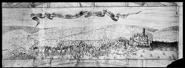
View of Obergrombach from the south,
engraving by Johann Dietrich Haeckhern, 1749
Map of the district, printed in 1879
.jpg)

Buildings

- Obergrombach Castle and Palace
- Remains of the city wall
- Two former synagogues in Obergrombach , now privately owned as a residential building and castle chapel
- Baroque town hall from 1788, a listed building
- Catholic Church of St. Martin, built in neo-Gothic style between 1840 and 1844 with organ from the company Weise and bell from the company Friedrich Wilhelm Schilling
- Brunnenstrasse 8 , half-timbered house from 1702

Back of the former synagogue now used as a residential building

The castle chapel above the Grombach spring

Brunnenstrasse 8

Burgstrasse 12

Grombach spring next to the castle chapel

Gravestone in the Obergrombach Jewish cemetery


.jpg)
Economy and Infrastructure
In 1965 the castle school was built. The on- site shooting range , which is used by the Bundeswehr units stationed in the General-Dr.-Speidel barracks , is located on the northern boundary of the town , and immediately next to it is the Obergrombach Jewish cemetery . To the northeast of the village is the cemetery with morgue and a festival area with a festival hall built as a “youth and community center” with funds from the Marshall Plan , now a restaurant. To the east of the village there is a campsite and an outdoor swimming pool . In contrast to the neighboring town of Untergrombach , the town does not have a rail connection.
Web links
Individual evidence
- ↑ a b Bruchsal figures, data, facts , see map. Website of the city of Bruchsal. Retrieved January 8, 2020.
- ↑ a b Resident population and information on the districts . Website of the city of Bruchsal. There are also 231 people with a secondary residence in Untergrombach.
- ↑ Britta Rabold : Roman villa, Bruchsal-Obergrombach (KA) . In: Dieter Planck: The Romans in Baden-Württemberg: Roman sites and museums from Aalen to Zwiefalten . Konrad-Theiss-Verlag, 2005, pp. 55–56.
- ↑ a b c d e f g h i Arnold Scheuerbrandt: Obergrombach . In: Historical Atlas of Baden-Württemberg , IV-07 Outlines of Medieval Cities II , 1977. See also the associated map .
- ^ A b c d e Baden-Württemberg regional information system (LeoBW): Obergrombach - Altgemeinde ~ sub-town .
- ↑ Obergrombach . Website of the city of Bruchsal. Retrieved January 8, 2020.
- ^ Burg Obergrombach: Medieval castle and modern palace . www.burgen-web.de. Retrieved January 8, 2020.
- ^ Federal Statistical Office (ed.): Historical municipality directory for the Federal Republic of Germany. Name, border and key number changes in municipalities, counties and administrative districts from May 27, 1970 to December 31, 1982 . W. Kohlhammer, Stuttgart / Mainz 1983, ISBN 3-17-003263-1 , p. 473 .
- ↑ Population development: Obergrombach . leograph-bw.de. Retrieved January 9, 2020.
- ↑ Religion: Obergrombach . leograph-bw.de. Retrieved January 9, 2020.
- ↑ Bruchsal residents - Obergrombach . Website of the city of Bruchsal. Retrieved January 8, 2020.
- ^ Local councils and local council Obergrombach . Website of the city of Bruchsal. Retrieved January 8, 2020.
- ↑ Obergrombach coat of arms . Website of the city of Bruchsal. Retrieved January 8, 2020.
- ^ The synagogue in Obergrombach near Alemannia Judaica
- ^ Christian Schweizer: Obergrombach: Inauguration ceremony for the renovated town hall . kraichgau.news, November 30, 2016.
- ↑ German Foundation for Monument Protection (ed.): Open Monument Day 2016 , p. 102.
- ↑ The organ of the parish church of St. Martin Obergrombach , Catholic parish Bruchsal Michaelsberg, accessed on January 8, 2020.
- ↑ Catholic parish church of St. Martin in Bruchsal-Obergrombach . Website of the Archdiocese of Freiburg, accessed on January 8, 2020.
- ↑ The castle school introduces itself . www.burgschule-obergrombach.de. Retrieved January 8, 2020.
- ↑ Heike Schwitalla: How Obergrombach got a meeting place from the USA: rediscovered bronze plaque attached to old place . www.wochenblatt-reporter.de, July 19, 2018.
- ^ Christian Schweizer: "Grombacher Stuben": Lost bronze plaque hung up again . kraichgau.news, July 10, 2018.