Oberschlierbach (municipality of Oberschlierbach)
| Oberschlierbach ( scattered houses ) ( capital of the municipality ) | ||
|---|---|---|
|
|
||
| Basic data | ||
| Pole. District , state | Kirchdorf an der Krems , Upper Austria | |
| Pole. local community | Oberschlierbach ( KG Oberschlierbach ) | |
| Locality | Oberschlierbach | |
| Coordinates (K) | 47 ° 56 '6 " N , 14 ° 10' 42" E | |
| height | 766 m above sea level A. | |
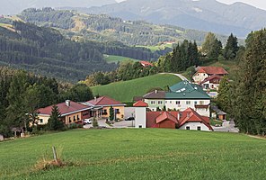
 View over the community center, in the back left the Grillenparz |
||
| 4 addresses Oberschlierbach (community center) Source: STAT : Place directory ; BEV : GEONAM ; DORIS ;
(K) Coordinate not official
|
||
Oberschlierbach is a locality in the Traunviertel of Upper Austria as well as the capital and locality of the Oberschlierbach municipality in the Kirchdorf an der Krems district .
geography
|
Oberschlierbach locality |
|
|---|---|
| Basic data | |
| Pole. District , state | Kirchdorf an der Krems (KI), Upper Austria |
| Judicial district | Kirchdorf an der Krems |
| Pole. local community | Oberschlierbach |
| Coordinates | 47 ° 55 '29 " N , 14 ° 9' 53" E |
| height | 760 m above sea level A. |
| Residents of the village | 745 (January 1, 2020) |
| Post Code | 4554 Oberschlierbach |
| Statistical identification | |
| Locality code | 09760 |
| Counting district / district | Oberschlierbach (40 911 000) |
| ZH Oberschlierbach with Eckelsberg , Haslach , approx. 90 addr. Source: STAT : Local directory ; BEV : GEONAM ; DORIS |
|
The place is located around 5 kilometers northeast of Kirchdorf an der Krems . The scattered settlement lies on the ridge of the eastern Almtaler and Kirchdorfer Flyschberge , between the Grillenparz ( 842 m above sea level ) above the Kremstal and the Eckelsberg ( 841 m above sea level ), over to the Steyrtal . It lies at around 760 m above sea level. A. Height. On the Schieferstraße ( L1324 , Kirchdorf – Untergrünburg / Steinbach) is the small community center with the 4 addresses Oberschlierbach, south of it the slate estate with chapel.
The village of Oberschlierbach is spread over the ridges around the upper Ellersbach , a tributary of the Krems, and its tributary, the Holzbach . It includes the hamlet of Haslach in the west above Schlierbach , the houses Wörtnerberg between Holzbach and Ellersbach, Am Hochkogel (Hochkogl) and Kaiserleithen in the northwest, as well as the addresses Schieferstraße , Schmiedberg and the community center on the main ridge, and then in the east the Rotte Eckelsberg . That’s around 90 addresses with around 750 residents (January 1, 2020: 745).
| Nussbach (O) | ||
| Beetle pit |

|
|
|
|
Hausmanning (O) ∗ |
|
- ∗The location of Hausmanning i. e. S. is located on the Heindlmühlbach behind Heindlmühle, also a village in the Schlierbach community in the southwest
History, infrastructure and sights
The area belonged to the parish of Kirchdorf from ancient times and in 1784 it became part of the new Schlierbach parish . The name as such does not appear until 1812 in the Franciscan land registry for the tax community .
The slate was acquired in 1900 by the Cistercian monastery Schlierbach , here is the slate chapel, the local chapel, and the kindergarten. It is a listed building .
The street names have been around since 2012.
proof
- 40911 - Oberschlierbach. Community data, Statistics Austria .
- ↑ a b Oberschlierbach according to Statistics Austria: Place Directory 2001 - according to this designation, the main place is an attribute of a place ( village deviates according to DORIS, layer administrative boundaries: municipality capital , 2018).
- ↑ a b c street names. In: Bürgerinfo July 2012, updates , p. 2 ( entire issue, pdf , gemeinde-oberschlierbach.at).
- ↑ DORIS addresses and basemap.at are Hochkogl here , like the labeling of the ÖK (accessed October 10, 2018).
- ^ Peter Wiesinger: Place Name Book of the Province of Upper Austria. Volume 10, Verlag der Österreichischen Akademie der Wissenschaften, 2001, 7.2.8.8. Oberschlierbach , p. 67.
- ↑ Slate Chapel . Schiefergut website (schiefergut.wordpress.com, accessed October 10, 2018).
- ↑ Kindergarten . gemeinde-oberschlierbach.at (accessed October 10, 2018).


