Olonkinbyen
| Olonkinbyen | ||
|---|---|---|
|
|
||
| Coordinates | 70 ° 55 ′ N , 8 ° 43 ′ W | |
| Basic data | ||
| Country | Norway | |
|
Extra-territorial area of Norway |
Jan Mayen | |
| ISO 3166-2 | NO-22 | |
| Residents | 18th | |
| Exclusively station staff | ||
|
Weather and radio station Olonkinbyen
|
||
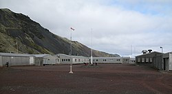
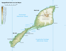
Olonkinbyen is the only settlement on the Norwegian island of Jan Mayen in the Greenland Sea . It consists of a combination of a weather station, military post and the operating team of the transmitter of the radio navigation system LORAN-C . The place is named after the polar explorer Gennadi Olonkin .
The settlement
Olonkinbyen consists of a few, mostly structurally connected buildings grouped around two inner courtyards open to the west and is located on the narrow coastal strip about 150 m inland on the south-east coast in the southern part of the island, in the lee of the ridge rising to a height of over 750 m, which runs through the southern part of the island. In Olonkinbyen the entire population of the island, living the in the 1960s nor of the up to 40 people, today a total of 18 men and women existing and every six months the exchanged personnel maintained by Norway weather station and for nautical and aviation - Navigation " Long Range Navigation " (LORAN-C) base operated for the purposes of this . The majority of the station personnel working on the Norwegian Armed Forces operated radio navigation station , the other (mostly meteorologists ) at the weather station of the Norwegian Meteorological Institute . Specialists such as nurses and cooks are also part of the permanent staff. Personnel changes take place in April and October. Station chief is a Norwegian officer who is the only one who stays on the island for a year.
history
Eldste Metten
The first weather station was set up by the Norwegian Meteorological Institute in 1921 on the shore on the east side of the island in Jameson Bay, a little east of the Eggøya peninsula . The corresponding coast station , Jan Mayen Radio , in particular, fishing vessels and sealers used consisted of a Telefunken - transmitter with three kilowatts of transmit power and a 55-meter antenna tripod mast . The station was operated by only three, later four men.
In September 1940 this station, subsequently called Eldstemetten (also Eldste Metten , Elder Met), was made unusable by the Norwegian armed forces and abandoned due to the war . However, since weather reports from Jan Mayen were of considerable importance for the Allied warfare, a new station was built some distance from the coast in Jøssingdalen in March / April 1941. A small military garrison with some anti-aircraft guns was added to her for protection . The German Wehrmacht very quickly became aware of the radio reports from the station and tried repeatedly, but without success, to eliminate it by attacking it with aircraft; these attacks were stopped in the course of 1941.
Gamle Metten
1943 directed the US Coast Guard at the North Lagoon on the northwest side of the island, not far from the Norwegian station, its own station, "Atlantic City" called for military surveillance of German radio traffic , which she ran until February 1946th After the Americans left, the Norwegians took over their buildings and used them as a provisional weather station until 1949. Then they built a better system right next to it, which remained in use until 1962; it is known today as Gamle Metten (old mead).
Metten
The Gamle Metten was exposed to the often very strong storms that fell from the glaciated slopes of the 2277 m high Beerenberg . Since a new building would have been necessary anyway, it was abandoned in 1962 and relocated to Olonkinbyen, which was built from 1958 on the south-west side of Jan Mayen as a LORAN base of NATO and had been in operation since 1959. The situation there was more protected and it made logistical sense to only supply and operate one station. The actual weather station, today's Metten , was installed about 3 km further northeast ( 70 ° 56 ′ 22.6 ″ N , 8 ° 40 ′ 4.1 ″ W ) on Helenesanden near the landing strip .
present
In 1984 the telegraphic installation was removed and the weather and coastal radio station was combined with the military system. An ultra-short wave transmitter was installed at Danielsen crater in 1989 and a medium wave transmitter in 1994 , which are controlled by Bodø Radio in Bodø .
The LORAN-C station belongs to the transmission chain 7001 Bø (Northern Europe) of the Northwest European LORAN-C System (NELS) . The transmitting antenna is located on a 190 meter high, guyed steel lattice tower, which is also some distance south of the small housing estate ( 70 ° 54 ′ 51.5 ″ N , 8 ° 43 ′ 56.5 ″ W ).
Airfield

The Norwegian Air Force maintains a 1585 m long unpaved runway , the Jan Mayensfield ( IATA : ZXB, ICAO : ENJA) , about 3 km northeast of the station ( 70 ° 56 ′ 42 ″ N , 8 ° 39 ′ 4 ″ W ). that is used by the Air Force to supply the station and is not accessible to general air traffic. Normally there is a flight to the island from Bodø once every six weeks . Since no instrument landing is possible, good visibility is required and the planes often have to take the two-hour flight back to Bodø without having landed.
Under certain weather conditions, the 2277 m high Beerenberg in the north of the island induces lee waves called " Kármán wind " , which can be felt on the lee side up to a distance of several hundred kilometers at a wavelength of up to 15 kilometers and which can endanger air traffic ; For example, a Lockheed C-130 “Hercules” almost crashed in 1991 due to a sudden “Kármán Shift” during take-off.
Web links
- Weather statistics from Olonkinbyen, at yr.no (English / Norwegian)
- LORAN-C long wave transmitter mast. In: Structurae
- Olonkinbyen (aerial photos) at www.jan-mayen.no
- Photos from the inside of the station at www.jan-mayen.no
- Website with more photos
- The weather station, Luftwaffe photo 2007
Notes and individual references
- ↑ Olonkin was a radio operator and mechanic on Roald Amundsen's ship Maud from 1918 to 1925 . He acquired Norwegian citizenship, worked for the Norske Meteorologisk Institute and was involved in the expansion of the LORAN station on Jan Mayen from 1958.
- ↑ a b World Atlas and Country Lexicon. Tandem-Verlag GmbH
- ↑ Met = colloquial abbreviation for Meteorological Station.
- ^ Susan Barr: Past and Present Infrastructure of Jan Mayen as Historical Documents . The Fate of Anthropogenic Remains. In: Stig Skreslet (Ed.): Jan Mayen Island in Scientific Focus . NATO Advanced Research Workshop, Oslo, November 11-15, 2003. Kluwer Academic Publishers, 2004, ISBN 978-1-4020-2956-1 , pp. 239–247 ( limited preview in Google Book search).


