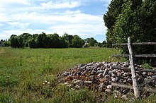
Paelda
Coordinates: 58 ° 37 ' N , 23 ° 12' E
Päelda (German Päedla ) is a village ( Estonian küla ) on the third largest Estonian island of Muhu . It belongs to the rural community of the same name ( Muhu vald ) in the Saare district ( Saare maakond ).
Population
The place has twelve inhabitants (as of December 31, 2011).
In Päelda is the highest point on the island of Muhu, 25 meters above sea level, the Sepa mägi .
Castle Hill
To the east of the village center was a small fortress of the pagan Estonians . It was surrounded by an oval ring wall made of round granite stones about one meter high and seven to eight meters wide . The largest diameter was about 70 meters.
The system can hardly be made out in today's landscape. No archaeological finds were made.
literature
- Baltic historical local dictionary. Part 1: Estonia (including Northern Livonia). Started by Hans Feldmann . Published by Heinz von zur Mühlen . Edited by Gertrud Westermann . Böhlau, Cologne / Vienna 1985 (= sources and studies on Baltic history. Volume 8/1), ISBN 3-412-07183-8 , p. 418.
Web links
Commons : Päelda fortress - collection of images, videos and audio files
- History of the place (Estonian)


