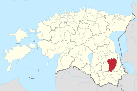
Põlva (municipality)
| Põlva | |||
|
|||
| State : |
|
||
| Circle : |
|
||
| Coordinates : | 58 ° 4 ' N , 27 ° 3' E | ||
| Area : | 706 km² | ||
| Residents : | 14,600 (01/01/2014) | ||
| Population density : | 21 inhabitants per km² | ||
| Time zone : | EET (UTC + 2) | ||
| Telephone code : | (+372) 0799 | ||
| Postal code : | 63308 | ||
| Mayor : | Georg Pelisaar | ||
| Postal address : | Kesk 15 Põlva |
||
| Website : | |||

|
|||
Põlva (dt. Pölwa , est. Põlva vald ) is a municipality and capital of the Estonian district of Põlva with an area of 234 km². It has 9,459 inhabitants (as of January 1, 2014).
The municipality is a member of the European Charter - Villages of Europe , a group of rural municipalities from all 28 EU countries.
geography
The center of the municipality, the city of Põlva , was incorporated in 2013. Vardja järv lies in the area .
structure
In addition to the town of Põlva , which was incorporated in 2013, the rural community consists of the villages Aarna , Adiste , Himmaste , Holvandi , Kähri , Kiuma , Lutsu , Mammaste , Meemaste , Metste , Miiaste , Naruski , Nooritsmetsa , Orajõe , Partsi , Peri , Puskaru , Puuri , Rosma , Soesaare , Tännassilma , Taevaskoja , Tromsi , Uibujärve , Valgesoo and Vanaküla .
Sports
The area along the Ahja river near Taevaskoda is interesting for nature lovers . In winter, numerous winter sports enthusiasts use the partially illuminated trails at Mammaste for cross-country skiing . They are located near the village of Orajõe in the glacial valley along the Orajõgi River . In the center is the Mammaste Sports and Health Center ( Mammaste Tervisespordikeskus in Estonian ).
See also
Web links
- Website of the municipality of Põlva (Estonian and English)
- Hiking in Taevaskoda

