Pagadian
| Pagadian City | ||
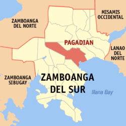
| Location of Pagadian in the province of Zamboanga del Sur | ||
|---|---|---|

|
||
| Basic data | ||
| Region : | Zamboanga Peninsula | |
| Province : | Zamboanga del Sur | |
| Barangays : | 54 | |
| District: | 1. District of Zamboanga del Sur | |
| PSGC : | 097322000 | |
| Income class : | 2nd income bracket | |
| Households : | 28,027 May 1, 2000 census
|
|
| Population : | 199.060 August 1, 2015 census
|
|
| Population density : | 596.3 inhabitants per km² | |
| Area : | 333.8 km² | |
| Coordinates : | 7 ° 49 ′ N , 123 ° 20 ′ E | |
| Postal code : | 7016 | |
| Area code : | +63 62 | |
| Mayor : | Samuel "Sammy" S. Co (NPC-KAMPI) | |
| Website: | www.pagadian.gov.ph | |
| Geographical location in the Philippines | ||
|
|
||
Pagadian City is a second- income city in the Zamboanga del Sur Province of the Philippines . It is the capital of this province and the district center of the entire District IX, Zamboanga Peninsula .
The city's nickname is "Little Hong Kong of the South".
Pagadian City is the seat of the Pagadian Diocese .
Origin of name
The first Christian settlers were Spanish soldiers and their families who were stationed on Dumagoc Island, an island in Illana Bay off the coast of what is now Pagadian City. Since many of them died of malaria and the rest of the people were afraid of this and other diseases, the place was soon referred to as “PANGADYE-AN”, a place “to be prayed for”.
Another version of the origin of the name of the city says that a group of settlers from Luzon reached the unknown place on the Zamboanga peninsula. There they met locals and asked them for the name of the place. But they did not understand a word of the dialect they did not know. After the newcomers asked the question, they pointed their heads up, probably to point to the land ahead. With a flock of birds flying by, the locals related the question to the flock above them. So they gave the strangers the name of the birds, “GAGADIAN”, which was either not properly understood by them or changed to Pagadian over time .
geography
Pagadian City is located on the northeast side of the Zamboanga del Sur Province. It is surrounded by the administrative communities of Midsalip in the north, Labandan in the northwest and east, Lakewood in the west and Dumalinao in the southwest. In the south lies the coastline to the Bay of Illana , part of the Gulf of Moro .
In the north and west, the landscape is characterized by hilly, partly mountainous sections. At 209 m, Mount Palpalan is located at the intersection between the Lanao-Pagadian-Zamboanga City road and the municipal boundary of Dumalinao, west of the city limits. Mount Begong near Baranggay La Suerte has a summit height of 235 m above sea level, Mount Pinukis is 396 m high and Mount Sugar Loaf Lison Valley is the highest point in the area at 437 m. The south and east, on the other hand, are largely flat and characterized by agricultural use.
In the urban area, four rivers flow into Pagadian Bay, part of Illana Bay : the Balangasan River, Gatas River, Bulatoc River, and Tiguma River. Another river, the Labangan River, flows through the rural areas and flows directly into Illana Bay .
Barangays
Pagadian City is politically divided into 54 barangays .
|
|
|
history
Originally, Pagadian was a barrio (district) of the administrative municipality of Labangan, which was part of the then Zamboanga province. On March 23, 1937, the former district was awarded Executive Order No. 77 converted to a separate administrative municipality.
Pagadian finally became a chartered city on June 21, 1969 with Republic Act No. 5478, also known as the Pagadian City Charter Paper.
When the Zamboanga Province was divided into two provinces, Zamboanga del Norte and Zamboanga del Sur , Pagadian City was named the capital of the second province on September 17, 1952.
As early as 1990, during the tenure of President Corazon Aquino , attempts were made to move the administrative center of District IX Zamboanga Peninsula from Zamboange City to Pagadian, but this proposal could not be implemented at the time. In 2004, however, President Gloria Arroyo ordered all government departments to be transferred to Pagadian, with the exception of the Tourism Office, the Labor Office, and the Trade and Industry Office, which remained in Zamboanga City .
The move of the district administration to Pagadian City, which may have been carried out with the aim of making the city one of the most important hubs in the southern Philippines, is not without controversy. Many people in Zamboanga City believe that the move is not least a punishment for not supporting Gloria Macapagal-Arroyo's last presidential campaign. The relocation remains questionable due to the much larger population of Zamboanga. Zamboanga also has flight connections to Cebu , Manila and Malaysia . Zamboanga City is also a major economic and transportation hub in West Mindanao.
Attractions
Sights include:
- White Beach
- The Lison Valley Falls
- Ditoray Falls in the suburb of Ditoray
- Mount Susung Dalaga in the suburb of Lison Valley
Web links
- elgu.ncc.gov.ph - Pagadian City ( Memento of November 10, 2004 in the Internet Archive )
- Origin of names and geography on pagadian.com ( Memento from December 10, 2008 in the Internet Archive )
