
Pangeo
| Pangeo (Pangaion) | ||
|---|---|---|
 North side of Pangeo from Philippi seen from |
||
| height | 1956 m | |
| location | North Greece | |
| Mountains | Greek Rhodope Mountains | |
| Coordinates | 40 ° 55 '0 " N , 24 ° 20' 0" E | |
|
||

Pangeo ( Neugriechisch Παγγαίο [ paŋgʲɛɔ ] or Παγγαίο όρος PANGEO Óros , n. ; Ancient Greek Παγγαῖος Pangaîos , m. , Παγγαῖον [ὄρος] Pangaion [Óros] or Πάγγαιον [ὄρος] Pangaion [Óros] , N .; German also Pangaios, Pangaeum , Pangeon ) is the name of a mountain range in Northern Greece as well as its highest point with 1956 m . It is part of the Greek Rhodope Mountains and lies to the west of Kavala , between the Strymon and Xiropotamos rivers . It can be assumed that the term Pangaion in antiquity and antiquity meant the three mountain ranges Pangaion, Symvolon and Lekanis between Strymon and Nestos mentioned today as a whole.
Mythology and history
According to Greek mythology , Lycurgus was killed by wild horses on Mount Pangaion . Orpheus is said to have prayed to Apollo here every morning . The legendary wealth of the Kadmos is said to have come from the rich gold and silver deposits of the Pangaion.
In fact, the precious metals have been exploited since early antiquity by the Thracian tribes resident here , the Edons , Pierers , Odomanten and especially the Satren . In the 7th century BC BC the Thasites managed to establish themselves on the nearby mainland. They established trading posts and brought the mines under their control. The Thasitian Peraia was created . From Herodotus to be under the name Skapte Hyle described the "gold and silver mines" in the "big and tall" Pangaiongebirge. Athens too reached out for the rich gold deposits: since an expedition by Kimon in 463 BC. The Pangaion was under Athenian hegemony.
Philip II brought in 357 BC With the conquest of Amphipolis also the rich mines of Pangaion under the rule of Macedonia . These mountains play a fateful role in the history of Macedonia: The last Macedonian king Perseus wanted to drive the Thracian prince Abrupolis from here, but in doing so he gave the Romans a reason for the war that became his downfall.
Mining and metal extraction
In the 1950s and 1960s numerous ore deposits were identified and examined in the area of the Thasitian Peraia , and prospecting for soap gold in the 1970s . During explorations at the Ephoria Kavala , extensive mining facilities, remains of ore processing and smelting facilities and extensive heaps of metallurgical slag were found . Gold and silver were found in mineralogical investigations. Archaeometallurgical analyzes showed that metallurgical products such as gold and silver were exported from the Pangaion.

With funds from the Fritz Thyssen Foundation , the geologist Heinz-Josef Unger, Geological State Office Munich, and the business economist Ewald Schütz carried out investigations in the Pangaion in 1976 and 1980 with the aim of evaluating the geological and mining situation. In the reports drawn up, it was found that significant mining and smelting activities can be identified in the central and eastern Pangaion. In 1990 the Ephoria Kavala only mentions the remains of ore processing and smelting facilities , as well as metallurgical slag heaps in the northeast of the mountains. She doubts the connection of the Pangaion with the famous, rich gold mines of Skapte Hyle .
On the basis of their investigations, Unger and Schütz came to the conclusion that some of the mines and smelting sites explored may already date from the end of the Neolithic . The heyday of the activities there is believed to be in the Late Bronze and Iron Ages . Another heyday, in which the mining fields had reached their greatest extent and the yield reached the highest level, occurred in the period between 700 and 200 BC. It is very likely that mining in Pangaion was also carried out in Roman and Byzantine times. The heyday of activities is assumed in the Bronze and Iron Ages as well as in the Classical , Hellenistic and Byzantine periods.
The mountains are littered with slag heaps and marked by an unprecedented number of pings and broken tunnels. Geologically it is in Pangaion generally a alternation of marble , mica schists , amphibolites , gneiss and igneous granodiorite - intrusions . In connection with strong fracture tectonics, a probably two-phase vein mineralization occurred. Thick pyrite- bearing gold quartz veins , as well as mineralization of copper, lead, zinc, silver, bismuth - pale ores could be determined.
Moustheni

The southernmost mining area in the central Pangaion was established east of Moustheni on the western slope of the Tsali. Boulders that have fallen from the steep walls of the Tsali show recognizable traces of mining. Several tunnel mouth holes were clearly identified. Mining focused on pale ores and gold. North-northwest of Moustheni, slag heaps and old mining could be detected as early as 1967 at an altitude of 1000 m .
Agia Analipsis
In the area of the Agia Analipsis monastery, two gold quartz veins strike out, which extend into the high valleys north and south of the mountain “1927”, named after its height. Three slag heaps and two tunnel mouth holes were found here. The two gold quartz veins with up to 5 m thick were open pit , possibly underground in tunnel construction ausgeerzt so deep Taleinschnitte and sinkholes emerged. On the basis of the iron-arsenic flakes found , it can be assumed that, in addition to gold and silver ores, pale ores were also smelted here. The Agia Analipsis mining area is likely to have been the second largest mining area in the Pangaion after the one discovered on Mount Mati.
High valleys east of Analipsis
The southern or first high valley (1500 to 1740 m ) was again cleared in an open pit. Shaft A in the west of the high valley is noteworthy with a cross-section of 10 × 10 m, a carved entrance and a depth of more than 20 m. Starting from the shaft, tunnels can be traced along the corridor on both sides .
Up to 50 m wide sinkholes can be seen , which reveal manholes and tunnel mouth holes in the depths. On the northern walls of the valley there are further tunnel approaches, including covered mine dumps. In the mining area, various settlement areas can be identified by building remains and rich ceramic finds. A clearly identifiable mining area (1460 to 1600 m ) runs through the northern or second high valley . Here, at the foot of the northern slope of the mountain “1927”, four tunnel mouth holes and six slag heaps could be explored. In the alpine area there was again a settlement area with ceramic artifacts.
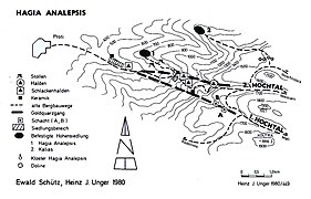
The gold quartz veins around Agia Analipsis

Mining and smelting in the first high valley

Mining and smelting in the second high valley
Mining and smelting on the Mati


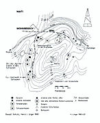
Mati

The western and northern flanks of the Mati ( 1835 m ) are littered with mighty, partly heavily covered slag heaps, mountain heaps, and rock heaps, many open-cast mine cuttings, and broken and buried tunnel mouth holes. The slag in the north suggests the smelting of pale ores, in the west of copper ores. A deep tunnel could also be explored in the southern flank of the Mati. It is very likely that the quarrying expanded around the summit of the Mati and also extended into areas down the valley. Numerous ceramics were found in the Klaubehalden in the north of the Mati. The quarries and smelting sites on the Mati, which so far could only be partially explored, are likely to represent the largest mining center of the Pangaion alongside those around Hagia Analepsis.
Nikisiani-Palaiochori
In the northeast of the Pangaion, near the villages of Palaiochori and Nikisiani, Unger and Schütz took up around 18 slag heaps and considerable structural remains of ore washing plants. No ore mining could be discovered in the immediate vicinity. In 1400 to 1460 m above Nikisiani and Palaiochori, in the steep drop at Ag. Georgios discovered a large number of broken tunnel mouth holes with relatively large upstream mining heaps. There are also several tunnel mouth holes in the area of Kortokopi and Kouneri.
Fortified hill settlements and mining roads
The outstanding result of the explorations in 1976 and 1980 was the discovery, sketching and description of fortified hill settlements around the Pangaion, as well as an extensive network of trails. At an altitude of 300 to 600 m there are up to 15 fortified systems, from which mining and hut areas could be secured and monitored. Five of these systems were measured and sketched.
Tsali

A fortified settlement was assigned to mining. It is located on the steep mountain saddle between the summit of Tsali ( 480 m ) and 440 m . The large all-round fortified complex with a length of about 240 m and a width of about 180 m was evidently densely populated in the Late Bronze Age. For the attachment of the system several towers belong in the highest area, as well as at the lower end of the system a "Thracian" double wall with tower and gate (?) Up to 2.7 m thick. Another 250 m long front wall running transversely on the saddle between 420 and 390 m and partly still standing tall has a width of about 2.2 m and is called "Hellenistic-Byzantine". Building foundations carved out of the rock can be found between the double wall and the front wall. On the saddle spur to the south there is another fortified farm with an area of around 160 × 100 m. It is provided with a gate (?) And a tower towards the east. Overall, it appears to be a city-like fortification.

Palaiokastro

North of the location Palaiochori was 1976 hillfort of Paleocastro (555- 600 m mapped), which obviously was used by operators to control and supply of the treatment and smelters. No structural remains have yet been discovered on the upper plateau of the walled settlement of Palaiokastro. In the area following to the northwest there are foundations of several buildings. On the lower plateau , the remains of a castle, remains of a Byzantine chapel and a cistern were found on a hill ( 585 m ). In the outer wall, recognizable in the upstanding remains, is a tower in the north, and an access gate to the settlement in the southeast. The structural remains of walls and building foundations, stone setting of the surrounding outer walls were measured and shown in drawings. The access to the Palaiokastro was from the western end of the village of Palaiochori via a 1.1–1.3 m wide path that can be followed to the southeast corner of the complex. Palaiokastro dominated the valley of Palaiochori and also offered a good view of the Nikisiani valley. The entrances to both valleys from the Krenides / Philippi plain could be controlled.
- More hilltop settlements

Fortified hill settlements
Kortokopi I and II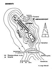
Fortified hilltop settlement on the Derbenti

Fortified hilltop settlement near Antiphilippi

Fortified hilltop settlement Kourneri
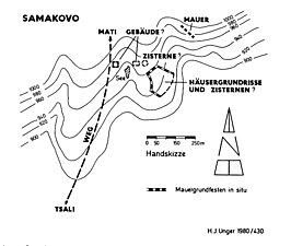
Samakovo hilltop settlement


Individual evidence
- ↑ Herodotus VII, 112.
- ^ Institute for Geology and Mineral Resources (IGEY): Ore deposits in Eastern Greece-Macedonia and Thrace .
- ^ Society for Geology and Mining (GEMEE): Seifengold in Greece .
- ↑ Chaido Koukouli-Chrysanthaki: Τα, μέταλλα 'της Θασιακής Περαίας ( Eng . "The, μέταλλα' of the Thasitian Peraia"). In: Πόλις και Χώρα στην αρχαία Μακεδονία και Θράκη ("City and Country in Ancient Macedonia and Thrace"). Report on the Archaeological Congress, Kavala 9. – 11. May 1986. Greek Ministry of Culture, Archaeological Museum Kavala and École Française d'Athènes, Thessaloniki 1990, pp. 493-532.
- ↑ PF Schenk: Geology of the western Pangaion in Greek East Macedonia. Supplement Geologisches Jahrbuch 88, 1970, pp. 81-132.
literature
- Heinz-Josef Unger, Ewald Schütz: Pangaion. Vol. 1: A mountain range and its mining: Myth and reality. Self-published, Landshut 1980.
- Heinz-Josef Unger, Ewald Schütz: Pangaion. Vol. 2: Hikes in the Pangaion: a mountain range and its mining. Self-published, Landshut 1981.
- Heinz-Josef Unger, Ewald Schütz: Pangaion - A mountain range and its mining. In: H. Geißlinger (Red.): Southeast Europe between 1600 and 1000 BC Chr. Moreland Ed., Bad Bramstedt 1982, pp. 145-172.
- Heinz-Josef Unger: The Pangaion, an old mining center in Eastern Macedonia. In: N. Bantelmann, B. Hansel, M. Müller-Wille (eds.): Prehistoric magazine. 62nd Volume (1987), Issue 1.