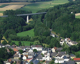
Schirndinger Pass
| Schirndinger Pass ( valley pass ) |
|||
|---|---|---|---|
|
View of the Schirndinger Pass (with the B 303 bridge) |
|||
| Compass direction | west | east | |
| height | 450 m above sea level NN | ||
| country | Bavaria , Germany | ||
| Waters | Röslau | ||
| Valley locations | Schirnding | Pomezí nO | |
| expansion | Bundesstrasse 303 ( E 48 ) / railway line Nürnberg – Cheb | ||
| Mountains | Fichtel Mountains | ||
| map | |||
|
|
|||
| Coordinates | 50 ° 4 '53 " N , 12 ° 13' 47" E | ||
The Schirndinger Pass is 450 m above sea level. NHN high valley pass in the east of the Selb-Wunsiedler plateau . It is located in the Röslau valley between Schirnding ( Upper Franconia ) and Pomezí nad Ohří ( Czech Republic ) on German territory.
geography
To the northeast of Schirnding is the breakthrough of the Röslau , known as the Schirndinger Pass , into the Eger basin . The federal highway 303 ( E 48 ) and the Nuremberg – Cheb railway line run parallel to this . The Röslau separates the Selber Forest (up to 688 m above sea level ) in the north from the Kohlwald (up to 656 m nm ) in the south. Just north of it, the Eger , whose breakthrough into the Eger Basin is too narrow for a passage, forms the border with the Czech Republic and shortly afterwards takes on the Röslau, which also forms the border there.
history
The naturally created east-west connection, the scenic gate along the Röslau, has been used as a transition from the Bohemian Basin to the Fichtel Mountains and vice versa for many centuries . The first reasonably historically founded fact should be the passage of Charlemagne .
The trade route "Via que procedit de Egire" from Nuremberg via Creußen to Eger, already mentioned in 1061, led through the pass. The old imperial , army and trade routes from Frankfurt am Main via Kulmbach , Gefrees , Weißenstadt and Eger to Prague also ran through the narrow landscape and shaped them and their residents.
Buildings
On the former border between the Principality of Bayreuth and the Kingdom of Bohemia there was an important fortification , Hohenberg Castle .
It stands on a rocky knoll that towers 125 meters above the Eger on the edge of the center of the town of Hohenberg an der Eger . The castle is now station two kilometers to the south of Bayreuth after Eger running Castle Road . The castle, located high above the Egertal, was after the Plassenburg ob Kulmbach the most important fortress in the Hohenzollern margraviate of Brandenburg-Kulmbach-Bayreuth and secured the Schirnding pass , which was once important in terms of transport and strategy .


