Peñaflor (Grado)
| Grado municipality: Parroquia Peñaflor | ||
|---|---|---|
| coat of arms | Map of Spain | |

|
|
|
| Basic data | ||
| Autonomous Community : |
|
|
| Comarca : | Oviedo | |
| Coordinates | 43 ° 24 ′ N , 6 ° 3 ′ W | |
| Height : | 51 msnm | |
| Area : | 8.57 km² | |
| Residents : | 261 (January 1, 2011) INE | |
| Population density : | 30.46 inhabitants / km² | |
| Postal code : | 33829 | |
| Area code: | 33026140000 | |
| Nearest airport : | Asturias Airport 28.5 km | |
| administration | ||
| Address of the municipal administration: | C /. Alonso de Grado, 3 - 33820 Grado | |
| Website : | www.ayto-grado.es//verpoblacion.asp?id=16 | |
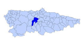
| Location of the municipality | ||

|
||
Peñaflor is a place and a parroquia in the municipality of Grado in the Autonomous Community of Asturias . The administrative seat of the municipality is Grado, 2.7 km away.
geography
The Parroquia with 261 inhabitants (as of 2011) is located at 51 m above sea level on the Río Nalón and is a stop on the original Way of St. James , the Camino Primitivo . Pleasantly mild but also damp summers alternate with mild winters.
The place Peñaflor is a street village . The Parroquia includes the following villages and hamlets :
- Anzo 49 inhabitants (2011) 43 ° 23 ′ 52 ″ N , 6 ° 1 ′ 52 ″ W
- Peñaflor 139 inhabitants (2011)
- Sestiello 38 inhabitants (2011)
- Vega de Anzo 35 inhabitants (2011) 43 ° 23 ′ 25 ″ N , 6 ° 0 ′ 53 ″ W
Festivals
The parish festival is celebrated on the 1st Sunday in August.
Attractions
- Romanesque parish church of San Juan
- several corn stores ( horreos ) in the neighborhood of the church
swell
- ↑ Brief description of the church ( Memento of the original from October 12, 2008 in the Internet Archive ) Info: The archive link was inserted automatically and has not yet been checked. Please check the original and archive link according to the instructions and then remove this notice.
- Population figures see INE
- Postcodes see [1]
- For coordinates and heights, see Google Earth
Web links
← Previous location: Puerma | Peñaflor (Grado) | Next town: Grado 3 km →
Oviedo | Lampajúa / Llampaxuga | Loriana | Escamplero | Valsera | Premoño | Paladín | Puerma | Peñaflor | Grado | San Juan de Villapañada | San Marcelo | La Doriga | Cornellana | Llamas | Quintana (Grado) | Casazorrina | Mallecín | Salas | Porciles | Bodenaya | La Espina | La Pereda | El Pedregal | Tineo | Piedratecha | Villaluz | Vega del Rey | Berrugoso | Campiello | Borres | La Mortera | Porciles | Ferroy | Pola de Allande | Puerto del Palo | Montefurado | (Texu de) Lago | Berducedo | La Mesa | Bus pole | Grandas de Salime dam | Grandas de Salime | La Farrapa | Cereijeira | Gestoselo | Peñafuente | Cabreira | Barbeitos | Fonfría (Fonsagrada) | Paradonova | Fonsagrada | Padrón | Vilardongo | Montouto | Paradavella | Degolada | A Lastra | Fontaneira | Cádavo Baleira | Pradera (Lugo) | Vaqueriza | Villabade | Castroverde | Souto de Torres | Vilar de Cas | Gondar (Lugo) | Carballido | Manzoi | Casas da Vina | Lugo | Seoane (Lugo) | San Vicente do Burgo | Mera de San Pedro | San Román da Retorta | Santa Cruz da Retorta | Villamayor de Negral | Palas de Rei |
