Pikeville (Tennessee)
| Pikeville | ||
|---|---|---|
 Pikeville city center |
||
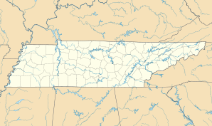
| Location in Tennessee | ||
|
|
||
| Basic data | ||
| Foundation : | 1911 (incorporated) | |
| State : | United States | |
| State : | Tennessee | |
| County : | Bledsoe County | |
| Coordinates : | 35 ° 36 ′ N , 85 ° 11 ′ W | |
| Time zone : | Central ( UTC − 6 / −5 ) | |
| Residents : | 1,608 (as of 2010) | |
| Population density : | 255.2 inhabitants per km 2 | |
| Area : | 6.3 km 2 (approx. 2 mi 2 ) | |
| Height : | 262 m | |
| Postal code : | 37367 | |
| Area code : | +1 423 | |
| FIPS : | 47-58120 | |
| GNIS ID : | 1297464 | |
 The Bledsoe County Courthouse in Pikeville, listed on the NRHP since 1995 |
||
Pikeville is a small town (with the status " City ") and the administrative seat of Bledsoe County in the US -amerikanischen State Tennessee . In 2010 Pikeville had 1608 inhabitants, the number of which increased slightly to 1612 by 2013.
geography
Pikeville is located in east Tennessee on the edge of the Cumberland Plateau . The city is located in the valley of the Sequatchie River , which is part of the Mississippi River basin across the Tennessee River and the Ohio .
The geographical coordinates of Pikeville are 35 ° 36'20 "north latitude and 85 ° 11'12" west longitude. The urban area extends over an area of 6.3 km².
Pikeville's neighbors are Cold Spring (7.8 km northeast) and Dayton (28.3 km southeast).
The closest major cities are Lexington , Kentucky (334 km north-northeast), Knoxville (149 km east-northeast), Chattanooga (78 km south), Tennessee's capital Nashville (195 km west-northwest), Bowling Green in Kentucky (251 km northwest) and Kentucky's largest city Louisville (233 miles north).
traffic
The US Highway 127 leads in northeast-southwest direction along the Sequatchie River through the city. In addition, the Tennessee State Routes 28 , 30 , 209 and 213 meet in the urban area of Pikeville. All other roads are subordinate country roads, some unpaved roads and inner-city connecting roads.
The nearest airport is Chattanooga Metropolitan Airport, 93 km south .
population
| Population development | |||
|---|---|---|---|
| Census | Residents | ± in% | |
| 1920 | 488 | - | |
| 1930 | 551 | 12.9% | |
| 1940 | 759 | 37.7% | |
| 1950 | 882 | 16.2% | |
| 1960 | 951 | 7.8% | |
| 1970 | 1454 | 52.9% | |
| 1980 | 2085 | 43.4% | |
| 1990 | 1771 | -15.1% | |
| 2000 | 1785 | 0.8% | |
| 2010 | 1608 | -9.9% | |
| 2013 estimate | 1612 | 0.2% | |
| 1920-2000 2010-2013 | |||
According to the 2010 census , Pikeville had 1,608 people in 665 households. The population density was 255.2 inhabitants per square kilometer. Statistically, 2.31 people lived in each of the 665 households.
The racial the population was composed of 93.6 percent white, 2.8 percent African American, 0.2 percent Native American, 0.1 percent (one person) Asian, 0.1 percent Polynesian and 2.0 percent from other ethnic groups Groups; 1.2 percent were descended from two or more races. Regardless of ethnicity, 3.6 percent of the population was Hispanic or Latino of any race.
22.8 percent of the population were under 18 years old, 56.3 percent were between 18 and 64 and 20.9 percent were 65 years or older. 53.7 percent of the population were female.
The average annual income for a household was 26,205 USD . The per capita income was $ 15,313. 29.3 percent of the population lived below the poverty line.
Known residents
- Josiah M. Anderson (1807–1861) - Whig - Member of the US House of Representatives (1849–1851) - was born and raised in Pikeville
- James B. Frazier (1856–1937) - 32nd Governor of Tennessee (1903–1905) - born in Pikeville
- Sam D. McReynolds (1872–1939) - Democratic Member of the US House of Representatives (1923–1939) - was born and raised in Pikeville
Individual evidence
- ↑ Extract from the National Register of Historic Places - No. 95000346.Retrieved December 17, 2014
- ↑ a b c American Fact Finder. Retrieved December 17, 2014
- ↑ Distance information according to Google Maps. Accessed on December 17, 2014
- ↑ United States Census Buero - Census of Population and Housing.Retrieved December 17, 2014

