Pniów (Toszek)
| Pniów | ||
|---|---|---|

|
|
|
| Basic data | ||
| State : | Poland | |
| Voivodeship : | Silesia | |
| Powiat : | Gliwicki | |
| Gmina : | Toszek | |
| Geographic location : | 50 ° 26 ' N , 18 ° 36' E | |
| Residents : | 644 (2008) | |
| Postal code : | 44-120 | |
| Telephone code : | (+48) 032 | |
| License plate : | SGL | |
| Economy and Transport | ||
| Next international airport : | Katowice | |
Pniów ( German Pniow ) is a village in Upper Silesia in the municipality of Toszek (Tost) in the powiat Gliwicki of the Silesian Voivodeship in Poland .
geography
Geographical location
Pniów is located seven kilometers southeast of the township seat Toszek , 16 kilometers northwest of the district town Gliwice (Gleiwitz) and 34 kilometers northwest of the voivodeship capital Katowice .
Neighboring places
Neighboring places of Pniów are in the north Zacharzowice (Sacharsowitz) , in the south Pyskowice (Peiskretscham) and in the southwest Paczyna (Groß Patschin) .
Districts
- Srocza Góra (Elsterberg)
history
The place was first mentioned in a document in 1256. In 1305 it received German law. The scrap wood church was built in 1506. The church has been a branch church of Groß Patschin since 1735 . In 1865 the place had 10 farmers, 4 half-farmers, 17 outdoor gardeners and 2 cottagers, and a Catholic school with 96 pupils is also mentioned.
In the referendum in Upper Silesia on March 20, 1921, 138 eligible voters voted to remain with Germany and 204 for Poland. Pniow remained with the German Empire . In 1933 there were 795 inhabitants. On February 12, 1936, the place was renamed Schrotkirch . In 1939 the place had 772 inhabitants. Until 1945 the place was in the district of Tost-Gleiwitz .
In 1945 the previously German place came under Polish administration and was renamed Pniów and joined the Silesian Voivodeship. In 1950 the place came to the Katowice Voivodeship . In 1956 the scrap wood church burned down. The new church building was built from 1957 to 1959. In 1999 the place came to the re-established Powiat Gliwicki and the new Silesian Voivodeship .
Sights and monuments
There are several historical buildings, sights and monuments in Pniów:
- Modern church from the years 1957 to 1959. It was built to replace the scrap wood church from 1506 that burned down in 1956. The Schrotholzkirche was one of the oldest in Upper Silesia.
- Gröling family cemetery chapel, built around 1770
- Half-timbered customs office building from 1870
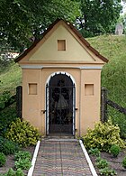
- Pathway chapel from the first half of the 19th century with a figure of St. Nepomuk
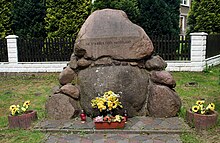
- Fallen memorial - For the fallen soldiers of the First World War, made of field stones. Erected in 1932 and rebuilt in 1989 after its destruction.
- Memorial stone for the 750th anniversary of the town
- Wayside cross from 1887
- Wayside cross from 1934
- Ruins of the castle and the farm buildings and overgrown castle park with a size of 1.5 hectares. The baroque style castle was built in 1770 for the von Gröling family. It was rebuilt in 1840 and 1880.
- There is an approx. 170 year old exotic tree of the species Retinospora plumosa and three oaks with a circumference of 320 cm, 431 cm and 475 cm.
education
- a primary school.
Web links
Individual evidence
- ↑ a b Website of the municipality ( page no longer available , search in web archives ) Info: The link was automatically marked as defective. Please check the link according to the instructions and then remove this notice.
- ↑ Cf. Felix Triest: Topographisches Handbuch von Oberschlesien , Breslau 1865
- ↑ See results of the referendum in Upper Silesia of 1921 ( Memento from January 21, 2017 in the Internet Archive )
- ^ Website of the community


