
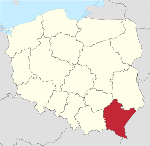
Subcarpathian Voivodeship
|
|||
| map | |||
|---|---|---|---|
  |
|||
| Coat of arms and logo | |||
 |
|
||
| Basic data | |||
| Capital : | Rzeszów | ||
| Voivode : | Ewa Leniart | ||
| Voivodeship Marshal : | Wladyslaw Ortyl | ||
| Biggest town: | Rzeszów | ||
| ISO 3166-2 : | PL-18 | ||
| Residents : | 2,129,138 (Dec. 31, 2017) | ||
| Population density : | 118 inhabitants per km² | ||
| License plate : | R. | ||
| geography | |||
| Area : | 17,844 km² | ||
| - of which country: | ? km² | ||
| - of which water: | ? km² | ||
| Expansion: | North-South: up to 180 km West-East: up to 169 km |
||
| The highest point: | 1346 m | ||
| Deepest point: | 138 m | ||
| Landscape structure | |||
| Forests: | 36.9% | ||
| Waters: | ? % | ||
| Agriculture: | 42.6% | ||
| Other: | ? % | ||
| Administrative division | |||
| Independent cities : | 4th | ||
| Counties : | 21st | ||
| - Municipalities : | 159 | ||
| - Cities : | 45 | ||
The Subcarpathian Voivodeship (Polish województwo podkarpackie [vɔjɛˈvut͡stfɔ pɔtkarˈpatskʲɛ] ) is one of 16 voivodeships of the Republic of Poland . It is located in the south-east of the country on the San River and borders Ukraine in the east and Slovakia in the south . The only big city is the capital Rzeszów .
In the south lie the outer Eastern Carpathians , which are part of the eponymous Subcarpathian Mountains .
coat of arms
Description : Split in red and blue with a silver paw cross on the split; in front a gold- armored and crowned silver griffin turned to the left and behind a red-tongued and thus armored golden lion with a crown .
Administrative division
The voivodeship is divided into 21 powiats ( counties ), with four cities being independent . They do not belong to the districts named after them.
One district cities
- Rzeszów (189,662)
- Przemyśl (61,808)
- Tarnobrzeg (47,387)
- Krosno (46,600)

Counties
- Bieszczady (21,891)
- Brzozów (65,938)
- Dębica (135,479)
- Jaroslaw (120,980)
- Jasło (114,156)
- Kolbuszowa (62,401)
- Krosno (112,481)
- Lesko (26,606)
- Leżajsk (69,641)
- Lubaczów (56,086)
- Łańcut (80,741)
- Mielec (136,666)
- Nisko (66,917)
- Przemyśl (74,440)
- Przeworsk (78,644)
- Ropczyce-Sędziszów (74.198)
- Rzeszów (169,165)
- Sanok (95,035)
- Stalowa Wola (107,138)
- Strzyżów (61,690)
- Tarnobrzeg (53,388)
(Residents on December 31, 2017)
geography
Biggest cities

| city | German name | Resident December 31, 2017 |
|---|---|---|
|
|
( Eng . in the Middle Ages :) Resche | 189,662 |
|
|
61.903 | |
|
|
Premissel, 1880 Przemyšl | 61,808 |
|
|
60,628 | |
|
|
47,387 | |
|
|
Krossen, 1880 Krosno | 46,600 |
|
|
Dembitza, 1880 Dembica | 46,063 |
|
|
Saanig, 1880 Sanok | 37,980 |
|
|
Jaroslau | 37,892 |
|
|
Jassel | 35,445 |
Ethnography of the Subcarpathian Region
Rivers
economy
The Subcarpathian Voivodeship is one of the poorest regions in the EU . In comparison with the EU GDP in terms of purchasing power standards , the voivodeship achieved an index of 35.8 in 2006 (EU-27 = 100). In 2015, the voivodeship improved to an index of 48 (EU-28 = 100). The unemployment rate in 2005 was 16.7%. By December 2009 it had dropped to 15.5 percent, which corresponds to 141,900 people. The unemployment rate in June 2010 was 14.7%.
With a value of 0.830, the Subcarpathian region ranks 13th among the 16 Voivodeships of Poland in the Human Development Index .
  |
 .jpg) |
  |
  |
  |
  |
  |
  |
Web links
- Subcarpathian Voivodeship (Polish, English)
- Castles and Palaces of Podkarpacie (Polish)
- Podkarpacie - Photo Gallery
Footnotes
- ↑ Premier Beata Szydło powołała nowych wojewodów. Retrieved February 15, 2017 (Polish).
- ^ Result of the 2011 census, Główny Urząd Statystyczny: Wyniki Narodowego Spisu Powszechnego Ludności i Mieszkań 2011. Warsaw, March 2012. Online ( Memento from January 16, 2013 in the Internet Archive ) (PDF)
- ↑ a b Główny Urząd Statystyczny: "LUDNOŚĆ - STAN I STRUKTURA W PRZEKROJU TERYTORIALNYM" , as of June 30, 2008 (PDF, select year)
- ^ Podkarpackie (Poland): Counties & Places - Population Statistics, Graphics and Map. Retrieved December 20, 2018 .
- ↑ Eurostat press release 23/2009: Regional GDP per inhabitant in the EU27 (PDF file; 360 kB).
- ↑ Eurostat. (PDF) Retrieved April 15, 2018 .
- ↑ Regional unemployment in the European Union, Bulgaria and Romania in 2005 ( Memento from September 27, 2007 in the Internet Archive )
- ↑ Central Statistics Office of Poland (CIS): Bezrobotni oraz stopa bezrobocia wg województw, grudzień 2009. ( Memento of April 2, 2015 in the Internet Archive ) February 3, 2010.
- ↑ Central Statistical Office of Poland (CIS), Rzeszów 2010.
- ^ Sub-national HDI - Area Database - Global Data Lab. Retrieved August 12, 2018 .

Warmia-Masuria | Greater Poland | Holy Cross | Subcarpathian | Lesser Poland | Kuyavia-Pomerania | Lebus | Łódź | Lublin | Mazovia | Lower Silesia | Opole | Podlaskie | Pomerania | Silesia | West Pomerania
Coordinates: 49 ° 57 ' N , 22 ° 10' E