Probsthain (Belgern-Schildau)
|
Probsthain
City of Belgern-Schildau
Coordinates: 51 ° 27 ′ 55 " N , 12 ° 53 ′ 49" E
|
|
|---|---|
| Height : | 110 m above sea level NN |
| Residents : | 305 (1990) |
| Incorporation : | January 1, 1994 |
| Incorporated into: | Schildau |
| Postal code : | 04889 |
| Area code : | 034221 |
|
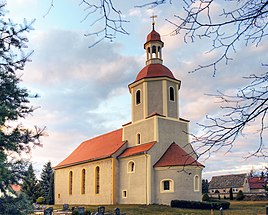
Church in Probsthain
|
|
Probsthain is a district of the town of Belgern-Schildau in the district of North Saxony in Saxony .
location
Probsthain is located northwest of the Gneisenau town of Schildau and of Belgern in an arable area. The corridor is on the northwestern edge of the Dahlener Heide . The main road 16 detected via local roads connecting the space moderate traffic.
history
The loosely laid out street village was first called Proftshayn in 1201 . The rural community has a corridor with 472 hectares of land. In 1818 there were 212 inhabitants in the village and in 1990 there were 305. The higher-level authority had its seat from 1314 in Torgau . In 1994 Probsthain was incorporated into Schildau and from January 1, 2013 into the city of Belgern-Schildau.
Web links
Commons : Probsthain - collection of images, videos and audio files
Individual evidence
- ^ Probsthain (Belgern-Schildau) in the Digital Historical Directory of Saxony
