
Raumünzach (river)
|
Raumünzach also used to be: Raumünz , in the upper reaches: Hundsbach |
||
 The Raumünzach in the sloping lower course (water withdrawal for hydroelectric use) |
||
| Data | ||
| Water code | EN : 2364 | |
| location |
Black Forest
|
|
| River system | Rhine | |
| Drain over | Murg → Rhine → North Sea | |
| Source Hundsbach (Schnakenloch) | Northeast slope of the Hornisgrinde 48 ° 37 ′ 9 ″ N , 8 ° 2 ′ 23 ″ E |
|
| Source height | approx. 1020 m above sea level NHN | |
| muzzle | at Raumünzach coordinates: 48 ° 38 ′ 22 ″ N , 8 ° 20 ′ 56 ″ E 48 ° 38 ′ 22 ″ N , 8 ° 20 ′ 56 ″ E |
|
| Mouth height | 389.5 m above sea level NHN in the Murg | |
| Height difference | approx. 630.5 m | |
| Bottom slope | approx. 47 ‰ | |
| length | 13.4 km | |
| Catchment area | 66.12 km² | |
| Discharge at the mouth of the A Eo : 66.12 km² |
MNQ MQ Mq MHQ HHQ |
450 l / s 2.93 m³ / s 44.3 l / (s km²) 58.91 m³ / s 316 m³ / s |
| Left tributaries | Greßbach, Schwarzenbach | |
| Right tributaries | Biberach | |
| Reservoirs flowed through | Erbersbronn collecting basin of the Rudolf-Fettweis factory | |
| Communities | Hundsbach | |
| Residents in the catchment area | about 400 | |
The Raumünzach is the largest tributary of the Murg in the northern Black Forest . The river drains an extensive forest area to the east of the main ridge around the Hornisgrinde and in the lower reaches becomes a sloping white water that has long been used to generate electricity.
geography
Course and valley landscape
The upper reaches of the Raumünzach, the Hundsbach, has two spring branches each about one kilometer long, of which the smaller northern one, which rises on the Unterstmatt , is recorded as Hundsbach in the topographic maps , whereas in the LUBW's online maps it is the larger southern one Source branch that rises from the back of the dog . The Hundsbachtal, like two neighboring, parallel side valleys, initially extends eastward. Almost all valleys in the Raumünzach catchment area are separated from one another by elongated, barely indented ridges that run east or northeast towards the Murg. These are the remnants of a gently sloping red sandstone ceiling that dominates the landscape and is underlain by granites that are almost impermeable to water . Therefore, numerous spring rivers emerge at the rock boundary, which flow in close succession to the main streams.
In the former logging town Ascheplatz the dog creek on the south-west direction of the valley of the left side creek swings Greßbach and then at settlement Hundsbach turn to the north-east direction of the valley of the creek side Biberach . Only from there the stately brook is called Raumünzach (formerly also Raumünz ). Between the two mouths and in the vicinity of the settlements, the stream flows through flat, wavy valley meadows in granite, otherwise through closed coniferous forest. About 2 kilometers above the mouth of the Biberach, both streams are diverted to the Schwarzenbachtalsperre through tunnels for hydropower use in the Rudolf-Fettweis plant .

The Raumünzach cuts gradually deeper into the granite, and the many short tributaries were able to create a moving relief towards the valley floor. After around 4 kilometers, water is withdrawn again from the Raumünzach. For this purpose, it is dammed into a small lake at the former lumberjack settlement in Erbersbronn. Below this, the gradient of the river increases significantly and remains almost like a torrent until it flows into the valley gorge of the also very steep middle Murg.
In this section with up to 2 meter high waste, the Schwarzenbach flows from the north (left) into a 4 meter high waterfall. Before the construction of the hydropower plant, the Raumünzach waterfall (named after the settlement at the confluence with the Murg) was a tourist destination as the highlight of the surrounding wild water landscape, which is unusual for a low mountain range . Especially when the Schwarzenbach was drained as a surge of water for the log drift, many onlookers often gathered. At present, however, this section of the river is mainly visited by white water canoes after intense rainfall or during the snowmelt, which, despite the drainage, will find one of the most demanding white water stretches in Germany.
Forbach granite is mined on the slopes of the brook gorge below the mouth of the Schwarzenbach . In this lowest section, the L 83 accompanies the valley floor; it connects Bühlertal with the Murgtal and the B 462, the Schwarzwald-Tälerstraße . In contrast, the less important L 80b connects the valley settlements above and leads through the Greßbachtal to the Black Forest High Road , which it reaches at the former Kurhaus Sand .
After a run of around 13.5 kilometers, the river in Raumünzach plunges into the Murg via an estuary cataract. It has an average water flow of almost 3 m³ / s and is therefore its largest tributary.
Tributaries
| Surname | Inflow of |
length | Catchment area |
Water supply |
Source area |
estuarine place |
Mouth height |
|---|---|---|---|---|---|---|---|
| Hundsb. (Quellb. Unterstmatt) | Left | 0.8 km | 0.7 km² | 35 l / s | Murkopf north slope | N back of dog (coord.) | 813.9 m above sea level NHN |
| Hundsb. (Quellb. Schnakenloch) | right | 1.3 km | 1.1 km² | 53 l / s | Hornisgrinde-NE-Hang ( Großes Mur ) | N back of dog (coord.) | 813.9 m above sea level NHN |
| Greßbach | Left | 4.6 km | 6.3 km² | 0.30 m³ / s | Hochkopf | Aschenplatz (coord.) | 680.6 m above sea level NHN |
| Biberach | right | 7.7 km | 9.8 km² | 0.43 m³ / s | Beaver cauldron on the Hornisgrinde | Biberach (coord.) | 623.5 m above sea level NHN |
| Schwarzenbach | Left | 11.2 km | 26.2 km² | 1.20 m³ / s | Mehliskopf | W Raumünzach (Coord.) | 457.4 m above sea level NHN |
- Raumünzach valley landscape

The valley landscape in the catchment area of the Raumünzach, characterized by coniferous forests

Where the Schwarzenbach flows into the Raumünzach (dehydration)
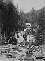
Where the Schwarzenbach flows into the Raumünzach (photo, before 1925)

The landscape of the Schwarzenbach tributary is similar to the Raumünzach.


Individual evidence
- ↑ a b c State Institute for the Environment Baden-Württemberg (LUBW) ( information ), height according to the contour line image on the background layer topographic map
- ↑ a b State Institute for the Environment Baden-Württemberg (LUBW) ( notes ), length according to the water network layer ( AWGN )
- ↑ a b c Geoportal Baden-Württemberg: LUBW Service Flowing Waters - Discharge parameters , accessed on May 11, 2020
- ^ Rudolf Metz: Mineralogical and regional hikes in the northern Black Forest, especially in its old mining districts. 2nd, completely revised edition, Schauenburg , Lahr 1977, ISBN 3-7946-0128-9