
Reussen Cross
| Reussen Cross | |||
|---|---|---|---|
| Pass height | 515 m above sea level NN | ||
| Odenwaldkreis , Hesse | |||
| Watershed | Pfeifersgrund ( Mümling / Main / Rhine ) |
Tunnelbach (Schöllenbach / Itter / Neckar / Rhine ) |
|
| Valley locations | Hetzbach in Beerfelden | Schöllenbach in Hesseneck | |
| expansion | State road | ||
| Mountains | Buntsandstein-Odenwald | ||
| Map (Hessen) | |||
|
|||
| Coordinates | 49 ° 34 '39 " N , 9 ° 1' 14" E | ||

The Reußenkreuz is a pass in the Odenwald in the Ober-Sensbach district of the city of Oberzent in the Odenwaldkreis in Hesse .
Geographical location
The Reußenkreuz is a 515 meter high wooded ridge in the red sandstone Odenwald east of Beerfelden . At the Reußenkreuz this ridge divides into three directions. To the north it leads to the Krähberg ( 555 m above sea level ) with the hunting lodge Krähberg , a few hundred meters away , to the southwest a kilometer-long ridge line leads to the Sensbacher Höhe ( 558 m above sea level ) and in the south-east lies the Breithaupt ( 522 m above sea level ), where the ridge divides further. The Reußenkreuz is located at a watershed between the Mümlingtal in the west, the Sensbach in the south and the Itter in the east, and it is on the watershed between the Main and Neckar . The valley slopes on both sides of the pass are steep and show a fragmented mountain relief.
The border of the Hetzbach district extends from the northwest to the Reußenkreuz. The district of Schöllenbach begins in the valley floor about one kilometer east of the Reußenkreuz . At Reußenkreuz there is a residential area with seven house numbers, including the Waldgasthof Reußenkreuz .
history
A forester's lodge was built on the Reußenkreuz around 30 years before the Krähberg hunting lodge was built. The restaurant Zum Auerhahn was later set up in it, later the Waldgasthof, whose name was changed to Reußenkreuz in 1935 .
There are different interpretations of the origin of the name. One says that the name originally meant travel cross (Reiser = forest, bush) and referred to a wayside shrine in the forest. According to another assumption, a St. Andrew's cross was erected here in honor of the family of the Tsar of all Reuss , who were related to the Grand Dukes of Hesse ( Marie von Hessen-Darmstadt and Alix von Hessen-Darmstadt ) . In the dispute over travel Cross or Reußenkreuz which laid Darmstadt Regional Council 1992, the official spelling Reußenkreuz firmly.

The wayside shrine north of the Reußenkreuz at the junction of the forest path to Bullau

The head of the image stick, St. Francis representing
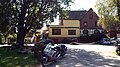
Forest restaurant Reußenkreuz


traffic
The 3100 meter long Krähberg tunnel of the Odenwaldbahn runs under the Reußenkreuz .
The state road 3108 , as a continuation of the federal road 460, forms a section of the Siegfriedstraße and follows the steep, winding slopes of the valley on both sides of the Reußenkreuz and thus offers the only road connection from Hesseneck to the rest of the Odenwaldkreis . The aim is to gain around 220 meters in altitude from both Hetzbach and Schöllenbach. This track was the venue since 1921 originally from Hesse Automobile Club organized Krähbergrennen .
The hiking car park Reußenkreuz , managed by the Geo-Naturpark Bergstrasse-Odenwald , invites you to hike on the forest paths of the extensive forest area.
Web links
- Reußenkreuz on the Internet
- Reisenkreuz, Odenwaldkreis. Historical local lexicon for Hesse (as of January 17, 2014). In: Landesgeschichtliches Informationssystem Hessen (LAGIS). Hessian State Office for Historical Cultural Studies (HLGL), accessed on July 6, 2014 .