
Rhone glacier
| Rhone glacier | ||
|---|---|---|
 Aerial view of the Rhone Glacier in September 2011 |
||
| location | Canton of Valais , Switzerland | |
| Mountains | Uri Alps | |
| Type | Valley glacier | |
| length | 7.8 km (2011) | |
| surface | 15.94 km² | |
| Exposure | south | |
| Altitude range | 3620 m above sea level M. - 2208 m above sea level M. (2005) | |
| Tilt | ⌀ 9 ° (16%) | |
| width | ⌀ 2 km | |
| Ice thickness | Max. 350 m | |
| Ice volume | 2.11 ± 0.38 km³ (2011) | |
| Coordinates | 672 316 / 161 776 | |
|
||
| drainage | Rhone | |

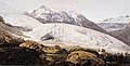
The Rhone Glacier (sometimes also called Rotten Glacier ) is a valley glacier in the headwaters of the Rhone in the extreme northeast of the canton of Valais in the central Alps of Switzerland . It is almost eight kilometers long, has an average width of about two kilometers and covers an area of about 16 km². The glacier was mainly in the 19th and early 20th century due to its then still far into the valley at Gletsch down-reaching tongue a great tourist attraction. It has been melting continuously since the middle of the 19th century. It may have almost completely disappeared by the year 2100.
location

The Rhone Glacier emerges on the relatively flat southwest slope of the Winterberg massif on the Dammastock at around 3,600 m above sea level. M. At first 2.5 kilometers, the ice rink is named Eggfirn and overcomes a height difference of about 600 m. At 3080 m , the glacier is connected to the Trift glacier to the north by the firn-covered Untere Triftlücke . The Rhone Glacier now flows south with slight turns and an average gradient of 16%, flanked by the Tieralplistock ( 3383 m ) and the Gärstenhörner ( 3189 m ) in the west and by the Galenstock ( 3586 m ) in the east. The glacier tongue is currently just over 2200 m above a steep rock slope. The Rhone rises here. Due to the steady retreat of the glacier, a small lake began to form behind the threshold of the steep slope in 2006/2007. This glacier tongue lake will increase significantly as the Rhone glacier melts further.
Expansion and retreat since the 19th century
During the high stage of the Little Ice Age in the 19th century and until the beginning of the 20th century, the Rhone Glacier reached over the steep slope below today's tongue down to the valley level of Gletsch at around 1800 m , at times until just before the hotels of Glacier. The maximum extent in 1856 can still be seen today on the basis of the smooth, bare rocks and the deposited moraine material. Since then, the glacier has been shrinking steadily and will possibly go back to the highest firn fields by the end of the 21st century.
Painting from 1770

1870

1900

1974

2005

2018

Map of the glacier extent
Course of the glacier front


Development
In the valley of Gletsch, about 1.5 m high pyramid-shaped columns with dates (from 1815) mark the glacier retreat in the 19th century. Because the Rhone Glacier is located on the Furkapassstrasse , a classic travel route through the Swiss Alps , it is the most easily accessible glacier in Switzerland. From the Hotel Belvédère on the pass road, which has been closed since 2015 , the glacier tongue can be reached via a footpath a few hundred meters long. Here you can visit an ice grotto. In order to maintain this, attempts are being made to delay the further retreat of the end of the glacier by covering it with white tarpaulins to protect it from solar radiation .

Interior view of the Rhone Glacier 2007

Ice, 2010

Close up

Blue ice in the ice cave 2010

Blue Ice 2010


Scientific investigations

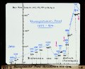
The Rhone Glacier is one of the best-researched glaciers ; the engineer Gosset began with the first geodetic measurements in 1874. Since then, an almost continuous series of observations has existed, both length and ice thickness changes have been systematically recorded. The flow speeds and directions in the various sections of the glacier were also examined. One result of the early glacier investigations is the book Surveying on the Rhone Glacier 1874–1915 by Paul-Louis Mercanton (1876–1963), published in 1916 , a standard work in glacier science. On average, the Rhone Glacier has retreated 8.5 m annually since 1874 and also lost around 25 cm of ice thickness every year.
As part of a project study by the Geographical Institute at Johannes Gutenberg University Mainz , a test wind trap was set up in August 2008 with the aim of examining the following thesis: In radiant weather conditions, so-called katabatic winds (cold winds) flow over the glacier ice down the valley. If a vestibule would succeed in damming up these cold downward winds, a cushion of cold air would have to be created to cool the surface of the glacier. The research team around the physical geographer Hans-Joachim Fuchs was able to record the project study as a success. The vestibule achieved the cooling effect. Over a period of six days, eleven measuring stations around the vestibule collected around 100,000 individual measured values. These confirm a maximum cooling effect of the vestibule of 3 ° C. A cold air cushion was created in the area of the vestibule.
The Ice Age Rhone Glacier


During the Ice Ages , the Rhone Glacier and its side glaciers each reached the largest ice mass of all Alpine glaciers. It filled the entire Valais Rhone Valley with an ice mass up to 2000 m thick and united with the glaciers that flowed from the Valais side valleys, from the Mont Blanc massif and from the Freiburg and Bernese Alps. In the area of Lake Geneva it divided into two arms, one of which extended further down the Rhone valley to the area east of Lyon . The other arm extended over the heights of the Jorat to the northeast, covering the entire western central plateau with ice and joining the Aare glacier in the Bern region . During the high stages of the Riss and Würme Ice Age , the Jura chain in the area of Mont Tendre, which is closest to the Swiss Plateau , was partly covered by the ice of the Rhone Glacier. During the Würme Ice Age, the Rhone Glacier advanced as far as the area of Wangen an der Aare between Solothurn and Langenthal , as evidenced by the remains of former moraines and early buildings made of alpine rock such as the church of Oberdorf and the castle tower of Halt . Boulders consisting of granite or gneiss from the Valais Alps are common in the western Swiss Plateau. They could only be transported to their locations through a glacier, which is why they provided a main argument for the foundation of the Ice Age theory (among others by Louis Agassiz ).
literature
- Armin Baltzer: Contributions to the knowledge of the diluvial Rhone glacier. In: Eclogae geologicae Helvetiae, 6 (1899/1900), pp. 378-391
- Emilie Boré: La naissance de l'iconographie du glacier au siècle des Lumières. Le cas du Glacier du Rhône . In: Annales valaisannes , 2013, pp. 9–47
- Fritz Müller ( inter alia): Combined ice, water and energy balances of a glacierized basin of the Swiss Alps. The Rhone Glacier project . In: Geographica Helvetica, 35 (1980), pp. 57-69
- Fritz Müller (Ed.): The Rhone Glacier and its surroundings. A contribution to glacier and climate research by the Geographical Institute of ETH Zurich , Zurich 1980
Web links
- Rhone glacier on Glaciers online
- Creation of new lakes on the Rhone Glacier
- Rhone glacier
- Information and photos about the Rhone glacier as well as interesting facts about glaciers in general
- Simulation by ETH Zurich on the retreat of the Rhone glacier
- Stephanie Summermatter: Rhone Glacier. In: Historical Lexicon of Switzerland .
- Rhone glacier on the ETHorama platform
- Interactive before and after comparison pictures of the Rhone Glacier
- Ice grotto with a glacier trail
Individual evidence
- ^ Research institute for hydraulic engineering, hydrology and glaciology (VAW) of the ETH Zurich (ed.): Rhonegletscher. In: Swiss Glacier Measurement Network. ( ethz.ch , also as PDF , accessed on February 19, 2014).
- ↑ a b Daniel Farinotti, Matthias Huss, Andreas Bauder, Martin Funk: An estimate of the glacier ice volume in the Swiss Alps . In: Global and Planetary Change , 68: 225–231, 2009 ( online ; PDF; 756 kB)
- ^ WGMS: Fluctuations of Glaciers Database. World Glacier Monitoring Service, Zurich 2013 ( DOI: 10.5904 / wgms-fog-2013-11 ), accessed on December 11, 2013
- ^ Research institute for hydraulic engineering, hydrology and glaciology (VAW) of the ETH Zurich : Aletsch Glacier. In: Glacier Natural Hazards. ( ethz.ch ( page no longer available ), also as a PDF ( page no longer available ), accessed on February 6, 2013).
- ↑ a b oberwaldgletsch.ch: Furkapass sights ( Memento of the original from March 5, 2013 in the Internet Archive ) Info: The archive link was inserted automatically and has not yet been checked. Please check the original and archive link according to the instructions and then remove this notice.
- ↑ TagesAnzeiger: The Rhone Glacier will be gone in 90 years
- ↑ WWF Switzerland : Federal Council's climate policy costs us the Rhone Glacier In: wwf.ch, June 15, 2018, accessed on June 23, 2018
- ↑ Martin W. Carlen: The Rhone Glacier and its ice grotto . Belvedere at the Furka Pass, 1994
- ↑ Michèle Schell: With tarpaulins against the ice melt - the Rhone glacier is melting at record speed. In: nzz.ch. Neue Zürcher Zeitung , June 20, 2018, accessed on January 29, 2019 .
- ^ Eduard Hagenbach-Bischoff: About the physical-topographical recording of the Rhone glacier by engineer Gosset in the years 1874-1876 . In: Negotiations of the Swiss Natural Research Society , 59, 1876, pp. 158–166
- ↑ Project study 2008: Effects of climate change on the Swiss Alpine glaciers - wind trap on the Rhône glacier ( Memento of the original from July 12, 2011 in the Internet Archive ) Info: The archive link was inserted automatically and has not yet been checked. Please check the original and archive link according to the instructions and then remove this notice.
- ^ Walter Moser: Erratic boulders in the canton of Solothurn, witnesses to two ice ages . In: Jahrbuch für Solothurnische Geschichte, 67. 1994, pp. 137–151