
Screech neck
|
Screech neck
City of Solingen
Coordinates: 51 ° 9 ′ 16 ″ N , 7 ° 1 ′ 3 ″ E
|
||
|---|---|---|
| Height : | about 120 m | |
| Postal code : | 42699 | |
| Area code : | 0212 | |
Location of Riefnacken in Solingen |
||
 Screech neck
|
||

Riefnacken is a court in the Bergisch city of Solingen .
geography
Riefnacken is located in the Aufderhöhe district between Höhscheider and Uferstraße. Behind a small valley cut in the north of Riefnacken lies the Hülsen farm directly on the riverside road. Further north, the terrain slopes down into the Viehbach valley . To the east of Riefnacken is Heipertz , behind it the An den Eichen industrial park and the Friedenstrasse. To the west are Aufderbech and Neuenufer . In the north-east is the junction of Viehbachtalstraße at the Black Piles, south of it is the Junkernhäuschen residential area .
etymology
The origin of the place name Riefnacken has not been conclusively clarified. Perhaps the word contains the suffix -nacken , which, similar to the Höhscheider Hofschaft Nacken, could be a formal word for elevations.
history
The Riefnacken court can be traced back to the 16th century. In the year 1715 Riefnacken is recorded in the map Topographia Ducatus Montani , Blatt Amt Solingen , by Erich Philipp Ploennies with a farm and named as Rifen . This is obviously an abbreviation, according to Brangs. The court belonged to the Honschaft Barl within the office of Solingen. The topographical survey of the Rhineland from 1824 lists the place as Reifnaken and the Prussian first survey from 1844 unlabeled. In the topographic map of the Düsseldorf administrative district from 1871, the place is also recorded without a name.
After the establishment of the Mairien and later mayor's offices at the beginning of the 19th century, Riefnacken belonged to the Merscheid mayor, which was elevated to a town in 1856 and renamed Ohligs in 1891.
In 1815/16 there were 35 people living in the hamlet called Riefnacken , in 1830 41 people . There he was in hallway VIII. Wieveldick. The place, which was categorized as a court town according to the statistics and topography of the administrative district of Düsseldorf , had six residential buildings and eight agricultural buildings at that time. At that time 56 inhabitants lived in the place, two of them Catholic and 54 Evangelical denominations. The municipality and estate district statistics of the Rhine Province list the place in 1871 with nine houses and 51 inhabitants. In the municipality lexicon for the Rhineland province of 1888, ten houses with 63 inhabitants are given for Riefnacken. In 1895 the district had eleven houses with 79 inhabitants.
With the town union of Groß-Solingen in 1929, the Riefnacken court became a district of Solingen. Since 1986 the buildings Riefnacken 25, 27 and 37 of the historical half-timbered houses in the village are under monument protection .

Road sign
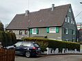
Half-timbered house in Riefnacken

Half-timbered houses in Riefnacken

Riefnacken Monument 37


Web links
- Marina Alice Mutz: Riefnacken on zeitspurensuche.de
swell
- ↑ a b Hans Brangs: Explanations and explanations for the corridor, place, yard and street names in the city of Solingen . Solingen 1936
- ^ City of Solingen: Street and place names in our city of Solingen , self-published, Solingen 1972
- ^ Topographic map of the Düsseldorf administrative district . Designed and executed according to the cadastral recordings and the same underlying and other trigonometric work by the Royal Government Secretary W. Werner. Edited by the royal government secretary FW Grube. 4th rev. Edition / published by A. Bagel in Wesel, 1859 / Ddf., Dec. 17, 1870. J. Emmerich, Landbaumeister. - Corrected after the ministerial amendments. Ddf. d. Sept. 1, 1871. Bruns.
- ↑ a b Johann Georg von Viebahn : Statistics and Topography of the Administrative District of Düsseldorf , 1836
- ↑ Friedrich von Restorff : Topographical-statistical description of the Royal Prussian Rhine Province , Nicolai, Berlin and Stettin 1830
- ↑ Royal Statistical Bureau Prussia (ed.): The communities and manor districts of the Prussian state and their population . The Rhine Province, No. XI . Berlin 1874.
- ↑ Königliches Statistisches Bureau (Prussia) (Ed.): Community encyclopedia for the Rhineland Province, based on the materials of the census of December 1, 1885 and other official sources, (Community encyclopedia for the Kingdom of Prussia, Volume XII), Berlin 1888.
- ↑ Königliches Statistisches Bureau (Prussia) (Ed.): Community encyclopedia for the Rhineland Province, based on the materials of the census of December 1, 1895 and other official sources, (Community encyclopedia for the Kingdom of Prussia, Volume XII), Berlin 1897.
- ↑ Solingen Monument List ( Memento of the original from December 18, 2015 in the Internet Archive ) Info: The archive link was inserted automatically and has not yet been checked. Please check the original and archive link according to the instructions and then remove this notice. . City of Solingen, July 1, 2015, accessed on July 3, 2016 (PDF, size: 129 kB).
Altenufer | Anchor | Auenberg | Aufderbech | Aufderhöhe | Aufm Scheidt | Bakershof | Barl | Bauermannsheide | Bavert | Bech | Gantry stairs | Börkhaus | Brabant | Broßhaus | Broßhauser Mill | Chapel | Dahl | Dahler Hammer | Diepenbruch | Deusberg | Dunkelnberg | Engelsberg | Engelsberger Hof | Fürk | Fürker Irlen | Garzenhaus | Götsche | Abomination | Hasselsheide | House | Heather | Heiligenstock | Heipertz | Honingsheide | Hübben | Sleeves | Cottage house | Valley of tears | Junker's house | Itter | Caspersbroich | Kalstert | Keusenhof | Klein-Heipertz | Little Holland | Kleinohligs | Kottendorf | Kovelenberg | Kuckesberg | Kullen | Limminghofen | Linden | Hole | Löhdorf | Maubes | Maubeshaus | Merscheid | Merscheider Busch | Monhof | Mondorf | Nassenweg | Neuenhaus | Neuenufer | Neu-Löhdorf | Obenmankhaus | Ohligs | Breakdown bottle | Pfaffenbusch | Piepers | Pohligshof | Poschheide | Poschheider Mill | Potzhof | Rennpatt | Scarf neck | Rosenkamp | Scharrenberg | Scharrenbergerheide | Scharrenberger Mill | Scouring | Schleifersberg | Lard pit | Tailors | Schorberg | Black house | Siebels | Siebelskamp | Streets | Soup heather | Deep Thick | Defiant | Downstairs house | Laugh | Waardt | Wahnenkamp | Weyer | Wiefeldick | Wilzhaus | To the Scheidt