
Neck (Solingen)
|
neck
City of Solingen
Coordinates: 51 ° 9 ′ 47 " N , 7 ° 2 ′ 53" E
|
||
|---|---|---|
| Height : | about 130 m | |
| Postal code : | 42655 | |
| Area code : | 0212 | |
Location of Nacken in Solingen |
||
 neck
|
||

Nacken is a court in the border area between the two districts of Solingen, Mitte and Höhscheid .
geography
Nacken is located on the banks of the Nacker Bach , named after the place , which rises in the II. Heidberg , runs in a south-westerly direction over Nacken and Brücke and finally flows into the Wupper at Haasenmühle . The Hofschaft Nacken is located in the Nacker Bachtal, which extends between a mountain range in the north and south. The Mangenberger Straße runs on the northern ridge, there are the villages of Hoffnung and Hübben , and the Wuppertal-Oberbarmen-Solingen railway line runs on a dam in the north of Nacken . The Hossenhauser Strasse runs along the ridge to the south, where the Hossenhaus residential area is located . East of Nacken are Geilenberg , Jakobshäuschen and the Kotter Hammer . To the west are Schmalzgrube , Schaafenmühle and Obenkatternberg .
etymology
According to Dittmaier , neck is a formal word for elevations in the ground . The word also occurs in Vossnacken near Velbert - Langenberg and Scharpenacken near Wuppertal - Ronsdorf .
history
The Nacken court can be traced back to the year 1488, when it was first mentioned as zom Nacken in the tithe register of the Altenberg monastery . In 1639 the place was mentioned in the Reformed baptismal register forest as Auf dem Nacken .
In the year 1715 Nacken is recorded in the map Topographia Ducatus Montani , Blatt Amt Solingen , by Erich Philipp Ploennies with a farm and as a. Named neck . He belonged to the Katternberg Honschaft within the Solingen office. The topographical survey of the Rhineland from 1824 shows the place as the neck and the Prussian first survey of 1844 again as the neck . In the topographic map of the Düsseldorf administrative district from 1871, the place is also shown as the neck .
After the establishment of the Mairien and later mayor's offices at the beginning of the 19th century, Nacken belonged to the Höhscheid mayor's office . 1815/16 lived 49 in 1830, 59 people in a hamlet called neck . In 1832 the place was still part of the Katternberg Honschaft within the mayor's office of Höhscheid. The place, which was categorized as a court town according to the statistics and topography of the Düsseldorf administrative district , had ten residential buildings and ten agricultural buildings at that time. At that time, 68 residents lived in the village, 15 of them Catholic and 53 Protestant. The municipality and estate district statistics of the Rhine Province list the place in 1871 with eight houses and 80 inhabitants. In the municipality lexicon for the Rhineland province of 1888, 14 houses with 84 inhabitants are given for Nacken . In 1895 the district had 12 houses with 75 inhabitants and belonged to the Catholic parish of Solingen, in 1905 eleven houses and 89 inhabitants are given.
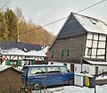
With the town union of Groß-Solingen in 1929, the Nacken court became a district of Solingen. Since the years 1984 to 1986, of the historic half-timbered houses in Nacken, the buildings Nacken 1, 1a, 3, 5, 9 and the building Nacker Weg 47 have been listed .

Neck from the east

Half-timbered houses in the neck

Half-timbered building Nacken 1, 1a
Half-timbered houses Nacken 3 and 5

Half-timbered house Nacker Weg 47


Web links
- Marina Alice Mutz: Hofschaft Nacken on zeitspurensuche.de
swell
- ^ Heinrich Dittmaier : settlement names and settlement history of the Bergisches Land . In: Journal of the Bergisches Geschichtsverein . tape 74 , parallel edition as a publication by the Institute for Historical Regional Studies of the Rhineland at the University of Bonn. Schmidt, Neustadt ad Aisch 1956.
- ↑ Hans Brangs: Explanations and explanations for the corridor, place, yard and street names in the city of Solingen . Solingen 1936
- ↑ Marina Alice Mutz: Neck. In: Time Track Search. Retrieved January 1, 2017 .
- ^ Topographic map of the Düsseldorf administrative district . Designed and executed according to the cadastral recordings and the same underlying and other trigonometric work by the Royal Government Secretary W. Werner. Edited by the royal government secretary FW Grube. 4th rev. Edition / published by A. Bagel in Wesel, 1859 / Ddf., Dec. 17, 1870. J. Emmerich, Landbaumeister. - Corrected after the ministerial amendments. Ddf. d. Sept. 1, 1871. Bruns.
- ↑ a b c Johann Georg von Viebahn : Statistics and Topography of the Düsseldorf Government District , 1836
- ↑ Friedrich von Restorff : Topographical-statistical description of the Royal Prussian Rhine Province , Nicolai, Berlin and Stettin 1830
- ↑ Royal Statistical Bureau Prussia (ed.): The communities and manor districts of the Prussian state and their population . The Rhine Province, No. XI . Berlin 1874.
- ↑ Königliches Statistisches Bureau (Prussia) (Ed.): Community encyclopedia for the Rhineland Province, based on the materials of the census of December 1, 1885 and other official sources, (Community encyclopedia for the Kingdom of Prussia, Volume XII), Berlin 1888.
- ↑ Königliches Statistisches Bureau (Prussia) (Ed.): Community encyclopedia for the Rhineland Province, based on the materials of the census of December 1, 1895 and other official sources, (Community encyclopedia for the Kingdom of Prussia, Volume XII), Berlin 1897.
- ↑ Royal Statistical Bureau (Prussia) (Ed.): Community encyclopedia for the Rhineland Province, based on the materials of the census of December 1, 1905 and other official sources, (Community encyclopedia for the Kingdom of Prussia, Volume XII), Berlin 1909
- ↑ Solingen Monument List ( Memento of the original from December 18, 2015 in the Internet Archive ) Info: The archive link was inserted automatically and has not yet been checked. Please check the original and archive link according to the instructions and then remove this notice. . City of Solingen, July 1, 2015, accessed on January 1, 2017 (PDF, size: 129 kB).
Aufderhöhe | Farmer's Bull | Bell house | Bergerstrasse | Bernskotten | Bedlenberg | Birkendahl | Bodlenberg | Böckersberg | Fallow | Fire | Breitestrasse | Bridge | Burbach | Caspersfeld | Crown mill | Dent | Eichenberg | Eickenberg | Unity | Erf | Erferstrasse | Ernenkotten | Evertsaue | Feldstrasse | Friedrichsaue | Friedrichshöhe | Friedrichstal | Geilenberg | Gillich | Gillicher Dahl | Gutter | Abomination | Grünenthal | Shark Siepen | Haasenmühle | Hackhausen Castle | Hackhauser Hof | Heather | Henkelskotten | Hensberg | Hingenberg | Hintenmeiswinkel | Hofchen | Higher heather | Höhmannsberg | Höhscheider Hof | Höhscheiderplatz | Hope | Holzhof | Holzkamp | Horn | Hossenhaus | Hut | Irler Hof | Jakobshäuschen | Johänntgesbruch | Valley of tears | Josefstal | Chapel of St. Reinoldi | Kesselsweiler | Cherry heather | Kohlsberg | Kotten | Kotterhammer | Kotterheidberg | Kottermühle | Krüdersheide | Kulle | Pool | Landwehr | Linden tree | Lindenhof | Lindenstrasse | Löhdorf | Melcherskotten | Michelshäuschen | Mittelhöhscheid | Mittelfürkelt | Mittelkatternberg | Central Pilgrimage House | Neck | Nacker Küllenberg | Nesterkotten | Neuenhaus | Neuenhauserkotten | Neuenhof | Neuenkamp | Nöhrenhaus | Nöhrenkotten | Walnut | Above forkelt | Obenhöhscheid | Obenkatternberg | Upper Pilgrim House | Male | Obenweeg | Obenwiddert | Oil mill | Parkstrasse | Pilghauser Kotten | Platzhof | Platzhofermühle | Pereskotten | Rölscheid | Röscheid | Rupelrath | Schaafenkotten | Schaafenmühle | Soundbreak mill | Schirpenberg | Schirpenbruch | Turnpike | Siepen | Steigerhäuschen | Steinendorf | Streets | Strupsmühle | Room | Potions | Downfucked | Unterhöhscheid | Untenkatternberg | Down Pilgrim House | Males | Down Aries | Vockert | Vormeiswinkel | Wax sack | Weyerberg | Weegerberg | Weegerstraße | Weinsberg | Seesaw | Wipperaue | Seesaw gangs | Desert farm | Desert road | Wusthofskotten