
Geilenberg (Solingen)
|
Geilenberg
City of Solingen
Coordinates: 51 ° 9 ′ 52 ″ N , 7 ° 3 ′ 8 ″ E
|
||
|---|---|---|
| Height : | about 170 m | |
| Postal code : | 42655 | |
| Area code : | 0212 | |
Location of Geilenberg in Solingen |
||
 Geilenberg
|
||

Geilenberg is a court in the Bergisch city of Solingen .
geography
Geilenberg is located on a northern slope of the Nacker Bachtal between the two Solingen districts of Mitte and Höhscheid . The railway line Wuppertal-Oberbarmen-Solingen runs on a small dam in the north , which is also spanned by a bridge near Geilenberg. Mangenberger Straße runs on the ridge north of Geilenberg. Further north, on the southern slope of the Viehbach Valley , are Hope and Waardt . In the east of Geilenberg lies the Kotten estate , in the southeast is the Kotter Hammer . Hossenhauser Straße runs along the ridge to the south, where the Hossenhaus residential area is located . Nacken is located southwest of Geilenberg, on the banks of the Nacker Bach .
etymology
The word Geilenberg is derived from the old German personal name Geido , who was perhaps once the founder or simply an owner of the farm.
history
The Hofschaft Geilenberg can be traced back to 1488 when it as zom Geydenbergh first documented in Zehntregister the Monastery Altenberg is mentioned. The farm is also mentioned as Geyndenbergh .
In 1715 , Erich Philipp Ploennies recorded Geilenberg in the map Topographia Ducatus Montani , Blatt Amt Solingen , and named it Geilenberg . He belonged to the Katternberg Honschaft within the Solingen office. The topographical survey of the Rhineland from 1824 lists the place as Geilenberg and the Prussian first survey from 1844 again as Geilenberg . In the topographic map of the Düsseldorf administrative district from 1871, the place is also recorded as Geilenberg .
After the Mairien and later mayor's offices were founded at the beginning of the 19th century, Geilenberg belonged to the Höhscheid mayor's office , there in corridor II ( Pilghausen ). In 1815/16 48 people lived in Geilenberg, known as the hamlet , in 1830 58 people . In 1832 the place was still part of the Katternberg Honschaft within the mayor's office of Höhscheid. The place, which was categorized as a court town according to the statistics and topography of the Düsseldorf administrative district , had ten residential buildings and ten agricultural buildings at that time. At that time 65 people lived in the place, including one Catholic and 64 Protestant denomination. The municipality and estate district statistics of the Rhine Province list the place in 1871 with twelve houses and 73 inhabitants. In the municipality lexicon for the province of Rhineland from 1888, 13 houses with 105 inhabitants are given for Geilenberg. In 1895 the district had 13 houses with 109 inhabitants and belonged to the Catholic parish of Solingen, in 1905 twelve houses and 106 inhabitants are given.
In the mid-1860s, the northern part of the Hofschaft fell victim to the construction of the railway line between Solingen and Ohligs , which was completed in 1867. It was not until many years later that a bridge was built, which tied the still existing southern part of Geilenberg to Geilenberger Weg and Mangenberger Straße without crossing . With the town union of Groß-Solingen in 1929, the Geilenberg court became a district of Solingen. Since the year 1984 which is in Geilenberg verschieferte timbered house Geilenberg 9 under monument protection .

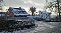
Court houses in Geilenberg

Access to the farm through the Nacker Bachtal
Bridge over the railway line at Geilenberg

Slated half-timbered house in Geilenberg


Web links
swell
- ↑ a b Hans Brangs: Explanations and explanations for the corridor, place, yard and street names in the city of Solingen . Solingen 1936
- ↑ a b City of Solingen: Street and place names in our city of Solingen , self-published, Solingen 1972
- ^ Topographic map of the Düsseldorf administrative district . Designed and executed according to the cadastral recordings and the same underlying and other trigonometric work by the Royal Government Secretary W. Werner. Edited by the royal government secretary FW Grube. 4th rev. Edition / published by A. Bagel in Wesel, 1859 / Ddf., Dec. 17, 1870. J. Emmerich, Landbaumeister. - Corrected after the ministerial amendments. Ddf. d. Sept. 1, 1871. Bruns.
- ↑ a b c Johann Georg von Viebahn : Statistics and Topography of the Düsseldorf Government District , 1836
- ↑ Friedrich von Restorff : Topographical-statistical description of the Royal Prussian Rhine Province , Nicolai, Berlin and Stettin 1830
- ↑ Royal Statistical Bureau Prussia (ed.): The communities and manor districts of the Prussian state and their population . The Rhine Province, No. XI . Berlin 1874.
- ↑ Königliches Statistisches Bureau (Prussia) (Ed.): Community encyclopedia for the Rhineland Province, based on the materials of the census of December 1, 1885 and other official sources, (Community encyclopedia for the Kingdom of Prussia, Volume XII), Berlin 1888.
- ↑ Königliches Statistisches Bureau (Prussia) (Ed.): Community encyclopedia for the Rhineland Province, based on the materials of the census of December 1, 1895 and other official sources, (Community encyclopedia for the Kingdom of Prussia, Volume XII), Berlin 1897.
- ↑ Königliches Statistisches Bureau (Prussia) (Ed.): Community encyclopedia for the Rhineland Province, based on the materials of the census of December 1, 1905 and other official sources, (Community encyclopedia for the Kingdom of Prussia, Volume XII), Berlin 1909.
- ↑ Solingen Monument List ( Memento of the original from December 18, 2015 in the Internet Archive ) Info: The archive link was inserted automatically and has not yet been checked. Please check the original and archive link according to the instructions and then remove this notice. . City of Solingen, July 1, 2015, accessed on January 1, 2017 (PDF, size: 129 kB).
Aufderhöhe | Farmer's Bull | Bell house | Bergerstrasse | Bernskotten | Bedlenberg | Birkendahl | Bodlenberg | Böckersberg | Fallow | Fire | Breitestrasse | Bridge | Burbach | Caspersfeld | Crown mill | Dent | Eichenberg | Eickenberg | Unity | Erf | Erferstrasse | Ernenkotten | Evertsaue | Feldstrasse | Friedrichsaue | Friedrichshöhe | Friedrichstal | Geilenberg | Gillich | Gillicher Dahl | Gutter | Abomination | Grünenthal | Shark Siepen | Haasenmühle | Hackhausen Castle | Hackhauser Hof | Heather | Henkelskotten | Hensberg | Hingenberg | Hintenmeiswinkel | Hofchen | Higher heather | Höhmannsberg | Höhscheider Hof | Höhscheiderplatz | Hope | Holzhof | Holzkamp | Horn | Hossenhaus | Hut | Irler Hof | Jakobshäuschen | Johänntgesbruch | Valley of tears | Josefstal | Chapel of St. Reinoldi | Kesselsweiler | Cherry heather | Kohlsberg | Kotten | Kotterhammer | Kotterheidberg | Kottermühle | Krüdersheide | Kulle | Pool | Landwehr | Linden tree | Lindenhof | Lindenstrasse | Löhdorf | Melcherskotten | Michelshäuschen | Mittelhöhscheid | Mittelfürkelt | Mittelkatternberg | Central Pilgrimage House | Neck | Nacker Küllenberg | Nesterkotten | Neuenhaus | Neuenhauserkotten | Neuenhof | Neuenkamp | Nöhrenhaus | Nöhrenkotten | Walnut | Above forkelt | Obenhöhscheid | Obenkatternberg | Upper Pilgrim House | Male | Obenweeg | Obenwiddert | Oil mill | Parkstrasse | Pilghauser Kotten | Platzhof | Platzhofermühle | Pereskotten | Rölscheid | Röscheid | Rupelrath | Schaafenkotten | Schaafenmühle | Soundbreak mill | Schirpenberg | Schirpenbruch | Turnpike | Siepen | Steigerhäuschen | Steinendorf | Streets | Strupsmühle | Room | Potions | Downfucked | Unterhöhscheid | Untenkatternberg | Down Pilgrim House | Males | Down Aries | Vockert | Vormeiswinkel | Wax sack | Weyerberg | Weegerberg | Weegerstraße | Weinsberg | Seesaw | Wipperaue | Seesaw gangs | Desert farm | Desert road | Wusthofskotten