
Dahl (Solingen)
|
Dahl
City of Solingen
Coordinates: 51 ° 10 ′ 4 ″ N , 7 ° 2 ′ 16 ″ E
|
||
|---|---|---|
| Height : | about 150 m | |
| Postal code : | 42699 | |
| Area code : | 0212 | |
Location of Dahl in Solingen |
||
 Dahl
|
||

The Dahl estate is located in the Merscheid district of Solingen . Due to its historical importance as a place where court was held in the 17th and 18th centuries and where many judges were based, it is one of the most important courts in its area. The Richterhaus in Dahl , built in 1558, is one of the oldest, almost completely preserved buildings in Solingen.
location
Dahl is located in a wooded area on the banks of the Viehbach , not far from the Viehbach Valley Road, named after the course of the river that runs parallel to it . The Hofschaft can be reached via a cul-de-sac, the Kyllmannweg , to Landesstraße 141 ( Merscheider Straße ). The Kyllmannweg leads steeply down into the Viehbachtal. The development of the courtyard begins on the bank of the river.
history
Several locally known judges had their residence in Dahl, and some of the negotiations were held in the court. There was also a prison in the basement of one of the buildings. This earned the court an important reputation. The judges included the Kyllmann family, from which many judges of the Solingen office emerged, and Rütger Vischer, who lived in the judges 'house during the Thirty Years' War .
In 1715 Erich Philipp Ploennies recorded the place in the map Topographia Ducatus Montani , Blatt Amt Solingen , with a farm and named it Dahl . The place belonged to the Honschaft Barl within the office of Solingen. The topographical survey of the Rhineland from 1824 lists the place as im Dahl and the Prussian first survey of 1844 as Dahl . In the topographic map of the Düsseldorf administrative district from 1871, the place is also recorded as Dahl .
After the establishment of the Mairien and later mayor's offices at the beginning of the 19th century, Dahl belonged to the Merscheid mayor , which was elevated to a town in 1856 and renamed Ohligs in 1891.
In 1815/16 47 people lived in Dahl, known as the hamlet with iron hammer , in 1830 67 people . In 1832 the place was still part of the Honschaft Barl within the mayor's office Merscheid , there it was in the corridor V. Merscheid . The place, which was categorized as a Hofstadt according to the statistics and topography of the Düsseldorf administrative district , had 13 residential buildings and ten agricultural buildings at that time. At that time, 53 people lived in the village, two of them Catholic and 51 Protestant. The municipality and estate district statistics of the Rhine Province list the place in 1871 with 14 houses and 81 inhabitants. In the municipality lexicon for the Rhineland province from 1888, 17 houses with 111 inhabitants are given for Dahl . In 1895 the district had 19 houses with 108 residents.
When the road was built , the court barely escaped destruction. It was only because of the resistance of the local population that the road was planned with a different route around the historical place. The cattle Bachtalstraße was finally realized in the 1980s, the dilapidated Richterhaus exemplary rehabilitated.
There are still numerous centuries-old half-timbered houses in the courtyard, some of them with typical Bergisch slate cladding . Among them are the imposing half-timbered building ( Judges House ), built in 1558, the so-called Bench House , built in 1747, and in 1793 built Peter-Knecht-house , which in 1993 by the Hofschaft silts translocated was. All three buildings mentioned are listed. In addition, the entire Dahl court with its various half-timbered houses is protected in the monument register of the city of Solingen as a so-called monument area, which means that structural measures on all buildings in this area are only permitted if they do not significantly change the appearance of the town. It should definitely be preserved as an example for the many similar courts.

Half-timbered houses in Dahl

Judges House
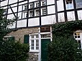
Richterhaus (facade detail)

Schöffenhaus

Peter Knecht House


Web links
literature
- Manfred Kohl: Solingen-Ohlig leaps in time. Suttonverlag, Erfurt 2007, ISBN 978-3-86680-229-2
swell
- ↑ Brief overview of the history of the court . Internet source with secondary sources. at: zeitspurensuche.de , accessed on November 23, 2014
- ^ Topographic map of the Düsseldorf administrative district . Designed and executed according to the cadastral recordings and the same underlying and other trigonometric work by the Royal Government Secretary W. Werner. Edited by the royal government secretary FW Grube. 4th rev. Edition / published by A. Bagel in Wesel, 1859 / Ddf., Dec. 17, 1870. J. Emmerich, Landbaumeister. - Corrected after the ministerial amendments. Ddf. d. Sept. 1, 1871. Bruns.
- ↑ a b c Johann Georg von Viebahn : Statistics and Topography of the Düsseldorf Government District , 1836
- ↑ Friedrich von Restorff : Topographical-statistical description of the Royal Prussian Rhine Province , Nicolai, Berlin and Stettin 1830
- ↑ Royal Statistical Bureau Prussia (ed.): The communities and manor districts of the Prussian state and their population . The Rhine Province, No. XI . Berlin 1874.
- ↑ Königliches Statistisches Bureau (Prussia) (Ed.): Community encyclopedia for the Rhineland Province, based on the materials of the census of December 1, 1885 and other official sources, (Community encyclopedia for the Kingdom of Prussia, Volume XII), Berlin 1888.
- ↑ Königliches Statistisches Bureau (Prussia) (Ed.): Community encyclopedia for the Rhineland Province, based on the materials of the census of December 1, 1895 and other official sources, (Community encyclopedia for the Kingdom of Prussia, Volume XII), Berlin 1897.
Altenufer | Anchor | Auenberg | Aufderbech | Aufderhöhe | Aufm Scheidt | Bakershof | Barl | Bauermannsheide | Bavert | Bech | Gantry stairs | Börkhaus | Brabant | Broßhaus | Broßhauser Mill | Chapel | Dahl | Dahler Hammer | Diepenbruch | Deusberg | Dunkelnberg | Engelsberg | Engelsberger Hof | Fürk | Fürker Irlen | Garzenhaus | Götsche | Abomination | Hasselsheide | House | Heather | Heiligenstock | Heipertz | Honingsheide | Hübben | Sleeves | Cottage house | Valley of tears | Junker's house | Itter | Caspersbroich | Kalstert | Keusenhof | Klein-Heipertz | Little Holland | Kleinohligs | Kottendorf | Kovelenberg | Kuckesberg | Kullen | Limminghofen | Linden | Hole | Löhdorf | Maubes | Maubeshaus | Merscheid | Merscheider Busch | Monhof | Mondorf | Nassenweg | Neuenhaus | Neuenufer | Neu-Löhdorf | Obenmankhaus | Ohligs | Breakdown bottle | Pfaffenbusch | Piepers | Pohligshof | Poschheide | Poschheider Mill | Potzhof | Rennpatt | Scarf neck | Rosenkamp | Scharrenberg | Scharrenbergerheide | Scharrenberger Mill | Scouring | Schleifersberg | Lard pit | Tailors | Schorberg | Black house | Siebels | Siebelskamp | Streets | Soup heather | Deep Thick | Defiant | Downstairs house | Laugh | Waardt | Wahnenkamp | Weyer | Wiefeldick | Wilzhaus | To the Scheidt