
Bavert
|
Bavert
City of Solingen
Coordinates: 51 ° 10 ′ 40 ″ N , 7 ° 1 ′ 6 ″ E
|
||
|---|---|---|
| Height : | about 140 m | |
| Postal code : | 42719 | |
| Area code : | 0212 | |
Location of Bavert in Solingen |
||
 Bavert
|
||

Bavert is a court in the Wald district of Solingen .
geography
Bavert is located in the southwest of Wald directly on the border with the Ohligs district . The place is located on the Baverter Bach , which rises near Bavert and then runs in a westerly direction via Garzenhaus and finally feeds the castle ponds near Caspersbroich Castle with water. The Bavert court buildings were built on the north and south slopes of the Baverter Bachtal between Haaner Straße in the north and Bavert and Ziegelstraße in the south. The so-called Baverter Hof, a listed four-sided courtyard from the 18th century, is a little off the beaten track on Haaner Strasse. To the south of Bavert is the area of the Kronprinz and Borbet Solingen companies, to the west of it the Monhofer Feld with the industrial area of the same name. In the north are the residential areas that were created in the post-war period at the lower end of Altenhofer Strasse and Dieselstrasse. To the east of Bavert are Häuschen and Weyer .
etymology
The Hofschaftsname Bavert derives from a Gut Baverode , based on the suffix -rode can be traced back to a clearing .
history
Bavert is one of the oldest court estates in the west of the former town of Wald. It already existed in the first half of the 13th century. From the late Middle Ages (at least since 1220) until the 19th century, Bavert was the titular place of the Honschaft Bavert , a lower administrative district of the parish of Wald within the Bergisch office of Solingen . Bavert himself also belonged to this honor . Before the year 1300 the Lords of Bavert are mentioned in documents . In the 16th and 17th centuries, the place is known as the place of origin of various swordsmiths . The Baverter Bach was just a small trickle that was not enough to drive a grinding bowl. Therefore, the Baverter blacksmiths and grinders settled at Lochbach and Itter .
In the map series Topographia Ducatus Montani by Erich Philipp Ploennies , Blatt Amt Solingen, from the year 1715 the place is recorded with a farm and named as Bouert . The topographical survey of the Rhineland from 1824 lists the place as Bawert , the Prussian first survey from 1844 again as Bavert . In the topographic map of the Düsseldorf administrative district from 1871, the court is also recorded as Bavert .
After the establishment of the Mairien and later mayor's offices at the beginning of the 19th century, Bavert was assigned to the mayor's office of Merscheid , which was elevated to a town in 1856 and renamed Ohligs in 1891. The Honschaft Bavert ceded its other places of residence Krausen , Friesenhäuschen and Rolsberg to the Walder Honschaft Itter at that time and then no longer appeared.
In 1815/16 there were 127 inhabitants, in 1830 149 people lived in Bavert, which is known as the village . The place, which was categorized as a court town according to the statistics and topography of the Düsseldorf administrative district , had 21 residential houses and 28 agricultural buildings in 1832. At that time there were 126 inhabitants in the place, six of them Catholic and 120 Protestant denominations. The municipality and estate district statistics of the Rhine Province list the place in 1871 with 29 houses and 171 inhabitants. In the municipality lexicon for the province of Rhineland in 1885 45 houses with 273 inhabitants are given, in 1895 the place has 53 houses with 361 inhabitants.
With the town union of Groß-Solingen in 1929, the Hofschaft became a district of Solingen. In the 1970s, the Hofschaft was freed from through traffic through an area-defining construction measure. Baverter Strasse was led between Haaner Strasse and Kronprinz on a newly built dam over the Baverter Bach, which has since led past the courtyard in the west.
Of the many remaining half-timbered houses in Bavert , some of which have been abandoned, the buildings Bavert 3, 7, 9, 19, 44, 49, 50, 52, 54, 62, 64 and the Baverter Hof including the former cowshed (Haaner Straße 46, 46a, 48. 50, 52, 54. 56) under monument protection .

Access to the Bavert

Bavert (southern part)
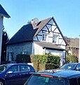
House in Bavert
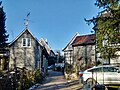
Bavert (northern part)

Bavert (northern part)

Part of the Baverter Hof


Web links
swell
- ^ City of Solingen: Street and place names in our city of Solingen , self-published, Solingen 1972
- ↑ a b Hans Brangs: Explanations and explanations for the corridor, place, yard and street names in the city of Solingen . Solingen 1936
- ↑ Manfred Kohl: Time leaps Solingen-Ohlig. Sutton-Verlag, Erfurt 2007, ISBN 978-3-86680-229-2
- ^ Topographic map of the Düsseldorf administrative district . Designed and executed according to the cadastral recordings and the same underlying and other trigonometric work by the Royal Government Secretary W. Werner. Edited by the royal government secretary FW Grube. 4th rev. Edition / published by A. Bagel in Wesel, 1859 / Ddf., Dec. 17, 1870. J. Emmerich, Landbaumeister. - Corrected after the ministerial amendments. Ddf. d. Sept. 1, 1871. Bruns.
- ↑ Johann Georg von Viebahn : Statistics and Topography of the Administrative District of Düsseldorf , 1836
- ↑ Friedrich von Restorff : Topographical-statistical description of the Royal Prussian Rhine Province , Nicolai, Berlin and Stettin 1830
- ↑ Johann Georg von Viebahn : Statistics and Topography of the Administrative District of Düsseldorf , 1836
- ↑ Royal Statistical Bureau Prussia (ed.): The communities and manor districts of the Prussian state and their population . The Rhine Province, No. XI . Berlin 1874.
- ↑ Königliches Statistisches Bureau (Prussia) (Ed.): Community encyclopedia for the Rhineland Province, based on the materials of the census of December 1, 1885 and other official sources, (Community encyclopedia for the Kingdom of Prussia, Volume XII), Berlin 1888.
- ↑ Königliches Statistisches Bureau (Prussia) (Ed.): Community encyclopedia for the Rhineland Province, based on the materials of the census of December 1, 1895 and other official sources, (Community encyclopedia for the Kingdom of Prussia, Volume XII), Berlin 1897.
- ↑ Solingen Monument List ( Memento of the original from December 18, 2015 in the Internet Archive ) Info: The archive link was inserted automatically and has not yet been checked. Please check the original and archive link according to the instructions and then remove this notice. . City of Solingen, July 1, 2015, accessed on July 3, 2016 (PDF, size: 129 kB).
Altenufer | Anchor | Auenberg | Aufderbech | Aufderhöhe | Aufm Scheidt | Bakershof | Barl | Bauermannsheide | Bavert | Bech | Gantry stairs | Börkhaus | Brabant | Broßhaus | Broßhauser Mill | Chapel | Dahl | Dahler Hammer | Diepenbruch | Deusberg | Dunkelnberg | Engelsberg | Engelsberger Hof | Fürk | Fürker Irlen | Garzenhaus | Götsche | Abomination | Hasselsheide | House | Heather | Heiligenstock | Heipertz | Honingsheide | Hübben | Sleeves | Cottage house | Valley of tears | Junker's house | Itter | Caspersbroich | Kalstert | Keusenhof | Klein-Heipertz | Little Holland | Kleinohligs | Kottendorf | Kovelenberg | Kuckesberg | Kullen | Limminghofen | Linden | Hole | Löhdorf | Maubes | Maubeshaus | Merscheid | Merscheider Busch | Monhof | Mondorf | Nassenweg | Neuenhaus | Neuenufer | Neu-Löhdorf | Obenmankhaus | Ohligs | Breakdown bottle | Pfaffenbusch | Piepers | Pohligshof | Poschheide | Poschheider Mill | Potzhof | Rennpatt | Scarf neck | Rosenkamp | Scharrenberg | Scharrenbergerheide | Scharrenberger Mill | Scouring | Schleifersberg | Lard pit | Tailors | Schorberg | Black house | Siebels | Siebelskamp | Streets | Soup heather | Deep Thick | Defiant | Downstairs house | Laugh | Waardt | Wahnenkamp | Weyer | Wiefeldick | Wilzhaus | To the Scheidt