Roßkopf (Rofan)
| Rosskopf | ||
|---|---|---|
|
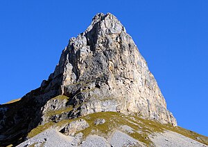
Roßkopf from the south |
||
| height | 2257 m above sea level A. | |
| location | Tyrol , Austria | |
| Mountains | Brandenberg Alps | |
| Dominance | 0.25 km → Seekarlspitze | |
| Notch height | 81 m ↓ Scharte to the Seekarlspitze | |
| Coordinates | 47 ° 27 '19 " N , 11 ° 46' 50" E | |
|
|
||
| First ascent | Ludwig Purtscheller and Professor H. Schöller from Salzburg on July 26, 1883 | |
| Normal way | from the Erfurter Hütte over the west ridge to the north summit | |
|
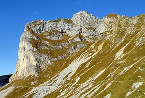
From the southwest, from the Rotspitze |
||
|
From the east |
||
The Roßkopf is in the North Summit 2257 meter high mountain in Rofangebirge , a subset of the Brandenberg Alps in the Austrian state Tirol with several peaks. The Roßkopf-Südgipfel measures only 2246 meters. Both points are connected by a very narrow ridge and are located in the main ridge of the mountains, which runs west-east here. There is also a north- east summit ( 2220 m) and an east summit (2200 m). To the west the mountain is partly overgrown with grass, to the north, east and south, however, it has rugged rock faces that are popular with alpine climbers and up to 300 meters high in the north. From the south, considered the South Summit is very massive and dominates the underlying field of Grubalacke , an extensive Kar . The Roßköpfe are easily accessible via an extensive system of hiking trails and two via ferratas and can be reached from the Erfurter Hütte , located at an altitude of 1,831 meters.
Surroundings
The Roßkopfgipfel lie in the central area of the Rofan in the main ridge that runs west-east here. Adjacent mountains are in the course of the northwest ridge , separated by the Roßkarlscharte at about 2100 m, the 2261 meter high Seekarlspitze and the Spieljoch with 2236 meters. In the east, beyond the Grubascharte (2103 m) lies the 2259 meter high Rofanspitze and in the southeast, separated by the valley basin of the Grubalacke, the Grubalackenspitze with 2169 meters. The closest place is in the south-southwest Maurach am Achensee in a good 4 kilometers as the crow flies ; Steinberg am Rofan is about 6 km to the north .
geology
See article Hochiss
Tourist development
Since the area was populated early due to its fertile soil and the Rofan Mountains are easy to climb from the south, there are no records of first ascents. A dense network of hiking trails leads through the area and the Roßkopfgipfel can be easily reached from the Erfurter Hütte , at 1831 meters north above Maurach. The normal route (slightest ascent) to the north summit leads in a north-easterly direction over the Grubastieg up to the Grubascharte at 2102 meters above sea level. From there it goes up to the Roßkarlscharte , located at around 2160 meters above sea level, over the west ridge in a good 2½ hours of walking with difficulty UIAA II and partly steep grass to the north summit. The easiest climb to the south summit (with summit cross ) leads from the Grubascharte directly over a steep grass flank on the east side in UIAA grade I to II.
Climb
The Roßkopf summit has been climbing since 1899, when Georg Leuchs , G. Heilmann and J. Schön climbed through the rugged west face of the southern summit in today's UIAA grade II . In 1909 Josef , A. and Josefine Nieberl mastered the III. UIAA grade in the northeast flank of the northeast summit. In 1926 E. Schmid and S. Moser climbed the north face with difficulty VI, but technically A2 . Until the 1980s, new routes were opened that went up to UIAA grade VIII-, A0, as in the so-called "gold rush" (SP Darshano). The last new opening so far is the route Der Name der Rose , UIAA VIII, by Hannes Salvenmoser and O. Oelze through the north face. Routes of difficulty levels IV + to VII lead through the south face. Along the route Alter Weg (IV) there has been a section of the Achensee-5-summit via ferrata in difficulty level C / D since 2010 . In the course of this, the west ridge was also expanded into a via ferrata, it has a level of difficulty B.
Literature and map
- Röder, Schmid, from Werden: Alpine Club Guide Rofan Mountains - Brandenberger Alps . Munich 1983, ISBN 3-7633-1240-4
- Hannes Salvenmoser, Mike Rutter: Rofan climbing guide . Panico-Alpinverlag, Köngen 2003, ISBN 978-3-936740-05-9
- Alpine Club Map 1: 25,000, sheet 6, Rofan
Web links
Individual evidence
- ↑ Eduard Richter : The Development of the Eastern Alps Volume 1 . Publisher of the German and Austrian Alpine Association, 1893, p. 228.
- ↑ Hannes Salvenmoser, Mike Rutter: Climbing Guide Rofangebirge . Panico, Köngen 2003, ISBN 3-936740-05-4 , pp. 176-181 .
- ↑ Achensee-5-Gipfel-Klettersteig on Achensee.info; Retrieved December 2, 2012


