Rudendorf
|
Rudendorf
community Ebelsbach
Coordinates: 50 ° 0 ′ 4 " N , 10 ° 44 ′ 43" E
|
|
|---|---|
| Height : | 310 m above sea level NHN |
| Area : | 4.41 km² |
| Residents : | 227 (1987) |
| Population density : | 51 inhabitants / km² |
| Incorporation : | May 1, 1978 |
| Postal code : | 97500 |
| Area code : | 09522 |
|
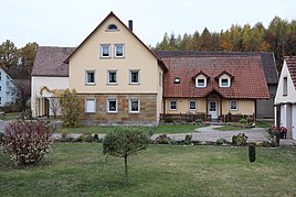
Farm in Rudendorf
|
|
Rudendorf is a district of the Lower Franconian community Ebelsbach in the Haßberge district .
geography
The village is located in the southern part of the Haßberge Nature Park . To the northeast is the approximately 461 meter high Lußberg. The Lauter flows through Ruden village and ends at Baunach in the river Baunach just before this in the Main empties. The state road 2281 from Kirchlauter to Lauter leads through the town. Bamberg is located about 20 kilometers southeast of Rudendorf.
history
The place name probably goes back to the personal name Ruodo (village of Ruodo).
Rudendorf is probably a settlement that emerged around the year 800, which belonged to the rule area of the step castle in the High Middle Ages . The lords of the castle included the Counts of Andechs-Meranien , who were followed by the Counts of Truhendingen in 1248 . The first mention of the village was in 1398 in a letter of purchase about the share of the Counts of Truhendingen over goods, including in "Rudendorff". In the 14th century, the Bamberg monastery installed the step mountain office there on the border with the Würzburg monastery . Ecclesiastically, Rudendorf belonged to the original parish of Eltmann until 1390, then to the parish of Stettfeld . The lords of Truhendingen sold Rudendorf in 1445 to the lords of Giech and in 1482 one half and in 1520 the other half of the place to the von Rotenhan zu Rentweinsdorf . In the course of the Peasants' War a battle is said to have taken place near Rudendorf. In 1532 the von Rotenhan had jurisdiction in "Rudtendorff" and in 1621 they had "Rudendorff" as a Würzburg fief . Hans von Rotenhan introduced the Reformation in 1533/34. As a result of the Thirty Years War , Rudendorf was uninhabited in 1644. In 1691 the von Rotenhan family founded a school. The schoolhouse was built around 1820.
In 1862 the rural community of Rudendorf was incorporated into the newly created Bavarian District Office Ebern and the Baunach Regional Court . Rudendorf counted 55 residential buildings and 279 inhabitants in 1871, of which 47 were Catholics and 232 Protestants. In 1900 the 440.89 hectare community had 291 residents and 54 residential buildings. The Catholic residents belonged to the parish of Kirchlauter, which is 5.0 kilometers away , and the responsible denomination school was located in Lußberg . The Protestant residents had belonged to the parish in Gleisenau, 6.0 kilometers away, since 1808 . In 1925 there were 298 people in Rudendorf, including 65 Catholics, 232 Protestants and one Jew, in 54 residential buildings. In 1950 the village had 320 residents and 51 residential buildings. In 1970 there were 241 residents and in 1987 227 residents and 63 residential buildings with 72 apartments.
Rudendorf has been part of the Ebelsbach community since May 1, 1978.
Attractions
The Evangelical Lutheran Michaelskirche was built in 1953–1954 according to plans from 1941 on the so-called Schlossberg. A previous church built in 1616 was demolished in 1764 after it fell into disrepair.
Web links
Individual evidence
- ↑ a b Bavarian State Office for Statistics and Data Processing (Ed.): Official local directory for Bavaria, territorial status: May 25, 1987 . Issue 450 of the articles on Bavaria's statistics. Munich November 1991, DNB 94240937X , p. 361 . ( Digitized version ).
- ↑ a b c Werner Schmiedel: Districts Ebern and Hofheim. In: Historical book of place names of Bavaria. Lower Franconia. Volume 2: Districts of Ebern and Hofheim. Commission for Bavarian State History, Munich 1973, ISBN 3-7696-9872-X , p. 47.
- ↑ a b c VG Ebelsbach: Ebelsbach and its district of Rudendorf
- ↑ Kgl. Statistical Bureau (ed.): Complete list of localities of the Kingdom of Bavaria. According to districts, administrative districts, court districts and municipalities, including parish, school and post office affiliation ... with an alphabetical general register containing the population according to the results of the census of December 1, 1875 . Adolf Ackermann, Munich 1877, 2nd section (population figures from 1871, cattle figures from 1873), Sp. 1297. , Urn : nbn: de: bvb: 12-bsb00052489-4 ( digitized ).
- ↑ K. Bayer. Statistical Bureau (Ed.): Directory of localities of the Kingdom of Bavaria, with alphabetical register of places . LXV. Issue of the contributions to the statistics of the Kingdom of Bavaria. Munich 1904, Section II, Sp. 1310 . ( Digitized version ).
- ↑ Bavarian State Statistical Office (ed.): Localities directory for the Free State of Bavaria according to the census of June 16, 1925 and the territorial status of January 1, 1928 . Issue 109 of the articles on Bavaria's statistics. Munich 1928, Section II, Sp. 1344 . ( Digitized version ).
- ↑ Bavarian State Statistical Office (ed.): Official place directory for Bavaria - edited on the basis of the census of September 13, 1950 . Issue 169 of the articles on Bavaria's statistics. Munich 1952, DNB 453660975 , Section II, Sp. 1177 . ( Digitized version ).
- ^ Bavarian State Statistical Office (ed.): Official place directory for Bavaria . Issue 335 of the articles on Bavaria's statistics. Munich 1973, DNB 740801384 , p. 187 . ( Digitized version ).

