Ruta 1 (Chile)
| Ruta 1 in Chile | |||||||||||||||||||||||||||||||||||||||||||||||||||||||||||||||||||||||||||||||||||||||||||||||||||||||||||||||||||||||||||||||||||||||||||||||||||||||||||||||||||||||||

|
|||||||||||||||||||||||||||||||||||||||||||||||||||||||||||||||||||||||||||||||||||||||||||||||||||||||||||||||||||||||||||||||||||||||||||||||||||||||||||||||||||||||||
| map | |||||||||||||||||||||||||||||||||||||||||||||||||||||||||||||||||||||||||||||||||||||||||||||||||||||||||||||||||||||||||||||||||||||||||||||||||||||||||||||||||||||||||
| Basic data | |||||||||||||||||||||||||||||||||||||||||||||||||||||||||||||||||||||||||||||||||||||||||||||||||||||||||||||||||||||||||||||||||||||||||||||||||||||||||||||||||||||||||
| Operator: | Autopista Rutas del Desierto ( Iquique - Aeropuerto Diego Aracena ) | ||||||||||||||||||||||||||||||||||||||||||||||||||||||||||||||||||||||||||||||||||||||||||||||||||||||||||||||||||||||||||||||||||||||||||||||||||||||||||||||||||||||||
| further operator: | Autopistas de Antofagasta (connection north Mejillones - Antofagasta ) | ||||||||||||||||||||||||||||||||||||||||||||||||||||||||||||||||||||||||||||||||||||||||||||||||||||||||||||||||||||||||||||||||||||||||||||||||||||||||||||||||||||||||
| Overall length: | 598.6 km | ||||||||||||||||||||||||||||||||||||||||||||||||||||||||||||||||||||||||||||||||||||||||||||||||||||||||||||||||||||||||||||||||||||||||||||||||||||||||||||||||||||||||
|
Región (region): |
|||||||||||||||||||||||||||||||||||||||||||||||||||||||||||||||||||||||||||||||||||||||||||||||||||||||||||||||||||||||||||||||||||||||||||||||||||||||||||||||||||||||||
| Development condition: | 1 × 2 lanes, 2 × 2 lanes between Mejillones and Antofagasta |
||||||||||||||||||||||||||||||||||||||||||||||||||||||||||||||||||||||||||||||||||||||||||||||||||||||||||||||||||||||||||||||||||||||||||||||||||||||||||||||||||||||||
|
Course of the road
|
|||||||||||||||||||||||||||||||||||||||||||||||||||||||||||||||||||||||||||||||||||||||||||||||||||||||||||||||||||||||||||||||||||||||||||||||||||||||||||||||||||||||||
The Ruta 1 ( RN 1 for short ) is a trunk road in the South American Andean state of Chile . It is called Ruta 1 Costera.
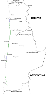
Ruta 1 is located in the north of Chile in the Tarapacá and Antofagasta regions . In its course of 598.6 km it connects Iquique with the Ruta 5 by a road parallel to the Pacific coast. It connects two of the most important cities in northern Chile. It also serves as an alternative route to the Panamericana , which runs through the Atacama Desert .
The official function of this longitudinal axis was ratified in 2000 by Decree Nº 2136 by the Ministerio de Obras Públicas de Chile (MOP).
course
The longitudinal axis begins in Iquique. From this town, the route is completely paved to the area around Caleta Coloso, south of the regional capital, Antofagasta. The Pedro Galleguillos tunnel (north of Tocopilla ), which was built in 1994 as an alternative to the Paquica Pass, is on the route mentioned. The tunnel has undergone a number of repairs since the year it was built, mainly after the Tarapacá earthquake in 2005.
From Puerto Coloso to the southeast, the road is interrupted and then bears the same name again from Caleta El Cobre. The alternative further south is the Ruta 5, via the connection at Antofagasta through the middle of the desert , then via the Ruta B-70 until you reach Paposo. From Caleta Blanco Encalada to Paposo, Ruta 1 is a paved road, from there to the end it is paved again. It ends at the junction with Ruta 5.
Cities and towns
The direct connections to cities, towns and urban areas along this road from north to south are:
Tarapacá region
Length: 143 km (km 410 to km 267). In the southern urban area of Iquique, the street is called Avenida Arturo Prat.
- Provincia de Iquique (the kilometer points are counted from Antofagasta, both north and south): continues as Autopista Rutas del Desierto, connection to Playa Aguadita (km 364), connection to Yape (km 361), connection to Caleta Caramucho ( km 360), connection to Caleta Chanavayita (km 356), Puerto de Patillos (km 352), connection to Caleta Patache (km 346), Puerto Punta Patache (km 345), connection to Caleta Chanabaya (km 338), connection to Caleta Pabellón de Pica (km 334), Caleta Río Seco (km 320-319), Caleta San Marcos (km 304), customs of El Loa and mandatory police control of the Carabineros de Chile (km 264).
Antofagasta region
Length: 281 km (km 267 to km 0, km 0 to km 14). In Tocopilla, the inner-city section runs along Avenida Teniente Merino, Avenida Arturo Prat and Avenida Doctor Leonardo Guzmán. Meanwhile, the street in the north of Antofagasta is called Avenida Edmundo Pérez Zujovic and in the south Avenida Universidad de Chile.
- Provincia de Tocopilla (the kilometer points are counted from Antofagasta, to the north and south): Caleta del Norte (km 252), connection to Caleta Punta Arenas (km 240 and 239), Caleta Quebrada Honda (232–233), Caleta Punta del Urcu (km 227-224), connection to Caleta Paquica (km 209), Tocopilla (km 185-181), Caleta Boy and control of the Carabineros de Chile (km 181-180), connection to Punta Blanca (km 175) , Connection to Caleta Punta Atala (km 160), Caleta Indígena (km 152), connection to Caleta Buena (km 142), Gatico (km 133), connection to Cobija (km 129).
- Provincia de Antofagasta : Caleta Michilla (km 107), connection to Hornitos (km 90), connection to Hornitos and Caleta Punta Itata (km 81), connection to Caleta Chacaya (km 76), continued as Autopistas de Antofagasta, Antofagasta (km 6 -0).
- Provincia de Antofagasta : Antofagasta (km 0–5), Caleta Coloso (km 8–9), connection to Puerto Coloso (km 10).
Length: 173 km (km 173 to 0). In the urban area of Taltal , Ruta 1 leads over Avenida Manuel Antonio Matta and Avenida Francisco Bilbao.
- Provincia de Antofagasta (the kilometer points are counted from the Las Breas intersection, to the north): Caleta El Cobre (km 173), connection to Caleta Blanco Encalada (km 158), connection to Caleta Botija (km 140), connection to Caleta Colorada (km 122), El Médano (km 97), Caleta Rincón (km 84), connection to Paposo (km 75 and km 74), connection to Caleta Punta Grande (km 65), connection to Caleta Bandurria (km 51 and km 50 ), Connection to Caleta Oliva (km 37), connection to Caleta Hueso (km 25), valley (km 24-22).
business
The Autopista Rutas del Desierto between Iquique and Aeropuerto Diego Aracena Airport is currently under construction. A section of the operator Autopistas de Antofagasta has already been inaugurated, between the connection north to Mejillones and the capital of the region, Antofagasta.
Individual evidence
- ↑ a b Red vial en la Región de Tarapacá en Dirección de Vialidad Chile ( Memento of the original dated August 31, 2011 in the Internet Archive ) Info: The archive link was inserted automatically and has not yet been checked. Please check the original and archive link according to the instructions and then remove this notice.
- ↑ Red vial en la Región de Antofagasta en Dirección de Vialidad Chile ( Memento of the original dated August 31, 2011 in the Internet Archive ) Info: The archive link was inserted automatically and has not yet been checked. Please check the original and archive link according to the instructions and then remove this notice.
- ↑ a b c Decretos supremos que declaran caminos públicos en Dirección de Vialidad Chile ( Memento of February 28, 2014 in the Internet Archive )
- ^ Concesión Autopistas de Antofagasta
