
Süddorf (Amrum)
|
South village
Nebel municipality
Coordinates: 54 ° 38 ′ 28 ″ N , 8 ° 21 ′ 20 ″ E
|
||
|---|---|---|
| Height : | 10 m | |
| Residents : | 300 (115) | |
| Incorporation : | May 25, 1987 | |
| Postal code : | 25946 | |
| Area code : | 04682 | |
Location of Süddorf in Schleswig-Holstein |
||
 Row of houses in Süddorf
|
||

Süddorf (Frisian Sössaarep, Danish Sydtorp ) is a district of the municipality Nebel on the North Sea island of Amrum .
geography
Süddorf is located in the south of the island, around one kilometer south of Nebel, 1.5 kilometers west of Steenodde and three kilometers northwest of Wittdün . The place extends mainly in an east-west direction and has around 300 inhabitants. In the west there is a parking lot, from which a footpath leads through the nature reserve " Amrumer Dünen " to Kniepsand , the Amrumer beach. The Großdün residential area is located south of Süddorf .
As of the date of the census on May 25, 1987, Süddorf had 115 inhabitants in 53 households.
history
Süddorf was already settled in prehistoric and early historical times. Several Bronze Age burial mounds and the 1,800-meter-long Krümwal , an earth wall that probably dates from the Viking Age , bear witness to this .
In 1464, Süddorf was first mentioned together with Norddorf as Suder , but is much older. A map from 1799 shows several large farms in Süddorf, including the former home of the seafarer Hark Olufs , who was born in Süddorf, rose to high positions as a slave in North Africa and finally returned to his home village, where he died in 1754.
In 1875 the Amrum lighthouse was inaugurated on the southern edge of the southern part of the village. After the Heligoland lighthouse at 63 meters above sea level, it has the second highest lighthouse on the German North Sea coast and is protected as a monument. He stands on a 27 meter high dune . The range is 23.3 nautical miles . Due to its size and the characteristic red and white paint, the lighthouse is the most distinctive building on the island of Amrum.
1882 on the grave mound Reddenhugh the windmill with cod end " Bertha " built in 1775 for Munkmarsch on Sylt had stood. In 1893 it was converted into a Dutch windmill with sail gate blades and was in operation until 1939. Since then it has served as a residential building.
After the Second World War, the place grew mainly towards the heathland in the west. In 1968 the “Amrum Village Community School” was inaugurated in the north-east of the southern village, bringing together the schools on the island. It has been called Öömrang Skuul ( Öömrang ; German: "Amrumer Schule") since 2002 and is a primary and regional school with a support center . Around 200 students attend the school.

Amrum lighthouse

Süddorfer windmill

Öömrang Skuul
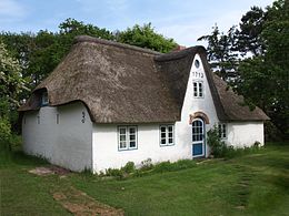
Uthland Frisian house from the 18th century on Uasterstigh

Heeshugh burial mound (Bronze Age), in the background the Nebeler Windmill

Hark Olufs' tombstone in fog


Economy and Transport
The main line of business in Süddorf is tourism. Agriculture is also practiced.
Süddorf is on the national road 215, which connects almost all of the island's towns. Another country road leads to Steenodde. Süddorf is regularly served by bus, every half hour in summer. The Amrum Island Railway served Süddorf on a route to the west until it was closed in 1939.
Sons and daughters of the place
- Hark Olufs (1708–1754), navigator
Web links
Individual evidence
- ^ Eva Missler: Sylt Amrum Föhr. Digitized version (excerpt) , accessed on April 22, 2017
- ↑ State Statistical Office Schleswig-Holstein: Housing Directory Schleswig-Holstein 1987, Kiel 1992 , p. 38
- ↑ a b Georg Quedens : Amrum. Breklumer Verlag, Breklum 1971, without ISBN, p. 56f.
- ↑ Erich Pörksen: The landmarks of the island of Amrum. P. 69 f .: The mill in Süddorf
- ^ Website of Öömrang Skuul , accessed on August 2, 2013
- ↑ Öömrang Skuul , accessed on May 17, 2019