Southern Göriach redness
| Southern Göriach redness | ||
|---|---|---|
|
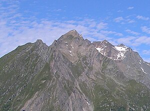
Ochsenbug (center) with southern and northern Göriacher Röte (right) seen from the east |
||
| height | 3020 m above sea level A. | |
| location | Tyrol , Austria | |
| Mountains | Frosnitzkamm , Venediger Group | |
| Dominance | 2.9 km → Raukopf | |
| Notch height | 252 m ↓ Firschnitzscharte | |
| Coordinates | 47 ° 2 ′ 21 ″ N , 12 ° 28 ′ 0 ″ E | |
|
|
||
| First ascent | unknown | |
| Normal way | from Firschnitztal into the Scharte located in the west ridge and over the northern Göriacher Röte ( II ) | |
The southern Göriacher Röte , formerly also called Bretterspitze or Gattenkogel , is 3020 m above sea level. A. high mountain peak in the Frosnitzkamm of the Venediger group in the north of East Tyrol . The first ascent of the southern Göriacher Röte has not been recorded; A. Santner, H. Schneeberger and W. Trost made the first crossing on September 4, 1932 as a ridge crossing from Ochsenbug.
location
The southern Göriacher Röte lies in the east of the Venediger group or in the center of the Frosnitz ridge on the municipality border between Matrei in East Tyrol in the east and Virgen in the west. The southern Göriacher Röte is located in the core zone of the Hohe Tauern National Park in the area of the Virger Nordkette , which delimits the municipality of Virgen to the north. South of the southern Göriacher Röte is the Bretterspitze ( 3001 m above sea level ), also called Hinterer Misenok, to the north is the northern Göriacher Röte ( 3011 m above sea level ). There are no named notches to the two neighboring peaks, the closest notches in the ridge course are the Firschnitzscharte in the northwest ( 2769 m above sea level ) and the Mellitzscharte ( 2995 m above sea level ) in the southeast. On the east side of the summit, the Fritschnitzkees extends between Nördlicher Göriacher Röte and Bretterspitze. The closest refuge is the Bonn-Matreier-Hütte , the closest villages are the Virg districts of Marin and Mellitz in the south.
Promotion opportunities
The normal route to the southern Göriacher Röter leads from Marin to the north into the valley of the Firschnitzbach . Before the Firschnitzscharte, the path crosses to the right into a notch in the western ridge of the Nördliche Göriacher Röte, via which one reached the Nördliche Göriacher Röte ( II ). The transition to the southern Göriacher Röte is a walking area. There are alternative routes via the east-south-east ridge or crossing the Ochsenbug.
Individual evidence
- ↑ Clem Clements, Jonathan de Ferranti, Eberhard Jurgalski , Mark Trengove: The 3000 m SUMMITS of AUSTRIA - 242 peaks with at least 150 m of prominence , October 2011, p. 16.
- ↑ AV Guide
- ↑ Federal Office for Metrology and Surveying Austria: Southern Göriacher Röte on the Austrian Map online (Austrian map 1: 50,000) .
literature
- Willi End , Hubert Peterka : Alpine Club Leader Venediger Group. Bergverlag Rother , 5th edition 2006, ISBN 3-7633-1242-0 , p. 290.
- Georg Zlöbl: The three thousand meter peaks of East Tyrol in the Hohe Tauern National Park . Verlag Grafik Zloebl, Lienz-Tristach 2007, ISBN 3-200-00428-2 .
- Alpine Club Map 1: 25,000, sheet 36, Venediger Group , ISBN 3-928777-49-1 .

