
Landscape protection area Salzachsee-Saalachspitz
Coordinates: 47 ° 51 ' N , 13 ° 1' E

The Salzachsee-Saalachspitz conservation area is a conservation area in the northwest of the city of Salzburg in the Liefering district . The area around the Salzachsee with other small lakes as well as the so-called Saalachspitz , the headland tapering to the north at the confluence of the Saalach and Salzach , the two main rivers of the state of Salzburg, are important geographical objects .
geography
Position and extent

The landscape protection area is located at the north-western end of the city of Salzburg in the north of the Liefering district on the left bank of the Salzach, which thus forms the entire eastern boundary. The border of the protected area in the south-east and south is the Theodostraße, the Schmiedingerstraße running in a northerly direction up to the level of the Karlsbader Weiher and then the Fischergasse leading back south to about the level of the Altglan, after which the boundary continues across the so-called Lehenauen to the Troellenweg . In the south-west, the protected area is bounded by the trout trail to the north of the trout trail settlement and then to the Saalach , which then forms the entire westward end until it joins the Salzach.
The salt axis settlement is located on the southern edge of the protected area . Excluded from the protected area is a built enclave in the so-called Herrenau in the west .
The protected area has an area of 184.4 hectares (ha) and is located in the cadastral municipality of Liefering II at around 410 m above sea level. A. The northern part, the headland tapering to the north at the confluence of the Saalach and Salzach, is known locally as the Saalachspitz. The eastern boundary through the Salzach forms in the extreme northern section at the same time the city boundary with the municipality of Bergheim , the Saalach in the west is also the state border with Bavaria over its entire length; opposite is the city of Freilassing .
Land use and bodies of water

The protected area lies on a gravel plain over sea clay and flysch rock from the Upper Cretaceous period . In the area of the landscape protection area, the current land use is predominantly in the form of meadows and some fields as well as a forest edge of different widths along the Saalach and Salzach. The Saalachspitz is largely forested. In addition, there is an allotment garden settlement of around 4.6 hectares in the protected area as well as a 4000 m² orchard meadow created by a local initiative in 2014.
In Herrenau, part of the landscape protection area is built with sports facilities.

The Altglan flows through the area to the north in a largely natural bed, this is the lowest section of the Glan , which also flows into the Salzach almost 800 m south of the Saalach confluence. The Lieferinger Mühlbach flows into the Altglan in the southernmost part of the protected area.
In the southeastern part of the landscape protection area is the Salzachsee with a few other lakes, which are often referred to collectively as the Salzachseen. Of these, the Liefering bathing lake and the Karlsbader Weiher are of particular importance. These are quarry ponds that were created in the 20th century.
history
At the beginning of the 19th century, the area that is now protected was still characterized by the extensive tributaries of the Saalach and Salzach. The numerous gravel banks in between were flooded every year at high tide, and the terrain kept changing. After 1816 a new border between the Kingdom of Bavaria and now Austria allocated Duchy of Salzburg had been decided to establish a fixed boundary line was due for military reasons. This should be in the middle of the Saalach and after its confluence with the Salzach it should continue in the middle. So it was decided to take regulatory measures to create a fixed bed for these rivers. The prospect of containing the flood damage as well as the reclamation of dry land for agricultural and structural purposes also contributed to the decision, not least for fiscal reasons. The route was determined after mapping carried out between July and November 1817. The deepening of the main channel over the next few decades resulted in the successive drying of the tributaries of the rivers. The last measurement of the boundary line took place in the 1950s.
Immediately north of the confluence of the Saalach and Salzach rivers, a ferry service still existed around 1930 between Salzburghofen, which today belongs to Freilassing, and the town of Muntigl, which belongs to Bergheim .
Soon after Austria was annexed to Nazi Germany in 1938, the construction of the planned Reichsautobahn to Vienna, today's Westautobahn ( A1 ), began. In the course of this, the clearing and excavation of earth for the motorway embankment began in the eastern and south-eastern areas of today's protected area . Largest of the resulting quarry ponds, which were soon used for swimming, was the Salzachsee, whose name was a temporary arrangement that remained. Under the title “The Salzach Lake. Leopoldskron has had competition "is reported in the press:
“In the meantime we have called the lake 'Salzach Lake'. It is very close to the Salzach, and there is not just a spatial, but also an 'inner' connection: due to the same water level, because the groundwater level is based on the water level of the Salzach. For the time being, however, the lake could also be called the Reichsautobahn lake, until a poetic name is found. "
Already at this time there is talk of a future local recreation area with a beach, playgrounds, sun terraces and a possible hotel.
In the 1950s, gravel was also extracted in this area for residential purposes. The present protection area was also used as a garbage dump in various places over the next two decades . Precautions regarding environmental protection, in particular water pollution, have not been taken, so that these places are now partially observed as contaminated sites . With regard to the already limited construction activity in the landscape protection area, additional guidelines must be observed.
Contaminated sites
With regard to environmental protection, two areas are under observation as contaminated sites:
- The contaminated site Salzachsee-Nord is the area north of the bathing lake Liefering up to the Saalachspitz. From 1959 onwards, household waste and building rubble were deposited on around 138,000 m², and from 1977 to 1985 garden waste, street sweepings and excavated earth were deposited. The more than 10 m thick deposits were made without any precautions to protect the groundwater. In some places - with a decreasing tendency - landfill gas is formed and the groundwater quality is impaired. The groundwater available here is not used. In autumn 2003 the area was declared a contaminated site. The area is now a green area.
- The Herrenau contaminated site is located in the west of the protected area. The former Herrenau landfill comprised an area of around 114,000 m², in which building rubble, bulky waste, and commercial and industrial waste were deposited from 1973 to 1979. There is little landfill gas formation and an impairment of the groundwater, which, however, is not used. The area was declared a contaminated site in February 1999. The Lieferinger allotment garden is located on the site today.

The old Salzachsee-Süd dump is a former 114.00 m² gravel pit, in which household waste, construction rubble and excavated material were deposited from 1959 to 1977. The area under observation was removed from the suspected land register by the Federal Environment Agency in mid-2010 , but is still listed as a Registered Old Deposit. For safety reasons, the precautionary measures that also apply to the contaminated areas continue to apply to the area on which the Lieferinger fish pond and the Salzachsee are located today.
The surface waters in the entire landscape protection area are located outside or above the old deposits.
Protected position
Large areas of the garbage dump near the Salzach were closed in 1966 and gradually recultivated from 1967 onwards and gradually transformed into a recreational landscape. On July 1, 1967, the Salzachsee nature reserve was established. The restoration of the dusty and extensively devastated landscape was celebrated as a great achievement. After the landfill was placed under protection, the pressure from the population increased so that the landfill was finally closed in 1977.
The protected area was significantly enriched on May 1, 1982 by including the near-natural meadow and alluvial forest landscape bordering the salt axis to the west. However, this also included the area of what is now the Herrenau contaminated site, which was used for waste disposal until 1979. Since this expansion, the area has been called the "Salzachsee-Saalachspitz Landscape Protection Area" and is recorded in the Salzburg State's nature conservation book under the number LSG 00055 .
The purpose of protection is “the preservation of 1. the particular scenic beauty […] (meadow landscape with its streams and wooded borders, parkland with lakes and ponds, alluvial forest border); 2. the significant experience and recreational value of the cultural landscape characteristic of the Salzburg city area, which borders on the densely built-up settlement area Lehen / Liefering ”.
On the one hand, the city of Salzburg has endeavored for decades to maintain the largest possible green space in the city area and on the periphery of the neighboring communities; The Salzachsee-Saalachspitz conservation area is one of the city's oldest conservation areas , alongside the Hellbrunn conservation area, which was also established in 1967 (today part of the Salzburg-Süd conservation area). On the other hand, there are exemptions for the construction of buildings and systems in protected areas. In the Salzachsee-Saalachspitz landscape protection area, the Red Bull Group approved the construction of a professional football academy at the end of 2008, contrary to popular protests , which was subsequently built on the site of the former harness racing track in Herrenau. An expansion for the ice hockey segment followed a few years later.
Redesign of the Saalachspitz in 2014
At the beginning of June 2013, the Saalach and Salzach caused severe flooding, which resulted in massive damage to buildings, infrastructure and the bank protection of the two rivers. Damage to the right Saalachzeile, the access road to Herrenau, was repaired immediately after the flood. Further measures were necessary to improve the stability of the riverbed of the Saalach and the flood protection in the entire area. From January 2014 to January 2015 renovation work was carried out on an area of 19 ha; the construction costs of 3.8 million euros were financed entirely from federal funds.
In order to widen it, parts of the bank protection of the Salzach were removed, two flood troughs were created between Saalach and Salzach and the stairway paths along the rivers were re-routed. The mouth of the Altglan has been completely redesigned by diverting the course of the stream almost 250 m above the confluence and then dividing it into two separate arms, 680 and 280 m long, running parallel to the Salzach. With the construction measures, a new body of water of around 3 hectares with a length of 1.2 km was created.

The Saalachspitz 2011 - looking south from the Freilassing side

The Saalachspitz 2015 - looking south, left: Salzach, right: Saalach
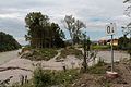
A flood basin built in 2014 between Saalach (left) and Salzach
.jpg)


nature
The flora of the protected area is characterized, among other things, by tree species such as white and black poplar , various types of willow , gray alder , sycamore maple and English oak as well as various shrubs such as woolly snowball , wild wine , hawthorn , dogwood and arum .
Hedgehogs , squirrels and several species of ducks and geese are typically represented from the animal kingdom . In the Karlovy Vary pond there are also several species of fish such as pike , pikeperch and chub .

In the alluvial forest of the Saalachspitz

At the Karlsbader pond

At the Salzachsee

In the alluvial forest of the Saalachspitz


Infrastructure and use of the landscape

Both along the Salzach and the Saalach, a footpath and cycle path leads to the Saalachspitz, the extreme end of which has shared access from both sides of the river since the renovation in 2014. The paths are suitable for jogging and Nordic walking . The construction of the Munitgl power plant is planned on the Salzach at the height of the extreme tip area.

The protected area in the southeastern part, where the larger lakes are located, is most frequently visited, primarily for recreation, swimming and fishing. Riding out with horses is also carried out from a riding stable in Herrenau. The Karlsbader Weiher and the Liefering fish pond serve as fishing waters. At the bathing lake Liefering there are bathing-related facilities and a kiosk. Next to the lake is the Salzachsee Nord children's playground and the Salzachsee Süd children's playground south of the Liefering fish pond. There is also a mini golf course northwest of the salt axis. Since 2012, there has been an approximately 4000 m² dog run area behind the Lieferinger bathing lake.
The setting up of tents in the area of the protected area is not permitted by law.
On the main access road to the natural area, Schmiedingerstraße, there are two parking spaces for private vehicles. The area can be reached by public transport with the urban trolleybus line 7 (stop Theodostraße and terminus Salzachsee ).
Web links
Individual evidence
- City of Salzburg: Salzachsee landscape protection area , accessed on August 15, 2015.
- Nature Conservation Book of the State of Salzburg - Landscape Protection Area Salzachsee-Saalachspitz , accessed on September 4, 2017.
- ↑ So the marking according to the nature conservation book of the State of Salzburg. The city of Salzburg also designated this area as the Salzachsee landscape protection area in its original name (cf. website of the Salzburg Magistrate ( Memento of the original from March 19, 2015 in the Internet Archive ) Info: The archive link was inserted automatically and has not yet been checked. Please check Original and archive link according to instructions and then remove this note. , Accessed on August 15, 2015).
- ↑ See erdling.at ( Memento of the original from September 24, 2015 in the Internet Archive ) Info: The archive link was inserted automatically and has not yet been checked. Please check the original and archive link according to the instructions and then remove this notice. , accessed on August 16, 2015.
- ↑ On flow regulation and the drawing of boundaries, cf. The Lieferinger Kulturwanderweg , ed. from the Salzburg-Liefering District Museum Association. [O. V.] Salzburg 2006, p. 174ff. as well as Liefering. The Village in the City , ed. from the board of trustees of the Peter Pfenninger donation Liefering, [o. V.] Salzburg 1997, p. 413.
- ↑ This refers to the Leopoldskroner Weiher , which was then also used as a bathing lake, next to Leopoldskron Castle in the south of Salzburg.
- ↑ Quotation from Liefering. The village in the city. Published by the Board of Trustees of the Peter Pfenninger Donation, [o. V.] Salzburg 1997, p. 204.
- ↑ Detailed information in: Federal Environment Agency: Altablagerung Salzachsee-Nord ( Memento of the original from March 4, 2016 in the Internet Archive ) Info: The archive link was inserted automatically and has not yet been checked. Please check the original and archive link according to the instructions and then remove this notice. , 2003, accessed August 15, 2015.
- ↑ See Federal Environment Agency: Altlast S 11 Landfill Herrenau , accessed on August 15, 2015.
- ↑ Landscape protection area Salzachsee-Saalachspitz in the nature reserve book of the state of Salzburg
- ↑ See Aktion Grünland Salzburg ( page can no longer be accessed , search in web archives ) Info: The link was automatically marked as defective. Please check the link according to the instructions and then remove this notice. , accessed August 15, 2015.
- ↑ Data and facts about the construction work according to two freely accessible information boards in the area of the Saalachspitz; As of July 2015.
- ↑ Measurement on the OpenStreetMap ; the new course of the brook has not yet been recorded in the official geographic information system of the state of Salzburg (SAGIS) (as of August 16, 2015).
- ^ Water Book of the State of Salzburg; Marking in the official geographic information system of the State of Salzburg (SAGIS), layer water ; As of August 16, 2015.