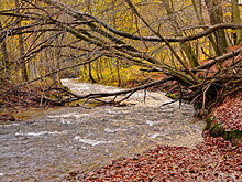
Gelpe Valley

The Gelpe Valley , together with the Saalbach Valley, forms a wooded local recreation area in the south of the city of Wuppertal on the border with Remscheid .
The two brooks Gelpe and Saalbach unite in the lower Gelpe Valley , known as the Zillertal, and shortly afterwards flow into the Morsbach , one of the larger tributaries of the Wupper .
Industrial historical significance

Finds of ore mining sites and kilns in the Gelpe Valley , which according to the Wuppertal Historical Center are dated back to the 10th century, show that iron was already being processed in the valley in the early Middle Ages . According to some etymologists , watercourses with the endings -apa , -epe , -pe and -fe can be traced back to the ancient Germanic word “Apa” , which stands for “stream” or “body of water”. (The earlier interpretation as a Celtic ending was abandoned because there is insufficient evidence of the Celts in the Wupperbogen.) The name Gelpe suggests that these streams existed before the settlement of the Bergisches Land , between the 7th and 9th centuries used, were known.
Iron and steel have been industrially processed on the streams and rivers in the Wuppertal, Remscheider and Solingen areas since the 14th century. In the area of these three cities, several hundred hammer mills and grinding cabins settled , which used the region's hydropower until the beginning of the 20th century .
Although the degree of industrialization in the area has been one of the highest in the entire German-speaking area since the 17th century due to the abundance of water in the region , the entire industrial output was distributed among numerous individual workshops in which high-quality steel is refined from iron blanks and further into sickles , scythes , Tools , swords and other cutlery was further processed. The pig iron was imported from the Siegen area via the Bergische Eisenstraße , the charcoal for the forges was extracted on site in coal piles.
The products were then sold all over Europe . It was only with the advent of steam engines (later electric motors ) and the construction of coal routes from the Ruhr area (later railways ) that the companies left the narrow, damp and dark valleys and settled on the mountain ranges with better transport connections.
One of the coal routes also led through the Gelpe Valley and, from the late 19th century, provided the delivery of hard coal for the steam engines set up to replace the unsafe water power.
The Gelpe and the Saalbach (see also Ronsdorfer Dam ) hosted on their runs a variety, like pearls on a chain strung together grinding cotta and hammers from the early history of the industrialization of the low mountain range Bergisches Land , which initially took advantage of the flowing water as a drive. Some plants were expanded to small factories with tall meals and large workshops by the middle of the 20th century .
In the order from the source to the mouth they are:
- Bacon hammer
- Pickardtskotten
- Upper Jansenkotten
- Cremerskotten
- Master hammer
- Teschenkotten
- Lower Jansenkotten
- Tippelskotten
- Jasperskotten
- Käshammer (Höltershammer)
- Mühlenbergerkotten
- Büngershammer
- Friedrichshammer
- Puppy dog
- Wolfert's Hammer
- Westerhammer
- Reinshagenshammer
- Neuenkotten
- Steffenshammer
- Schliepershammer
- Rottsiepers hammer
Today these structures have almost all completely disappeared, only dams and moats have been partially preserved, most of which are protected as ground monuments due to their regional industrial-historical importance . The cheese hammer has been lovingly restored. The Steffenshammer with a functioning, overshot water wheel in the Remscheid town of Clemenshammer am Unterlauf housed a branch of the German Tool Museum / Historical Center of the city of Remscheid and is now looked after by a support association.
The industrial history trail in the Gelpe-Saalbach area, inaugurated in 1980, explains the individual historical sites and their function on boards.
Gelpetal as a relaxation area
Since the end of the 19th century, the Gelpe and Saalbachtal have increasingly taken on the function of a local recreation area. The construction of the Ronsdorf dam made a lasting contribution to the attractiveness of the area and attracted a large number of visitors after its completion. Although the valleys were purely an industrial area, the workshops were individually located in the forest and, with their moats and reservoirs, offered picturesque cultural landscapes that were ideal for walks. Excursion restaurants ( Bergisch Nizza , Gelper Hof , Käshammer , Büngershammer , Zillertal ) established themselves and ensured a further increase in the number of visitors.
Today a dense network of hiking trails guides walkers through the landscape.
Nature reserves
Almost the entire course of the Gelpe and Saalbach streams is designated as a nature reserve and fauna-flora-habitat, the Gelpe and Saalbach valley, despite its former industrial use . The nature reserves in Wuppertal cover an area of about 133 hectares and in Remscheid about 22.7 hectares.
literature
- Egon Viebahn; Hammers and grinding balls in the Gelpetal ; Born publishing house; Wuppertal 1983; ISBN 3-87093-033-0 (extended new edition 2003)
- Günther Schmidt; Hammer and Kotten research in Remscheid , Volume 3: from Gerstau to Haddenbach with Gelpetal and Ibach ; Publisher: Buchhandlung R. Schmitz; Remscheid; 2002; ISBN 3-98000773-1
Individual evidence
- ↑ Natura2000 area DE-4709-303 "Gelpe and Saalbach" ( Memento from September 30, 2007 in the Internet Archive )
- ↑ NSG BK-4708-921 "Gelpe- und Saalbachtal river system" (Wuppertal) ( Memento from September 30, 2007 in the Internet Archive )
- ↑ NSG BK-4708-904 "Gelpe-Saalbach" (Remscheid) ( Memento from September 30, 2007 in the Internet Archive )
Web links
- Nature reserve “Gelpetal” (W-015) in the specialist information system of the State Office for Nature, Environment and Consumer Protection in North Rhine-Westphalia
Coordinates: 51 ° 13 ′ 18 ″ N , 7 ° 9 ′ 45 ″ E


