
Saalsdorf
|
Saalsdorf
Community Bahrdorf
Coordinates: 52 ° 21 ′ 34 " N , 11 ° 3 ′ 32" E
|
||
|---|---|---|
| Height : | 79 m above sea level NHN | |
| Incorporation : | July 1, 1972 | |
| Postal code : | 38459 | |
| Area code : | 05358 | |
Location of Saalsdorf in Lower Saxony |
||
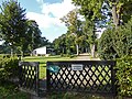
 Entrance
|
||

Saalsdorf is a district of the municipality of Bahrdorf , in the Helmstedt district in Lower Saxony . The Altena residential area also belongs to Saalsdorf .
Geography and transport links
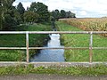
Saalsdorf is located in the far east of Lower Saxony, only about one kilometer from the state border to Saxony-Anhalt . The Aller flows east of Saalsdorf . The landscape around Saalsdorf is counted as part of the Helmstedter Holzland . In the east and south of the village hall, the extended conservation area Harbke-Allertal . Country roads lead to Mackendorf in the west, to Altena and Lockstedt in the north , and to Seggerde and Döhren in the south . The road to Weferlingen , today the closest shopping area for Saalsdorf, is closed to general vehicle traffic. The Braunschweiger Verkehrs-GmbH bus routes run from Saalsdorf to Helmstedt and Wolfsburg .
history
Saalsdorf was first mentioned in a document as Selestorp in 1179 . In earlier times Saalsdorf belonged to the Diocese of Halberstadt . The present church was built in the 18th century. The aristocratic court for Saalsdorf was Altena, it was abolished in the French period . From 1807 to 1813 Saalsdorf belonged to the canton of Weferlingen in the Helmstedt district , in the Oker department of the Kingdom of Westphalia . In 1871, the oak that is still standing today was planted on the village square. In 1908 the first sports club in Saalsdorf, the gymnastics club Brunonia , was founded in the Fricke restaurant . First of all, gymnastics took place in the restaurant hall.
From 1945 on, Saalsdorf was on the inner-German border , so that the place was cut off from the previous power supply provided by Landelektronik GmbH Halle (Saale) . Therefore, a new power line was laid, which led from Mackendorf via Saalsdorf to Altena and was fed by Landelektronik GmbH Fallersleben . In 1949 a public library was founded in Saalsdorf. As a result of the flight and expulsion of Germans from Central and Eastern Europe from 1945–1950 , the population of Saalsdorf increased from 363 (1939) to 644 (1950), of which 226 were displaced in 1950 . In the decades that followed, the number of inhabitants decreased again due to the remote location of Saalsdorf on the GDR border and the low number of jobs. Nevertheless, smaller new building areas emerged, and a second grocery store was built on the outskirts of Mackendorf.
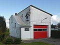
In 1967 a threshing machine shed was converted into today's fire station. Saalsdorf has belonged to the municipality of Bahrdorf since July 1, 1972. In 1973 Saalsdorf was the last place in the Helmstedt district to be connected to the central water supply.
On February 11, 1990, the border to Lockstedt was opened in the course of the fall of the Berlin Wall .
Residents
| year | 1821 | 1849 | 1871 | 1905 | 1925 | 1939 | 1950 | 1956 |
|---|---|---|---|---|---|---|---|---|
| Residents | 393 | 388 | 422 | 360 | 417 | 363 | 644 | 477 |
Infrastructure
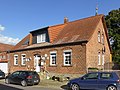
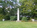
In Saalsdorf there is a village community center, a fire station , a playground, sports facilities and a sports center, a shooting range with a shooting range and a cemetery with a chapel and the war memorial commemorating the Saalsdorf victims of the two world wars. As a reminder of the nearby inner German border, there is a GDR border column on the village square today . Retail shops for daily needs are no longer available in Saalsdorf today.
The school, the post office ("Saalsdorf", later "Bahrdorf 2"), the branch of Volksbank eG Velpke , the bakery (Lockstedter Straße 4), the two grocery stores (Am Dorfplatz and Bergstraße 1) and the two restaurants Zur Linde (Fricke , Width 1) and Schwandt (Weferlinger Straße 10) are closed.
The only church in Saalsdorf, the Evangelical-Lutheran Johannes-Baptista-Kirche named after Johannes the Baptist , belongs to the Provostei Vorsfelde of the Evangelical-Lutheran regional church in Braunschweig . The weather vane on the top of the church tower shows the letters Alpha and Omega (Α and Ω), the first and the last letter of the classical Greek alphabet. They are a symbol for the beginning and the end, thus for the comprehensive, for God . The coat of arms above the entrance portal of the church shows, framed by two lions , three round mirrors from the coat of arms of the Von Spiegel family . The inscription below has been pointing to Ernst Ludwig Spiegel , Freyherr zu Dilhenberg, Dom Dechand zu Halberstadt since 1780 . The pastor responsible for the Saalsdorf Church has her seat in Bahrdorf today. Catholics in Saalsdorf belong to the parish of St. Michael in Vorsfelde with the nearby branch church Immaculate Conception of Mary in Velpke . The churches of St. Josef and St. Theresa of the Child Jesus in Weferlingen and St. Norbert in Grasleben are even closer to Saalsdorf, but their catchment area does not include Saalsdorf.
On the Aller, which has an average gradient of 1.75 meters, the Lüthe watermill was operated until at least the 1950s . It is a grinding mill with a turbine, for which an electric motor was also provided.
Existing clubs in Saalsdorf are the Schützenverein Saaldorf 1880 eV, the sports club SV Saalsdorf eV, which dates back to 1908 , the volunteer fire brigade founded in 1936 and the Carnival Association .
photos
All

church
Former school

Village idyll
Fire station
War memorial
graveyard


literature
- Heinz Pohlendt: The district of Helmstedt. Bremen-Horn 1957.
Web links
Individual evidence
- ↑ http://www.velpke.de/verzeichnis/objekt.php?mandat=135680
- ^ History 1970 to 1979 on the website of the district of Helmstedt , accessed on February 25, 2018
- ↑ https://sv-saalsdorf.de.tl/Startseite.htm
- ↑ Saalsdorf local fire brigade in the Helmstedt Wiki
Bahrdorf (core town with Blanken ) | Mackendorf | Rickensdorf | Saalsdorf (with Altena )