District of San Jerónimo de Tunán
| District of San Jerónimo de Tunán | |
|---|---|
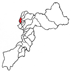
 Location of the district in Huancayo Province |
|
| Basic data | |
| Country | Peru |
| region | Junín |
| province | Huancayo |
| Seat | San Jerónimo de Tunán |
| surface | 21 km² |
| Residents | 12,228 (2017) |
| density | 582 inhabitants per km² |
| founding | October 5, 1854 |
| ISO 3166-2 | PE-JUN |
| politics | |
| Alcalde District | Freddy Pablo Sachahuaman Palacios (2019-2022) |
Coordinates: 11 ° 57 ′ 0 ″ S , 75 ° 16 ′ 59 ″ W.
The district of San Jerónimo de Tunán is located in the Huancayo province of the Junín region in central western Peru . The district was founded on October 5, 1854. It has an area of 21 km². At the 2017 census, there were 12,228 residents in the district. In 1993 the population was 8,268, in 2007 9,658. The district is congruent with the city of the same name San Jerónimo de Tunán . San Jerónimo de Tunán is at an altitude of 3274 m and is located 15 km north-northwest of the provincial and regional capital Huancayo .
Geographical location
The district of San Jerónimo de Tunán is located in the Andean highlands in the northwest of the province of Huancayo. It is located on the left eastern bank of the south-east flowing Río Mantaro south of the city of Concepción .
The district of San Jerónimo de Tunán borders in the southwest with the district Orcotuna , in the northwest with the district Concepción (both of the aforementioned districts are in the province Concepción ), in the north with the district Quichuay , in the northeast with the districts Ingenio and Quilcas and in the southeast the district of San Pedro de Saño .
Individual evidence
- ^ A b Peru: Junín Region - Provinces & Districts . www.citypopulation.de. Retrieved June 13, 2020.