San Luis (Peten)
| San Luis | ||
|---|---|---|
|
Coordinates: 16 ° 12 ′ N , 89 ° 26 ′ W San Luis on the map of Guatemala
|
||
| Basic data | ||
| Country | Guatemala | |
| Department | Peten | |
| City foundation | 1708 | |
| Residents | 44,903 (2002) | |
| - in the metropolitan area | 8,000 | |
| Detailed data | ||
| surface | 2913 km 2 | |
| Population density | 15 people / km 2 | |
| height | 475 m | |
| City structure | 8 districts | |
| Post Code | 17009 | |
| Time zone | UTC −6 | |
| City patron | San Luis IX, Rey de Francia (Festival: August 17th to 25th) | |
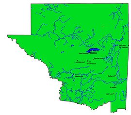
| Peténs map | ||
| The place of San Luis | ||
San Luis is a small town in Guatemala with a population of about 8,000 . San Luis is located in the south-east of the department Peten and is the administrative seat of the municipality of San Luis, which extends over 2,913 km² and has over 50,000 inhabitants.
geography
The place San Luis is located around 35 km west of the border with Belize at an altitude of 475 m. Immediately to the east of the village, the CA 13 road runs past in a north-south direction, which connects Flores , the capital of Pentén, with Izabal in the south and the rest of the country. From San Luis it is 120 km to Flores and around 360 km to Guatemala City .
As with all Municipios Peténs, the main town is located on a major traffic axis, while the administrative area extends far into the back, sparsely populated regions. The municipality of San Luis is located in the western foothills of the Maya Mountains , which reach up to 600 m here. To the south it is largely bounded by the Gracias a Dios and Santa Isabel rivers, and to the west by the Río de la Pasión and one of its tributaries. In general, the climate is tropical and hot.
The neighboring municipalities are Poptún in the north, Dolores in the northwest and Sayaxché in the west. In the south, San Luis borders on the departments of Alta Verapaz and Izabal , and in the east on Belize .
history
The spring-rich area of today's Municipios San Luis was settled by Mopan-Maya long before the Spanish Conquista . In Ixkaj was built around 1700, the present town of San Luis. As early as 1708 he was raised to a municipality, which was confirmed again after Central America's independence in 1832. In the 19th century, only a few hundred people lived in the poorly developed area of San Luis. The construction of the CA 13 trunk road has brought more economic development in recent times, but this was also accompanied by a steady increase in population, the ruthless deforestation of the rainforest , as well as the expansion of secondary routes and the emergence of dead-end villages .
population
In addition to Mopan-Maya and Kekchí , a large part of the local population consists of Ladinos . The municipality consists of the main town San Luis and 127 hamlets.
Economy and Transport
San Luis lives mainly from agriculture, especially from growing corn and beans . The forestry and timber industry is also important . Trade and the service sector play a role on trunk road CA 13. In the far south-east, on the border with Izabal and Belize, at Modesto Méndez (Izabal) a trunk road branches off from CA 13 to the west ( Franja Transversal del Norte ), which after completion of the expansion work via Alta Verapaz and Quiché to Huehuetenango in the north-west Guatemala will lead.
See also
Web links
- Official websites (span.)
- History of San Luis (span.)


