
Quiché department
| El Quiché | |
|---|---|
  |
|
| Data | |
| Capital | Santa Cruz del Quiché |
| population | 1,125,000 (2016) |
| surface | 8,378 km² |
| Population density | 134 people / km² |
| structure | 21st |
| Highest elevation | Cuchumatanes (3,325 m) |
| ISO 3166-2 | GT-QC |
| Website | Inforpressca.com |
 |
|
 |
|
 |
|
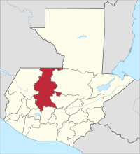
El Quiché is one of 22 departments in Guatemala and is located in the northwest of the country (Region VII) on the border with Mexico . It covers almost 8,400 square kilometers and has about 1,125,000 inhabitants. The capital of the department is Santa Cruz del Quiché .
Quiché borders Mexico to the north, Alta and Baja Verapaz to the east, Chimaltenango and Sololá to the south, Totonicapán and Huehuetenango to the west .
National nature
Quiché is crossed by three mountain ranges in a west-east direction: from the approximately 2500 m high Sierra de Chuacús in the south, the even higher Sierra de los Cuchumatanes in the middle and the much lower Sierra de Chamá in the north. In the far south, in the area of Chichicastenango and Santa Cruz del Quiché, fertile plains at an altitude of about 2,000 m characterize the land, which is traversed by numerous rivers and streams, all of which flow southeast into the Río Motagua , which here at his Upper course is also called Río Grande and forms the border with the Chimaltenango department. Between the Sierra de Chuacús and the Cuchumatanes lies a barren area, furrowed by deep ravines, which is drained by the Río Chixoy (Río Negro) , which also flows eastwards here . After flowing briefly into the neighboring Baja Verapaz and being dammed there, the Chixoy swings in a wide arc through the Cuchumatanes to the north and forms the eastern border of Quiché up to Mexico. The water-rich Cuchumatanes are not (yet) of dense mountain forests covered that extend far to the north and there in the 450 square kilometers of Reserve of the Biosphere VISIS Caba partly under nature were asked. In the far north, beyond the Sierra de Chamá, is the hot and humid tropical rainforest area of the Ixcán, which is only about 100 m above sea level on the border with Mexico . Depending on the altitude, the climate , vegetation and wildlife in the various areas are very different. The entire natural balance is endangered by the sometimes ruthless deforestation of large forest areas for agricultural and forestry purposes. The north is protected from this negative development due to the poor development and general seclusion.
population
The department is named after the Quiché , the largest indigenous people of Guatemala. Due to the often difficult-to-access location of the department, the linguistic diversity and cultural identity among the Mayan descendants has generally been well preserved. In addition to the Spanish colonial language , several Maya languages are spoken in El Quiché : Uspanteco in the municipality of Uspantán, Ixil in Nebaj, Chajul and San Juan Cotzal, Sacapulteco in Sacapulas, Pocomchí in Chicamán, Kekchí in the north and Quiché in the south of the department. The vast majority of the population lives in rural areas, where there is a lack of schools, medical care, electricity and water connections. This explains the high illiteracy, birth, child mortality and poverty rates of Quiché. The approximately 860,000 inhabitants of the department live in a total of 21 municipalities ( large communities or districts ):
As a state administrative district , the department is headed by a governor sent by the central government . The Municipios are independent regional authorities with elected mayors and representatives of the people and are subdivided into Aldeas (rural communities) and Caseríos, Parajes or Fincas ( hamlets and farms ).
Economy and Transport
The most important branch of the Quiché industry is agriculture , which is often subsistence farming . The unfair distribution of land forces many people to work as migrant workers or harvest workers on large fincas or on the Pacific coast, because small plots often cannot ensure the survival of many families. Corn , wheat , beans , various types of fruit and vegetables, tobacco , coffee and sugar cane are grown . The forests also provide precious wood . Cattle breeding is important, especially in the higher elevations, as well as handicrafts (textiles, furniture and other wood products, guitars , jewelry, wicker and leather goods, ceramic products , bricks), trade and, in some cases, tourism.
Due to its location and nature, the department is still inadequately accessible. In the south of the Interamericana at Los Encuentros ( Sololá ) branches off the national road 15 to the north, which leads via Chichicastenango and Santa Cruz del Quiché to Sacapulas at the foot of the Cuchumatanes. It is the most important north-south connection within the department. Beyond the Cuchumatanes, there is no well-developed highway to the north. The winding east-west connection from Huehuetenango via Cunén and Uspantán to Alta Verapaz also runs through Sacapulas . Numerous smaller, often unpaved side roads branch off from these two national roads into the hinterland. The north with its dense, often impenetrable vegetation is still largely undeveloped. In the far north, in the lowlands along the border with Mexico, a new east-west transversal is under construction, the Franja Transversal del Norte , which will probably completely change the economy and infrastructure there. After completion, the effects on nature and wildlife are likely to be similar to those of comparable projects in Petén : the construction of numerous cul- de-sacs in the surrounding area, the uncontrolled increase in settlements and dead-end villages , slash and burn, and the leaching of the soil through unrestrained greed for profit.
The capital Santa Cruz del Quiché has a small airfield for general aviation .
history


The Quiché probably moved from Mexico to the highlands of Guatemala in the 11th century. By subjugating long-established tribes or displacing them to the outskirts, they founded a relatively large empire here, the capital of which K'umarkaaj (called "Utatlán" by the Spaniards) was in the area of today's Quiché department, a few kilometers west of today's capital Santa Cruz del Quiche. The old capital K'umarkaaj was destroyed by the Spaniards and their mercenaries in 1524 after Pedro de Alvarado's troops had defeated a Quiché army under Tecún Umán in an open field battle near Quetzaltenango . Since the Spaniards found no significant mineral or other resources in the impassable area of today's department, they soon neglected it or left it to the monks of the Catholic Church . In Chichicastenango, Dominicans built a church on the remains of the local temple, where in 1702 Father Francisco Ximénez found the Popol Vuh , the holy book of the Council of Quiché. Ximénez, who admired the logic and clarity of the Quiché language , translated the Popol Vuh into Spanish and thus made the masterpiece of Quiché literature and thus its creation story and mythology accessible to posterity.
During the colonial period, Quiché belonged mainly to Totonicapán . The indigenous population lived largely undisturbed in subsistence farming ( Milpa ). Only in the 19th century began the unscrupulous land grabbing of the Ladinos with the plantation economy , which threw the indigenous population into poverty: Since they could not live on their small allotted plots, many people either had to work on site on the large coffee fincas or themselves earn a little extra income as migrant workers on the plantations on the Pacific coast. Precisely because of the unjust distribution of land, the guerrillas found great support in Quiché during the civil war that lasted from 1960 to 1996 . The armed forces of Guatemala were well informed about the real reasons for the war, but defended the claims of the "elites" with relentless harshness. Nowhere else in Guatemala was the civil war as raging as in Quiché, and nowhere else in Quiché was it raging as much as in the Ixil triangle between Nebaj, Chajul and San Juan Cotzal, one of the most scenic areas in Central America. In 2013, the Guatemalan Supreme Court declared that the government's crackdown on the Ixil was genocide . After the war, among other things, the European Union started programs here for moral and material reconstruction. This includes attempts to establish tourism that helps preserve the original way of life of the people. In the past ten years, many refugees have returned from hiding in inaccessible areas and from Mexico to their homeland, where they still live in great poverty.
Attractions
The mass of tourists make a short detour to Chichicastenango on the way to Lake Atitlán or the western highlands to see the hustle and bustle of the local market or to watch the Mayan ceremonies and prayers on the steps of the Santo Tomás Church. Only a few business people profit financially from these short visits, while at the same time the cultural self-image of the local rural population is increasingly losing its basis. Some of the tourists visit K'umarkaaj (Utatlán) near Santa Cruz and several other Mayan ruins that are also open to tourists in the north . The Cuchumatanes and the untouched area north of it are worth seeing, where you can understand the traditional way of life of the Maya descendants particularly well. The road south of the Cuchumatanes from Huehuetenango to Alta Verapaz leads through the towns of Sacapulas, Cunén and Uspatán, which are all suitable as starting points for tours in the Cuchumatanes.
See also
Web links
- Overview of the department (Spanish)
- Even the dead are not safe in Nebaj. (guatemala.de) (PDF; 48 kB)
Individual evidence
Alta Verapaz | Baja Verapaz | Chimaltenango | Chiquimula | El Progreso | Escuintla | Guatemala | Huehuetenango | Izabal | Jalapa | Jutiapa | Petén | Quetzaltenango | Quiché | Retalhuleu | Sacatepéquez | San Marcos | Santa Rosa | Sololá | Suchitepéquez | Totonicapán | Zacapa
Coordinates: 15 ° 30 ′ N , 90 ° 59 ′ W