Sandbach (Stockstadt-Erfelder Altrhein)
|
Sandbach Schwarzbach |
||
|
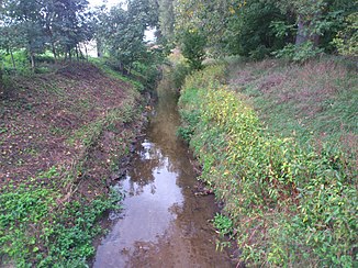
The Sandbach near Pfungstadt |
||
| Data | ||
| Water code | DE : 23964 | |
| location | Hesse | |
| River system | Rhine | |
| Drain over | Stockstadt-Erfelder Altrhein → Rhine → North Sea | |
| Branch | from Modau near Darmstadt-Eberstadt 49 ° 48 ′ 46 ″ N , 8 ° 37 ′ 18 ″ E |
|
| Source height | approx. 105 m above sea level NHN | |
| muzzle | in Riedstadt in the Stockstadt-Erfelder Altrhein ( Rhine ) Coordinates: 49 ° 49 ′ 19 ″ N , 8 ° 28 ′ 39 ″ E 49 ° 49 ′ 19 ″ N , 8 ° 28 ′ 39 ″ E |
|
| Mouth height | approx. 84 m above sea level NHN | |
| Height difference | approx. 21 m | |
| Bottom slope | approx. 1.8 ‰ | |
| length | 11.5 km | |
| Catchment area | 3.4 km² | |
| Drain |
MNQ MQ |
29 l / s 84 l / s |
The Sandbach , also called the Schwarzbach in the lower reaches , is an artificial river in the Hessian Ried . It branches off the Modau near Darmstadt-Eberstadt and flows into the Stockstadt-Erfelder Altrhein in Riedstadt .
geography
course
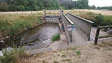
The Sandbach is a flood ditch that is supposed to divert floods from the Modau directly to the Rhine . Between Eberstadt and Pfungstadt there is a controllable weir that can discharge up to 22 m³ / s into the lower lying Sandbach. From there, the Sandbach runs partly in a straight line to the northwest, passing under the federal highway 426 and the federal highway 67 . Between Eschollbrücken and Crumstadt , the Sandbach used to cross the now no longer existing moat. It then flows through an old loop of the former Neckar and takes its only tributary, the Lohrraingraben, from the left. The Sandbach then crosses under the Bundesstraße 44 and the route of the Riedbahn and flows as Schwarzbach near Erfelden into the Old Rhine.
Tributaries
- Lohrraingraben (left)
history
The Sandbach was first mentioned in 1441 in a document from Pfungstadt. This relief channel was dug up to the Rhine in order to divert the Modau floods to the west without having to be discharged into the old Neckar. The Sandbach used to cross the almost silted up meander of what was then the Neckar , which 2000 years ago flowed much further north into the Rhine near Trebur .
After the Neckar changed its course at Ladenburg and flowed directly into the Rhine, the former Neckar course in the Hessian Ried was still preserved. All streams from the Odenwald and the hill country bordering to the north nevertheless flowed into the Altneckar bed. Since it threatened to silt up, the Odenwald waters began to be intercepted in the 16th century and their water continued to be directed north. The ditch was created.
Since then, the Sandbach has crossed the course of the deeper flowing land ditch over a bridge so that the two bodies of water do not touch. After the Odenwald rivers were led directly to the Rhine, the land ditch could be dispensed with in the 1930s and it was filled in.
See also
Web links
Individual evidence
- ↑ Cartographic representation of the Sandbachlauf . TK 1: 25,000 In: Landesgeschichtliches Informationssystem Hessen (LAGIS).
- ↑ Measured via Google Earth
- ↑ Results table of the program of measures for surface waters , website for the implementation of the Water Framework Directive in Hesse ( information )
- ↑ Retention cadastre for the Modau river basin (pdf)
- ↑ Modau area water board (pdf)
- ↑ stadtlandsand.de

