Tambo District (Huaytará)
| Tambo District | |
|---|---|
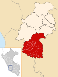
 The Tambo district is located in the central west of the Huaytará province (marked in red) |
|
| Basic data | |
| Country | Peru |
| region | Huancavelica |
| province | Huaytará |
| Seat | Santa Rosa de Tambo |
| surface | 228 km² |
| Residents | 719 (2017) |
| density | 3.2 inhabitants per km² |
| founding | January 12, 1921 |
| ISO 3166-2 | PE-HUV |
| politics | |
| Alcalde District | Hector Leopoldo Bautista Benavides (2019-2022) |
Coordinates: 13 ° 41 ′ S , 75 ° 17 ′ W
The Tambo District is located in the Huaytará Province in the Huancavelica region in south- central Peru . The district was founded on January 12, 1921. It has an area of 228 km². The 2017 census counted 719 inhabitants. In 1993 the population was 1138, in 2007 it was 521. The district administration is located in the 3141 m high village of Santa Rosa de Tambo (or Tambo for short) with 308 inhabitants (as of 2017). Santa Rosa de Tambo is located 12 km southeast of the provincial capital Huaytará .
Geographical location
The Tambo district is located in the Peruvian Western Cordillera in the central west of the Huaytará province. The upper reaches of the Río Tambo, the right source of the Río Ica , crosses the district in a south-westerly direction.
The Tambo district borders on the Ayaví district in the west, the Huaytará and San Antonio de Cusicancha districts in the northwest, the Pilpichaca district in the north and the Santo Domingo de Capillas district in the southeast .
Web links
- Peru: Huancavelica region (provinces and districts) at www.citypopulation.de
- INEI Perú