Santo Domingo de Capillas district
| Santo Domingo de Capillas district | |
|---|---|
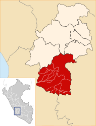
 The Santo Domingo de Capillas district is centrally located in the Huaytará province (marked in red) |
|
| Basic data | |
| Country | Peru |
| region | Huancavelica |
| province | Huaytará |
| Seat | Santo Domingo de Capillas |
| surface | 256 km² |
| Residents | 788 (2017) |
| density | 3.1 inhabitants per km² |
| founding | January 26, 1956 |
| ISO 3166-2 | PE-HUV |
| politics | |
| Alcalde District | Ricardo Jose Vacas Cardenas (2019-2022) |
| Santo Domingo de Capillas | |
Coordinates: 13 ° 44 ′ S , 75 ° 15 ′ W
The Santo Domingo de Capillas district is located in the Huaytará province in the Huancavelica region in south- central Peru . The district was established on January 26, 1956. It has an area of 256 km². The 2017 census counted 788 inhabitants. In 1993 the population was 1165, in 2007 it was 1081. The district administration is located in the 3367 m high village of Santo Domingo de Capillas with 176 inhabitants (as of 2017). Santo Domingo de Capillas is located 19 km southeast of the provincial capital Huaytará .
Geographical location
The district of Santo Domingo de Capillas is located in the Peruvian Western Cordillera, centrally in the province of Huaytará. The longitudinal extent in SW-NE direction is almost 47 km. The Tambo, the right source river of the Río Ica , drains a large part of the district to the southwest. The extreme northeast lies in the catchment area of the Río Olaya, the left headwaters of the Río Ica.
The district of Santo Domingo de Capillas borders in the south with the district San Francisco de Sangayaico , in the northwest and in the north with the districts Ayaví and Tambo , in the northeast with the district Pilpichaca and in the southeast with the district Santiago de Chocorvos .
Localities
In addition to the main town, the district has the following larger towns:
- Taquiza
- Vista Alegre
Web links
- Peru: Huancavelica region (provinces and districts) at www.citypopulation.de
- INEI Perú
