Oh (blue)
| Oh | ||
|
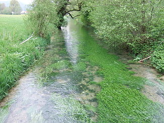
The Ach just below its source |
||
| Data | ||
| Water code | DE : 11522 | |
| location |
Baden-Württemberg
|
|
| River system | Danube | |
| Drain over | Blue → Danube → Black Sea | |
| source | Axis origin for Schelblades 48 ° 22 ′ 37 ″ N , 9 ° 43 ′ 1 ″ E |
|
| Source height | 535 m above sea level NN | |
| Spring discharge |
MNQ MQ MHQ |
110 l / s 440 l / s 1.2 m³ / s |
| muzzle | In Blaubeuren in the blue coordinates: 48 ° 24 ′ 57 ″ N , 9 ° 47 ′ 10 ″ E 48 ° 24 ′ 57 ″ N , 9 ° 47 ′ 10 ″ E |
|
| Mouth height | 515 m above sea level NN | |
| Height difference | 20 m | |
| Bottom slope | 2 ‰ | |
| length | 10.2 km | |
| Left tributaries | Origin | |
|
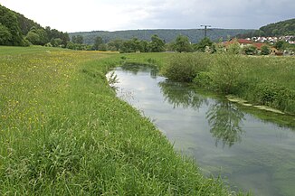
Achtal at Schelklingen |
||
The Ach (also Schelklinger Ach , from Blaubeuren- Weiler also Aach or Schelklinger Aach ) is a 10.2 km long right tributary of the Blau in Baden-Württemberg , Germany .
Ach origin
The Ach rises west of Schelklingen in the Achursprung ( 535 m above sea level ), a karst spring at the Dreikönigsmühle and about 500 m south of the Urspring Monastery . It is a circular, bluish shimmering spring pot, with an average flow of 440 liters per second (min. 110 l / s, max. 1,200 l / s).
course
After only around 100 m of the river, you will find the long and more water-rich Urspring on the left, which rises near the Urspring Monastery . The Ach runs along its entire course in an ancient Danube valley . As far as Schelklingen it then flows in an easterly direction, but then turns to the northeast. Before its confluence, the Ach bei Weiler flows around the Bruckfels near Geißenklösterle and the Weilerhalde in two wide loops, before flowing through Blaubeuren and at 515 m above sea level. NN flows into the still young blue .
On its 10.2 km long path, the Ach falls by 20 m, which corresponds to a mean bed gradient of 2 ‰.
Sights and buildings
The Hohenschelklingen ruins and the St. Afra Chapel with its Gothic fresco cycle are located in Schelklingen . In the Ach Valley is the Hohle Fels , one of the largest cave halls in the Swabian Alb and southern Germany, in which archaeologically important finds were made. On the opposite flank of the valley stands the Sirgenstein , a twenty meter high rock with a Stone Age cave ( Sirgensteinhöhle ), abri and a medieval castle ruin ( Burgrest Sirgenstein ). Further down the valley on main hiking trail 2 of the Swabian Alb Association are the ruins of Günzelburg and other Stone Age caves, the Geißenklösterle and the Brillehöhle . Thus, the Achtal is home to several caves of the world cultural heritage site Caves and Ice Age Art of the Swabian Alb .
In Blaubeuren there is the Blautopf and the neighboring former monastery of Blaubeuren with its monastery church, the Rusenschloss and the hammer mill.
economy

Tourism
The Ach is used by water sports enthusiasts as a delightful canoe . For bird protection reasons, single drivers are not allowed to drive on the Ach between Schelklingen and Blaubeuren every year between March 1st and June 30th, exceptions can be granted by the Ulm Nature Conservation Authority. Organized trips, commercial rentals and events require an official permit all year round.
Importance as a traffic route
The Ach is not navigable. From Schelklingen it is accompanied by the federal road 492 and the Ulm – Sigmaringen railway line .
Web links
Individual evidence
- ↑ Central map server of the LUBW (enter search term)
- ↑ Paddling ( memento of December 24, 2013 in the Internet Archive ) at Naturschutz A – Z , Alb-Donau-Kreis


