Schmachtenberg (Mönchberg)
|
Schmachtenberg
Mönchberg market
Coordinates: 49 ° 47 ′ 2 ″ N , 9 ° 14 ′ 19 ″ E
|
|
|---|---|
| Height : | 258 m above sea level NHN |
| Area : | 3.88 km² |
| Residents : | 405 |
| Population density : | 104 inhabitants / km² |
| Incorporation : | May 1, 1978 |
| Postal code : | 63933 |
| Area code : | 09374 |
|
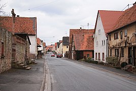
Main street in Schmachtenberg
|
|
Schmachtenberg is a district of Mönchberg in the Miltenberg district in Bavaria .
geography
The parish village Schmachtenberg is located on the district road MIL 2 between Mönchberg and Klingenberg am Main at 258 m above sea level. NHN . To the south of the town lies Röllbach and to the north-west are the villages of Streit and Mechenhard .
The Seltenbach rises to the west of Schmachtenberg , the Röllbach runs in the south and the Langentalgraben and Dreisgraben flow in the north . The district of Schmachtenberg extends into the Hinterer Wald east of Röllfeld . The Franconian Marienweg leads through Schmachtenberg .
history

The village of Schmachtenberg was first mentioned in a document in 1298 and at that time belonged to the Klingenberg taverns . That year it was sold to the Teutonic Order .
In church terms, Schmachtenberg was a branch of the parish of St. Michaelis in Grubingen until the beginning of the 17th century . This period ended when the village of Grubingen went under during the plague . From around 1630 Schmachtenberg belonged to the church of Klingenberg and from 1740 to the parish of Röllbach.
In the 700 years from 1298 there were no other special events that were historically documented. The forest was the main source of income for the community. Until after the Second World War , Schmachtenberg was still completely dominated by agriculture .
On May 1, 1978, the previously independent community was incorporated into Mönchberg. In 1997 Schmachtenberg was enlarged by a new building area. The place has a lively club life and currently has about 400 inhabitants.
church
The magnificent little baroque church by Johann Martin Schmitt from Miltenberg was built from 1759 to 1761 and the choir was added in 1866 . It has a high altar in rococo style and other furnishings to match the style.
Individual evidence
- ↑ Contour lines on the BayernAtlas of the Bavarian State Government ( notes ).
- ↑ Grieben Travel Guide, Volume 137, Spessart, Würzburg and Aschaffenburg, Munich 1972, p. 106
- ^ Franz Schaub, Spessart walks, Süddeutscher Verlag, Munich 1982, ISBN 3-7991-6165-1 , p. 49
- ^ Federal Statistical Office (ed.): Historical municipality directory for the Federal Republic of Germany. Name, border and key number changes in municipalities, counties and administrative districts from May 27, 1970 to December 31, 1982 . W. Kohlhammer GmbH, Stuttgart and Mainz 1983, ISBN 3-17-003263-1 , p. 751 .
Web links
- Schmachtenberg in the local database of the Bayerische Landesbibliothek Online . Bavarian State Library
