
Schober (Salzkammergut Mountains)
| Schober | ||
|---|---|---|
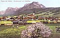
 Schober from the west end of the Fuschlsee towards the east: on the left the main summit, on the right the bald head of the woman's head ; left at the foot of the Wartenfels rock |
||
| height | 1328 m above sea level A. | |
| location | Upper Austria and Salzburg , Austria | |
| Mountains | Salzkammergut mountains | |
| Dominance | 6.5 km → Faistenauer Schafberg | |
| Notch height | 568 m ↓ Einsiedl | |
| Coordinates | 47 ° 48 '46 " N , 13 ° 18' 44" E | |
|
||
| rock | Banked Dachstein limestone , Wetterstein limestone , main dolomite , Ramsaudolomite | |
| Age of the rock | Ladinium - Rhaetium - Lower Carnium | |
| Normal way | from the west over exposed path | |

The Schober is a mountain in the Salzkammergut Mountains in the Salzkammergut , on the border between Upper Austria and Salzburg .
Description and geology
The Schober belongs to the Schafberg group of the Salzkammergut mountains.
With its 1328 m above sea level. A. the Schober is the highest elevation on the edge of the terrain, the logical continuation of which over the Schatzwand ( 1264 m above sea level ) is the imposing Drachenwand ( 1176 m above sea level ) above the Mondsee . She is one of hundreds in the area Salzkammergut-meter-high demolition front of the overthrust ceiling of Dachsteinkalks against the low foothills of the flysch zone ( Kolomansberg ) to Alpine foothills . To the west, the foot of the Drachenwand-Schober-Kante runs into the Thalgauegg corridor between Thalgau and Fuschlsee , which, broken by the Fuschler Ache, ends in the Heuberg near Salzburg. In front of the demolition there is a wooded debris foot with mighty block heaps on the north side .
The south-facing slopes are wooded and fall in the middle against Fuschlsee and Eibenseebach from the Eibensee .
In front of the Schobergipfel to the south, the secondary summit Frauenkopf ( 1304 m above sea level ) rises above Fuschl am See .
Routes, huts
On the summit of the Schober there is an emergency shelter of the PES , the Schoberhütte .
- The normal route runs from the car park ( 924 m above sea level ), past the Wartenfels ruins, through rocky terrain towards the summit. Since the route under the summit leads over step brackets and along a wire rope through exposed terrain, a certain degree of surefootedness and a head for heights is required.
- The second route also starts at the parking lot, but branches off to the right after about 5 minutes. Most of the time, the path runs through light forest, a few meters below the Frauenkopf to the summit. This route is longer, but requires fewer hiking skills and is therefore more suitable for inexperienced people.
Wartenfels
The remains of Wartenfels Castle rise at the western foot of the Schober .
photos
view
- North-west-east elevation
Thalgau , looking south-east: With Schober, Drachenwand and - as a point between the two outstanding - Schafberg (around 1905: in front a set of the Salzkammergut local railway )

View from Schloss Fuschl , in east direction: Schober (left); Middle Höllkar ( 1169 m ) and Ellmaustein ( 1047 m , above Fuschl), in between far the Schafberg, on the right far Dead Mountains over Bad Ischl (view through the Wolfgangsee - Ischler Achen furrow)

View from Schoberstein ( 1037 m , Höllengebirge ), to the west: Drachenwand- Schober-Kante (right);
View over Attersee , Unterach am Attersee , Mondsee , Schafberg (left) with Ackerschneid and Kienbergwand (middle), Hochplett (far right).
View of the summit cross of the Frauenkopf


view
The view from the Schober includes the Fuschlsee with the town of Fuschl , the wide and flat valley of the Fuschler Ache / Griesler Ache from Thalgau to Mondsee , beyond the Westautobahn and the Kolomansberg , the Irrsee and the Mondsee.
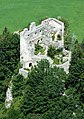
Wartenfels castle ruins, from the west ridge of the Schobers

Location Fuschl and Fuschlsee from the Frauenkopf

