Stadelbach (Würm)
|
Stadelbach Oberlaufname: Seegraben |
||
| Data | ||
| Water code | DE : 2384488 | |
| location |
Neckar basin
|
|
| River system | Rhine | |
| Drain over | Würm → Nagold → Enz → Neckar → Rhine → North Sea | |
| source | of the Seegraben approx. 0.5 km east of the outskirts of Friolzheim on the south side of the A 8 48 ° 50 ′ 6 ″ N , 8 ° 51 ′ 15 ″ E |
|
| Source height | approx. 471 m above sea level NHN | |
| muzzle | to Tiefenbronn- Mühlhausen an der Würm from the right and northeast into the Würm coordinates: 48 ° 48 '20 " N , 8 ° 48' 42" E 48 ° 48 '20 " N , 8 ° 48' 42" E |
|
| Mouth height | approx. 360 m above sea level NHN | |
| Height difference | approx. 111 m | |
| Bottom slope | approx. 21 ‰ | |
| length | 5.4 km | |
| Catchment area | 6.721 km² | |
The Stadelbach is a creek over five kilometers long in the Enzkreis in Baden-Württemberg , which rises as a Seegraben east of Friolzheim and flows into the Würm from the right below the village of Mühlhausen an der Würm von Tiefenbronn .
geography
course
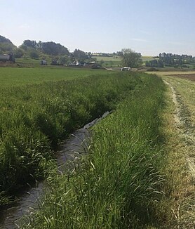
The Stadelbach rises as a ditch on the northwestern slope of the Dünnberg, the northeasternmost branch of the Betzenbuckel in the nature reserve named after it in the Heckengäu . Over a length of approx. 4 kilometers, it flows canalised from there, partly underground, in a trough on the northwest side of the range of hills of the nature reserve, past the Tiefenbronner Seewiesen . There it crosses under the Tiefenbronner Straße (K 4653) and then flows in the same south-westerly direction under the name Stadelbach, until it flows into the Würm from the right just below the Tiefenbronn village of Mühlhausen an der Würm .
Tributaries
From the source to the mouth:
- Brühlgraben (?), From the right to about 433 m above sea level. NHN across from the Friolzheim sewage treatment plant, around 1.0 km. Arises in Friolzheim.
- (Ditch from the direction of the Mühlhof), from the right to about 425 m above sea level. NHN after crossing under the L 1176 Friolzheim – Heimsheim, 0.7 km
- Seegraben (!), From the right to about 415 m above sea level. NHN in the Tiefenbronner Seewiesen, 0.6 km
-
 Passes a pond on the right of the run at about 400 m above sea level. NHN at the entrance to the forest ridge of the lower reaches, over 0.1 ha.
nature
In the middle of the 20th century, the bed of the Seegraben was straightened and partially covered with concrete half-shells, its embankments paved with natural stones. The aim was to make the Seegraben, a third-order body of water, more suitable as a receiving water for draining and relieving the rainwater and mixed water system of Friolzheim. However, this led to the fact that the water, unlike at the time of its freely meandering course before, drained faster and now, especially in late summer, often has a very reduced flow or even falls completely dry.
According to a report from 2014, Friolzheim had problems with flooding due to an insufficiently dimensioned sewer system, which should therefore be upgraded. Since the Seegraben receiving water running along the edge of the village absorbs the water that is then carried away more quickly, this measure would, however, increase the already existing tendency to flood in heavy rain. Therefore, a relief by a retention basin or a widening of the trench cross section of the sea trench was considered.
Protected areas
- Betzenbuckel , nature reserve to the left of the upper course
- Tiefenbronner Seewiesen , nature reserve on both sides of the middle reaches
Individual evidence
LUBW
Official online waterway map with a suitable section and the layers used here: Course and catchment area of the Stadelbach
General introduction without default settings and layers: State Institute for the Environment Baden-Württemberg (LUBW) ( notes )
- ↑ a b Height according to the contour line image on the topographic map background layer .
- ↑ a b c Length according to the waterway network layer ( AWGN ) .
- ↑ Catchment area according to the basic catchment area layer (AWGN) .
- ↑ Lake area after the layer standing waters .
- ↑ Protected areas according to the relevant layer.
Other evidence
- ^ Friedrich Huttenlocher , Hansjörg Dongus : Geographical land survey: The natural spatial units on sheet 170 Stuttgart. Federal Institute for Regional Studies, Bad Godesberg 1949, revised 1967. → Online map (PDF; 4.0 MB)
- ↑ Stuttgarter Zeitung, Stuttgart Germany: Friolzheim: Flood protection demands a lot from the community. Retrieved May 17, 2019 .
literature
- Topographic map 1: 25,000 Baden-Württemberg, as single sheet No. 7118 Pforzheim Süd and No. 7119 Rutesheim
Web links
- Map of the course and catchment area of the Stadelbach on: State Institute for the Environment Baden-Württemberg (LUBW) ( information )
- Measuring table sheets in the Deutsche Fotothek :
- 7118 Wurmberg from 1906
- 7119 Weissach from 1900
